


Yerevan (Erban – Urban)
Er/Ur/Ar – To create – Van/Ban – Home/Nest
-
Er/Ur/Ar – Urartu – Armenia
In Sumerian  (URU) is written before the city name, often in combination with
  (KI) after the city names. Cities are often indicated with their Sumerian names (Akkadian logograms): meaning: Sum. uru `city’, Akk. alu(m) `city’.
 - urununki, Eridu, the city Eridu, home of the water god Ea.

 – uru unug ki, Ur, the city Ur, important port in South Mesopotamia and home of the moon god Sîn.


Urbanization
Urbanization is the increasing number of people that migrate from rural to urban areas. It predominantly results in the physical growth of urban areas, be it horizontal or vertical. The United Nations projected that half of the world’s population would live in urban areas at the end of 2008. By 2050 it is predicted that 64.1% and 85.9% of the developing and developed world respectively will be urbanized.
Urbanization is closely linked to modernization, industrialization, and the sociological process of rationalization. Urbanization can describe a specific condition at a set time, i.e. the proportion of total population or area in cities or towns, or the term can describe the increase of this proportion over time. So the term urbanization can represent the level of urban development relative to overall population, or it can represent the rate at which the urban proportion is increasing.
Urbanization is not merely a modern phenomenon, but a rapid and historic transformation of human social roots on a global scale, whereby predominantly rural culture is being rapidly replaced by predominantly urban culture.
The last major change in settlement patterns was the accumulation of hunter-gatherers into villages many thousand years ago. Village culture is characterized by common bloodlines, intimate relationships, and communal behavior whereas urban culture is characterized by distant bloodlines, unfamiliar relations, and competitive behavior.
From the development of the earliest cities in Mesopotamia and Egypt until the 18th century, an equilibrium existed between the vast majority of the population who engaged in subsistence agriculture in a rural context, and small centres of populations in the towns where economic activity consisted primarily of trade at markets and manufactures on a small scale. Due to the primitive and relatively stagnant state of agriculture throughout this period the ratio of rural to urban population remained at a fixed equilibrium.
With the onset of the agricultural and industrial revolution in the late 18th century this relationship was finally broken and an unprecedented growth in urban population took place over the course of the 19th century, both through continued migration from the countryside and due to the tremendous demographic expansion that occurred at that time. In England, the urban population jumped from 17% in 1801 to 72% in 1891 (for other countries the figure was: 37% in France, 41% in Prussia and 28% in the United States).
As labourers were freed up from working the land due to higher agricultural productivity they converged on the new industrial cities like Manchester and Birmingham which were experiencing a boom in commerce, trade and industry.
Growing trade around the world also allowed cereals to be imported from North America and refrigerated meat from Australasia and South America. Spatially, cities also expanded due to the development of public transport systems, which facilitated commutes of longer distances to the city centre for the working class.
Urbanization rapidly spread across the Western world and, since the 1950s, it has begun to take hold in the developing world as well. At the turn of the 20th century, just 15% of the world population lived in cities. According to the UN the year 2007 witnessed the turning point when more than 50% of the world population was living in cities, for the first time in human history.
This unprecedented movement of people is forecast to continue and intensify in the next few decades, mushrooming cities to sizes incomprehensible only a century ago. Indeed, today, in Asia the urban agglomerations of Dhaka, Karachi, Jakarta, Mumbai, Delhi, Manila, Seoul and Beijing are each already home to over 20 million people, while the Pearl River Delta, Shanghai-Suzhou and Tokyo are forecast to approach or exceed 40 million people each within the coming decade. Outside Asia, Mexico City, Sao Paulo, New York City, Lagos and Cairo are fast approaching being, or are already, home to over 20 million people.
Urartians
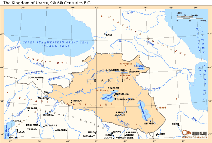
Urartians share mostly of their history together with the Hurrians, excepet that Urartians didn’t take part in the formation of the Hurrian Late Bronze Age kingdom of Mitanni, but continued their existence in states as Nairi (KUR.KUR Na-i-ri, also Na-‘i-ru) and later Urartu (Armenian: Urartu, Assyrian: māt Urarṭu; Babylonian: Urashtu).
The name Urartu (Armenian: Urartu, Assyrian: māt Urarṭu; Babylonian: Urashtu), corresponding to Kingdom of Ararat or Kingdom of Van (Urartian: Biai, Biainili – from which is derived the Armenian toponym “Van”), comes from Assyrian sources.
The Assyrian King Shalmaneser I (1274–1245 BC or 1263–1234 BC) recorded a campaign in which he subdued the entire territory of “Uruatri” in 1274 BC. Uruartri itself was in the region centred around Lake Van in the Armenian Highlands.
The Shalmaneser text uses the name Uratri to refer to a geographical region, not a kingdom. The Assyrian inscriptions mention Uruartri as one of the states of Nairi which he conquered and names eight “lands” contained within Urartu (which at the time of the campaign were still disunited).
Shubria, also known as Subartu, was part of the Urartu confederation. Later, there is reference to a district in the area called Arme or Urme, which some scholars have linked to the name Armenia.
Strictly speaking, Urartu is the Assyrian term for a geographical region, while “kingdom of Urartu” or “Biainili lands” are terms used in modern historiography for the Iron Age state that arose in that region. The kingdom rose to power in the mid-9th century BC, but was conquered by Media in the early 6th century BC.
That a distinction should be made between the geographical and the political entity was already pointed out by König (1955). The landscape corresponds to the mountainous plateau between Asia Minor, Mesopotamia, and the Caucasus mountains, later known as the Armenian Highlands.
According to archaeological data farming on the territory of Urartu began to develop since the Neolithic period, even in the 3rd millennium BC. In Urartian age agriculture was well developed and closely related to the Assyrian on the selection of cultures and ways of processing.
Hurrian & urartian
The Hurro-Urartian language family are an extinct language family of the Ancient Near East, comprising only two known languages: Hurrian and Urartian, both of which were spoken in the triangle made up of the Taurus, Caucasus and Zagros mountains, an area also known as the Armenian highland.
Hurro-Urartian is ergative, agglutinative languages, and is neither related to the Semitic nor to the Indo-European language families. I.M. Diakonoff and S. Starostin see similarities between the Hurro-Urartian languages and the Northeast Caucasian languages, and thus place it in the Alarodian family.
Urartian and Hurrian is closely related. The closeness holds especially true of the so-called Old Hurrian dialect, known above all from Hurro-Hittite bilingual texts, but the two languages must have developed quite independently from approximately 2000 BCE onwards. Although Urartian is not a direct continuation of any of the attested dialects of Hurrian, many of its features are best explained as innovative developments with respect to Hurrian as we know it from the preceding millennium.
Proponents of linguistic macrofamilies have suggested that Hurro-Urartian is part of an “Alarodian” phylum, together with Northeast Caucasian and further as “Macro-Caucasian”, but these theories are without support in mainstream linguistics.
Hurrian is a conventional name for the language of the Hurrians, a people who entered northern Mesopotamia, Syria and the southeastern parts of Anatolia from the Armenian highland around 2300 BC and had mostly vanished by 1000 BC.
Archeologists have discovered the texts of numerous spells, incantations, prophecies and letters at sites including Hattusha, Mari, Tuttul, Babylon, Ugarit and others. The earliest Hurrian text fragments consist of lists of names and places from the end of the third millennium BC. The first full texts date to the reign of king Tish-atal of Urkesh and were found on a stone tablet accompanying the Hurrian foundation pegs known as the “Urkish lions.” At the start of the second milliennium BC.
There have been various Hurrian-speaking states, of which the most prominent one was the kingdom of Mitanni kingdom in northern Mesopotamia (1450–1270 BC), and was likely spoken at least initially in Hurrian settlements in Syria. There was also a Hurrian-Akkadian creole, called Nuzi, spoken in the Mitanni provincial capital of Arrapha.
There was also a strong Hurrian influence on Hittite culture in ancient times, so many Hurrian texts are preserved from Hittite political centres. The Mitanni variety is chiefly known from the so-called “Mitanni letter” from Hurrian Tushratta to pharaoh Amenhotep III surviving in the Amarna archives. The “Old Hurrian” variety is known from some early royal inscriptions and from religious and literary texts, especially from Hittite centres.
The Hurrian of the Mitanni letter differs significantly from that used in the texts at Hattusha and other Hittite centres, as well as from earlier Hurrian texts from various locations. The non-Mitanni letter varieties, while not entirely homogeneous, are commonly subsumed under the designation Old Hurrian.
In the thirteenth century BC, invasions from the west by the Hittites and the south by the Assyrians brought the end of the Mitanni empire, which was divided between the two conquering powers. In the following century, attacks by the Sea Peoples brought a swift end to the last vestiges of the Hurrian language.
It is around this time that other languages, such as the Hittite language and the Ugaritic language also became extinct, in what is known as the Bronze Age collapse. In the texts of these languages, as well as those of Akkadian or Urartian, many Hurrian names and places can be found.
Urartian, Vannic, and (in older literature) Chaldean (Khaldian, or Haldian), is attested from the late 9th century BC to the late 7th century BC as the official written language of the state of Urartu and was probably spoken by the inhabitants of the ancient kingdom of Urartu that was located in the region of Lake Van, with its capital near the site of the modern town of Van, in the Armenian Highland, modern-day Eastern Anatolia region of Turkey.
It was probably spoken by the majority of the population in the mountainous areas around Lake Van and the upper Zab valley. It must have branched off from Hurrian approximately at the beginning of second millennium BC.
It has also been proposed that two little known groups, the Nairi and the Mannae, might have been Urartian speakers, but as little is known about them, it is hard to draw any conclusions about what languages they spoke.
First attested in the 9th century BCE, Urartian ceased to be written after the fall of the Urartian state in 585 BCE, and presumably it became extinct due to the fall of Urartu. It must have been replaced by an early form of Armenian, perhaps during the period of Achaemenid Persian rule, although it is only in the fifth century CE that the first written examples of Armenian appear.
It survives in many inscriptions found in the area of the Urartu kingdom, written in the Assyrian cuneiform script. There have been claims of a separate autochthonous script of “Urartian hieroglyphs” but these remain unsubstantiated. The inscription corpus is too sparse to substantiate the hypothesis. It remains unclear whether the symbols in question form a coherent writing system, or represent just a multiplicity of uncoordinated expressions of proto-writing or ad-hoc drawings.
Urartu
Urartu, corresponding to the biblical Kingdom of Ararat or Kingdom of Van (Urartian: Biai, Biainili) was an Iron Age kingdom centred around Lake Van in the Armenian Highlands.
Strictly speaking, Urartu is the Assyrian term for a geographical region, while “kingdom of Urartu” or “Biainili lands” are terms used in modern historiography for the Proto-Armenian (Hurro-Urartian) speaking Iron Age state that arose in that region.
That a distinction should be made between the geographical and the political entity was already pointed out by König (1955). The landscape corresponds to the mountainous plateau between Asia Minor, Mesopotamia, and the Caucasus mountains, later known as the Armenian Highlands.
The kingdom rose to power in the mid-9th century BC, but was conquered by Media in the early 6th century BC. The heirs of Urartu are the Armenians and their successive kingdoms.
Urartu comprised an area of approximately 200,000 square miles (520,000 km2), extending from the river Kura in the north, to the northern foothills of the Taurus Mountains in the south; and from the Euphrates in the west to the Caspian sea in the east.
At its apogee, Urartu stretched from the borders of northern Mesopotamia to the southern Caucasus, including present-day Armenia and southern Georgia as far as the river Kura.
Archaeological sites within its boundaries include Altintepe, Toprakkale, Patnos and Cavustepe. Urartu fortresses included Erebuni (present day Yerevan city), Van Fortress, Argishtihinili, Anzaf, Cavustepe and Başkale, as well as Teishebaini (Karmir Blur, Red Mound) and others.
Subartu/Hurrians
The land of Subartu (Akkadian Šubartum/Subartum/ina Šú-ba-ri, Assyrian mât Šubarri) or Subar (Sumerian Su-bir4/Subar/Šubur) is mentioned in Bronze Age literature. The name also appears as Subari in the Amarna letters, and, in the form Šbr, in Ugarit, and came to be known as the Hurrians or Subarians and their country was known as Subir, Subartu or Shubar.
Subartu was apparently a polity in Northern Mesopotamia, at the upper Tigris. Most scholars accept Subartu as an early name for Assyria proper on the Tigris, although there are various other theories placing it sometimes a little farther to the east, north or west of there. Its precise location has not been identified.
From the point of view of the Akkadian Empire, Subartu marked the northern geographical horizon, just as Martu, Elam and Sumer marked “west”, “east” and “south”, respectively.
The Sumerian mythological epic Enmerkar and the Lord of Aratta lists the countries where the “languages are confused” as Subartu, Hamazi, Sumer, Uri-ki (Akkad), and the Martu land (the Amorites).
Similarly, the earliest references to the “four quarters” by the kings of Akkad name Subartu as one of these quarters around Akkad, along with Martu, Elam, and Sumer. Subartu in the earliest texts seem to have been farming mountain dwellers, frequently raided for slaves.
Eannatum of Lagash was said to have smitten Subartu or Shubur, and it was listed as a province of the empire of Lugal-Anne-Mundu; in a later era Sargon of Akkad campaigned against Subar, and his grandson Naram-Sin listed Subar along with Armani (Armenians), -which has been identified with Aleppo-, among the lands under his control. Ishbi-Erra of Isin and Hammurabi also claimed victories over Subar. Aratta has been the oldest state in the Armenian Highland, particularly in the Ayrarat district. Atta means father.
A link between Subarians, who from the earliest historical periods are found not only occupying vast mountainous areas north of Babylonia but also living peacefully within Babylonia side by side with Sumerians and Akkadians, in the east and the much younger Hurrians, who appeared relatively late on the Mesopotamian scene and who played an important role in the history of the Near East in the 2nd millennium BC, in the west was established eventually with the aid of personal names — first from Babylonia and subsequently from Nuzi.
Meanwhile, extra-cuneiform connections of the Hurrians proved to include the biblical Horites as well as sundry Egyptian analogues. With this mounting evidence for the expansion of the Hurrians came also recognition of their substantial influence on other cultures — the Hittite, the Assyrian, and the Canaanite — involving such fields as political history, law and society, religion, art, and linguistics.
The “political and geographic unit” which was one thing to the Babylonians and another thing to the Assyrians. In the former instance it lay ” somewhere between the Tigris, the Zagros Mountains, and the Diyala.” At times it might stand for the whole North.
To the Assyrians, on the other hand, Subartu signified regions in the mountains to the east and north of the Tigris, yet it could extend “sometimes far west into the land of the Amorites and far east into the land of the Elamites.” It is recurring references to the “widespread Subarians ” to the west and northwest of Assyria, which is precisely the territory that figures otherwise as good Hurrian stamping ground.
The Aloridian city culture
The Aloridian urban culture was not represented by a large number of cities. Urkesh was the only Aloridian city in the third millennium BC. In the second millennium BC we know a number of Aloridian cities, such as Arrapha, Harran, Kahat, Nuzi, Taidu and Washukanni – the capital of Mitanni.
Although the site of Washukanni, alleged to be at Tell Fakhariya, is not known for certain, no tell (city mound) in the Khabur Valley much exceeds the size of 1 square kilometer (250 acres), and the majority of sites are much smaller.
The Aloridian urban culture appears to have been quite different from the centralized state administrations of Assyria and ancient Egypt. An explanation could be that the feudal organization of the Aloridian kingdoms did not allow large palace or temple estates to develop.
Aloridian settlements are distributed over three modern countries, Iraq, Syria and Turkey. The heart of the Aloridian world is dissected by the modern border between Syria and Turkey. Several sites are situated within the border zone, making access for excavations problematic.
A threat to the ancient sites are the dam many projects in the Euphrates, Tigris and Khabur valleys. Several rescue operations have already been undertaken when the construction of dams put entire river valleys under water.
The tells, or city mounds, often reveal a long occupation beginning in the Neolithic and ending in the Roman period or later. The characteristic Aloridian pottery, the Khabur ware, is helpful in determining the different strata of occupation within the mounds.
The Aloridian settlements are usually identified from the Middle Bronze Age to the end of the Late Bronze Age, with Tell Mozan (Urkesh) being the main exception.
The first major excavations of Aloridian sites in Iraq and Syria began in the 1920s and 1930s. They were led by the American archaeologist Edward Chiera at Yorghan Tepe (Nuzi), and the British archaeologist Max Mallowan at Chagar Bazar and Tell Brak.
Recent excavations and surveys in progress are conducted by American, Belgian, Danish, Dutch, French, German and Italian teams of archaeologists, with international participants, in cooperation with the Syrian Department of Antiquities.
Haplogroup R1b
It has been hypothetised that R1b people (perhaps alongside neighbouring J2 tribes) were the first to domesticate cattle in northern Mesopotamia some 10,500 years ago. R1b tribes descended from mammoth hunters, and when mammoths went extinct, they started hunting other large game such as bisons and aurochs.
With the increase of the human population in the Fertile Crescent from the beginning of the Neolithic (starting 12,000 years ago), selective hunting and culling of herds started replacing indiscriminate killing of wild animals.
The increased involvement of humans in the life of aurochs, wild boars and goats led to their progressive taming. Cattle herders probably maintained a nomadic or semi-nomadic existence, while other people in the Fertile Crescent (presumably represented by haplogroups E1b1b, G and T) settled down to cultivate the land or keep smaller domesticates.
The analysis of bovine DNA has revealed that all the taurine cattle (Bos taurus) alive today descend from a population of only 80 aurochs. The earliest evidence of cattle domestication dates from circa 8,500 BCE in the Pre-Pottery Neolithic cultures in the Taurus Mountains.
The two oldest archaeological sites showing signs of cattle domestication are the villages of Çayönü Tepesi in southeastern Turkey and Dja’de el-Mughara in northern Iraq, two sites only 250 km away from each others. This is presumably the area from which R1b lineages started expanding – or in other words the “original homeland” of R1b.
The early R1b cattle herders would have split in at least three groups. One branch (M335) remained in Anatolia, but judging from its extreme rarity today wasn’t very successful, perhaps due to the heavy competition with other Neolithic populations in Anatolia, or to the scarcity of pastures in this mountainous environment.
A second branch migrated south to the Levant, where it became the V88 branch. Some of them searched for new lands south in Africa, first in Egypt, then colonising most of northern Africa, from the Mediterranean coast to the Sahel. The third branch (P297), crossed the Caucasus into the vast Pontic-Caspian Steppe, which provided ideal grazing grounds for cattle.
They split into two factions: R1b1a1 (M73), which went east along the Caspian Sea to Central Asia, and R1b1a2 (M269), which at first remained in the North Caucasus and the Pontic Steppe between the Dnieper and the Volga.
It is not yet clear whether M73 actually migrated across the Caucasus and reached Central Asia via Kazakhstan, or if it went south through Iran and Turkmenistan. In the latter case, M73 might not be an Indo-European branch of R1b, just like V88 and M335.
R1b-M269 (the most common form in Europe) is closely associated with the diffusion of Indo-European languages, as attested by its presence in all regions of the world where Indo-European languages were spoken in ancient times, from the Atlantic coast of Europe to the Indian subcontinent, which comprised almost all Europe (except Finland, Sardinia and Bosnia-Herzegovina), Anatolia, Armenia, European Russia, southern Siberia, many pockets around Central Asia (notably in Xinjiang, Turkmenistan, Tajikistan and Afghanistan), without forgetting Iran, Pakistan, northern India and Nepal. The history of R1b and R1a are intricately connected to each others.
Haplogroup J2
Haplogroup J2 is thought to have appeared somewhere in the Middle East towards the end of the last glaciation, between 15,000 and 22,000 years ago. Its present geographic distribution argues in favour of a Neolithic expansion from the Fertile Crescent.
This expansion probably correlated with the diffusion of domesticated of cattle and goats (starting c. 8000-9000 BCE) from the Zagros Mountains and northern Mesopotamia, rather than with the development of cereal agriculture in the Levant (which appears to be linked rather to haplogroups G2 and E1b1b).
A second expansion of J2 could have occured with the advent of metallurgy, notably copper working (from the Lower Danube valley, central Anatolia and northern Mesopotamia), and the rise of some of the oldest civilisations.
The world’s highest frequency of J2 is found among the Ingush (88% of the male lineages) and Chechen (56%) people in the Northeast Caucasus. Both belong to the Nakh ethnic group, who have inhabited that territory since at least 3000 BCE. Their language is distantly related to Dagestanian languages, but not to any other linguistic group.
However, Dagestani peoples (Dargins, Lezgins, Avars) belong predominantly to haplogroup J1 (84% among the Dargins) and almost completely lack J2 lineages.
Other high incidence of haplogroup J2 are found in many other Caucasian populations, including the Azeri (30%), the Georgians (27%), the Kumyks (25%), and the Armenians (22%).
Nevertheless, it is very unlikely that haplogroups J2 originated in the Caucasus because of the low genetic diversity in the region. Most Caucasian people belong to the same J2a4b (M67) subclade. The high local frequencies observed would rather be the result of founder effects, for instance the proliferation of chieftains and kings’s lineages through a long tradition of polygamy, a practice that the Russians have tried to suppress since their conquest of the Caucasus in the 19th century.
Outside the Caucasus, the highest frequencies of J2 are observed in Cyprus (37%), Crete (34%), northern Iraq (28%), Lebanon (26%), Turkey (24%, with peaks of 30% in the Marmara region and in central Anatolia), Greece (23%), Central Italy (23%), Sicily (23%), South Italy (21.5%), and Albania (19.5%), as well as among Jewish people (19 to 25%).
One fourth of the Vlach people (isolated communities of Romance language speakers in the Balkans) belong to J2, considerably more than the average of Macedonia and northern Greece where they live. This, combined to the fact that they speak a language descended from Latin, suggests that they could have a greater part of Roman (or at least Italian) ancestry than other ethnic groups in the Balkans.
Notwithstanding its strong presence in West Asia today, haplogroup J2 does not seem to have been one of the principal lineages associated with the rise and diffusion of cereal farming from the Fertile Crescent and Anatolia to Europe.
The region of origin of J2 is still unclear at present. It is likely that J2 men had settled over most of Anatolia, the South Caucasus and Iran by the end of the Last Glaciation 12,000 years ago.
It is possible that J2 hunter-gatherers then goat/sheep herders also lived in the Fertile Crescent during the Neolithic period, although the development of early cereal agriculture is thought to have been conducted by men belonging primarily to haplogroups E1b1b and G2a.
The first expansion of J2 into Europe probably happened during the Late Glacial and immediate postglacial periods (c. 16 to 10 kya), when Anatolian hunter-gatherers moved into the Balkans. This migration would have included J2b and E-V13 male lineages and assorted J and T maternal lineages (presumably J1c, J2a1, T1a1, T2a1b, T2b, T2e and T2f1).
This population would have occupied the modern regions of western Turkey, Greece, Macedonia, Albania, Serbia and Bulgaria. When farmers and herders expanded from the Fertile Crescent during the Early Neolithic, they would have blended with one another before expanding towards Central Europe and Italy.
J2b seems to have split in two subclades soon after leaving Anatolia, with J2b1 being found mostly in western Anatolia and Greece, while J2b2 expanded from the Balkans to most of Europe, to Central Asia, India and back to the Middle East.
It is very likely that J2a, J1 and G2a were the three dominant male lineages the Early Bronze Age Kura-Araxes culture, which expanded from the South Caucasus to eastern Anatolia, northern Mesopotamia and the western Iran. From then on, J2 men would have definitely have represented a sizeable portion of the population of Bronze and Iron Age civilizations such as the Hurrians, the Assyrians or the Hittites.
Quite a few ancient Mediterranean and Middle Eastern civilisations flourished in territories where J2 lineages were preponderant. This is the case of the Hattians, the Hurrians, the Etruscans, the Minoans, the Greeks, the Phoenicians (and their Carthaginian offshoot), the Israelites, and to a lower extent also the Romans, the Assyrians and the Persians. All the great seafaring civilisations from the middle Bronze Age to the Iron Age were dominated by J2 men.
There is a distinct association of ancient J2 civilisations with bull worship. The oldest evidence of a cult of the bull can be traced back to Neolithic central Anatolia, notably at the sites of Çatal Höyük and Alaca Höyük. Bull depictions are omnipresent in Minoan frescos and ceramics in Crete.
Bull-masked terracotta figurines and bull-horned stone altars have been found in Cyprus (dating back as far as the Neolithic, the first presumed expansion of J2 from West Asia). The Hattians, Sumerians, Babylonians, Canaaites, and Carthaginians all had bull deities (in contrast with Indo-European or East Asian religions).
The sacred bull of Hinduism, Nandi, present in all temples dedicated to Shiva or Parvati, does not have an Indo-European origin, but can be traced back to Indus Valley civilisation.
Minoan Crete, Hittite Anatolia, the Levant, Bactria and the Indus Valley also shared a tradition of bull leaping, the ritual of dodging the charge of a bull. It survives today in the traditional bullfighting of Andalusia in Spain and Provence in France, two regions with a high percentage of J2 lineages.
Haplogroup J1
Since the discovery of haplogroup J it has generally been recognized that it shows signs of having originated in or near West Asia. The frequency and diversity of both its major branches, J1 and J2, in that region makes them candidates as genetic markers of the spread of farming technology during the Neolithic, which is proposed to have had a major impact upon human populations.
J1 has several recognized subclades, some of which were recognized before J1 itself was recognized, for example J-M62 Y Chromosome Consortium “YCC” 2002. With one notable exception, J-P58, most of these are not common. Because of the dominance of J-P58 in J1 populations in many areas, discussion of J1’s origins requires a discussion of J-P58 at the same time.
The P58 marker which defines subgroup J-P58 is very prevalent in many areas where J1 is common, especially in parts of North Africa and throughout the Arabian Peninsula. It also makes up approximately 70% of the J1 among the Amhara of Ethiopia. Notably, it is not common among the J1 populations in the Caucasus.
Chiaroni 2009 proposed that J-P58 (that they refer to as J1e) might have first dispersed during the Pre-Pottery Neolithic B period, “from a geographical zone, including northeast Syria, northern Iraq and eastern Turkey toward Mediterranean Anatolia, Ismaili from southern Syria, Jordan, Palestine and northern Egypt.”
They further propose that the Zarzian material culture may be ancestrals. They also propose that this movement of people may also be linked to the dispersal of Semitic languages by hunter-herders, who moved into arid areas during periods known to have had low rainfall.
Thus, while other haplogroups including J2 moved out of the area with agriculturalists, which followed the rainfall, populations carrying J1 remained with their flocks.
According to this scenario, after the initial neolithic expansion involving Semitic languages, which possibly reached as far as Yemen, a more recent dispersal occurred during the Chalcolithic or Early Bronze Age (approximately 3000–5000 BCE), and this involved the branch of Semitic which leads to the Arabic language.
The authors propose that this involved a spread of some J-P58 from the direction of Syria towards Arab populations of the Arabian Peninsula and Negev.
Hanbi
In Sumerian and Akkadian mythology Hanbi or Hanpa (more commonly known in western text) was the father of Enki, Pazuzu, the king of the demons of the wind, the bearer of storms and drought, and Humbaba, also Humbaba the Terrible, a monstrous giant of immemorial age raised by Utu, the Sun.
Although Pazuzu is, himself, an evil spirit, he drives away other evil spirits, therefore protecting humans against plagues and misfortunes. Humbaba was the guardian of the Cedar Forest, where the gods lived, by the will of the god Enlil.
Enki (Eridu)
Enki (Sumerian: EN.KI(G)) is a god in Sumerian mythology, later known as Ea in Akkadian and Babylonian mythology. He was originally patron god of the city of Eridu, but later the influence of his cult spread throughout Mesopotamia and to the Canaanites, Hittites and Hurrians.
Enki was the deity of crafts (gašam); mischief; water, seawater, lakewater (a, aba, ab), intelligence (gestú, literally “ear”) and creation (Nudimmud: nu, likeness, dim mud, make beer).
Considered the master shaper of the world, god of wisdom and of all magic, Enki was characterized as the lord of the Abzu (Apsu in Akkadian), the freshwater sea or groundwater located within the earth.
Enki was the keeper of the divine powers called Me, the gifts of civilization. His image is a double-helix snake, or the Caduceus, sometimes confused with the Rod of Asclepius used to symbolize medicine. His symbols included a goat and a fish, which later combined into a single beast, the goat Capricorn, recognised as the Zodiacal constellation Capricornus. He is often shown with the horned crown of divinity dressed in the skin of a carp.
Beginning around the second millennium BCE, he was sometimes referred to in writing by the numeric ideogram for “40,” occasionally referred to as his “sacred number.”
The exact meaning of his name is uncertain: the common translation is “Lord of the Earth”: the Sumerian en is translated as a title equivalent to “lord”; it was originally a title given to the High Priest; ki means “earth”; but there are theories that ki in this name has another origin, possibly kig of unknown meaning, or kur meaning “mound”.
Early royal inscriptions from the third millennium BCE mention “the reeds of Enki”. Reeds were an important local building material, used for baskets and containers, and collected outside the city walls, where the dead or sick were often carried. This links Enki to the Kur or underworld of Sumerian mythology.
The main temple to Enki is in Sumerian called E-abzu (E-A), meaning “abzu temple” (also E-en-gur-a, meaning “house of the subterranean waters”), a ziggurat temple surrounded by Euphratean marshlands near the ancient Persian Gulf coastline at Eridu, and it has been suggested that this was originally the name for the shrine to the god at Eridu.
Enkidu
Enkidu (EN.KI.DU3 “Enki’s creation”), earlier transliterated as Enkimdu, Eabani or Enkita, is a central figure in the Ancient Mesopotamian Epic of Gilgamesh. In the story the gods created a man (1/3 man and 2/3 animal) and named him Enkidu, who was created by the gods as the rival to the mighty Gilgamesh. He was formed from clay and saliva by the goddess Aruru, the goddess of creation, to rid Gilgamesh of his arrogance.
God made Adam from clay from the soil too. Both were made to do the will of the god(s), nothing more. They were both made from the same material, in the same way, for the same basic purpose. The difference is that Adam was made by a god, while Enkidu was made by a goddess. So, in the 1500 years separating these two books, women went from being respected while working as prostitutes in the temple to being the first sinner.
Enkidu had beauty and strength only matched by the king, Gilgamesh. He is a wild man, raised by animals and ignorant of human society. Gilgamesh sends out a Temple Prostitute to seduce him, Shamhat, who plays the integral role of taming the wild man Enkidu, because if she had sex with him, the other animals wouldn’t accept him, and he could be civilized.
The goddess who made Enkidu decides that the best way to make Gilgamesh follow their will is to create an equal and teach him humility. But, when the Jews create their God, his solution to the problem of humanity sinning is to “banish him from the Garden of Eden” and “he placed on the east side of the Garden of Eden cherubim and a flaming sword flashing back and forth to guard the way to the tree of life”.
Gilgamesh sleeps with every virgin before her husband can, and they make an equal man to teach him. Adam and Eve eat one apple and they get kicked out and God puts a guy with a freaking flaming sword there to keep them out.
In Genesis a man (Adam) is alone in a natural setting (the garden of Eden) until a woman (Eve) comes to him and does something (eats the forbidden apple) and gets them expelled. The similarities and differences in the stories show similarities and differences in beliefs over time.
She uses her attractiveness to tempt Enkidu from the wild, and his ‘wildness’, civilizing him through continued sexual intercourse. Unfortunately for Enkidu, after he enjoys Shamhat for “six days and seven nights”, his former companions, the wild animals, turn away from him in fright, at the watering hole where they congregated.
According to Adam and Eve, the first two people NEVER had sex while they were perfect. They didn’t have any kids while in the garden. It was only after they discovered sin that they discovered sex. Sex is considered evil in the bible.
The Sumerians were amazed at the power of sex to make another human. Sex was such an incredible thing to them that they even had prostitutes working in the temple to share its wonders with other people. In the story of Gilgamesh, Shamhat, the temple prostitute, is considered trustworthy enough to be entrusted with the task of teaching Enkidu how to be a civilized human.
Shamhat persuades him to follow her and join the civilized world in the city of Uruk, where Gilgamesh is king, rejecting his former life in the wild with the wild animals of the hills. Henceforth, Gilgamesh and Enkidu become the best of friends and undergo many adventures.
Enkidu embodies the wild or natural world, and though equal to Gilgamesh in strength and bearing, acts in some ways as an antithesis to the cultured, urban-bred warrior-king.
Enkidu then becomes the king’s constant companion and deeply beloved friend, accompanying him on adventures until he is stricken ill. The deep, tragic loss of Enkidu profoundly inspires in Gilgamesh a quest to escape death by obtaining godly immortality.
Ninti
Ninti, the title of Ninhursag, also means “the mother of all living”, and was a title given to the later Hurrian goddess Kheba, later known as Cybele. This is also the title given in the Bible to Eve, the Hebrew and Aramaic Ḥawwah (חוה), who was made from the rib of Adam, in a strange reflection of the Sumerian myth, in which Adam — not Enki — walks in the Garden of Paradise.
In the later Babylonian epic Enûma Eliš, Abzu, the “begetter of the gods”, is inert and sleepy but finds his peace disturbed by the younger gods, so sets out to destroy them. His grandson Enki, chosen to represent the younger gods, puts a spell on Abzu “casting him into a deep sleep”, thereby confining him deep underground.
Enki subsequently sets up his home “in the depths of the Abzu.” Enki thus takes on all of the functions of the Abzu, including his fertilising powers as lord of the waters and lord of semen.
In another even older tradition, Nammu, the goddess of the primeval creative matter and the mother-goddess portrayed as having “given birth to the great gods,” was the mother of Enki, and as the watery creative force, was said to preexist Ea-Enki.
Benito states “With Enki it is an interesting change of gender symbolism, the fertilising agent is also water, Sumerian “a” or “Ab” which also means “semen”. In one evocative passage in a Sumerian hymn, Enki stands at the empty riverbeds and fills them with his ‘water’”. This may be a reference to Enki’s hieros gamos or sacred marriage with Ki/Ninhursag (the Earth).
Continuation
In 1964, a team of Italian archaeologists under the direction of Paolo Matthiae of the University of Rome La Sapienza performed a series of excavations of material from the third-millennium BCE city of Ebla. Much of the written material found in these digs was later translated by Giovanni Pettinato.
Among other conclusions, he found a tendency among the inhabitants of Ebla to replace the name of El, king of the gods of the Canaanite pantheon (found in names such as Mikael), with Ia.
Jean Bottero (1952) and others suggested that Ia in this case is a West Semitic (Canaanite) way of saying Ea, Enki’s Akkadian name, associating the Canaanite theonym Yahu, and ultimately Hebrew YHWH.
This hypothesis is dismissed by some scholars as erroneous, based on a mistaken cuneiform reading, but academic debate continues. Ia has also been compared by William Hallo with the Ugaritic Yamm (sea), (also called Judge Nahar, or Judge River) whose earlier name in at least one ancient source was Yaw, or Ya’a.
Isimud
Enki was accompanied by an attendant Isimud (also Isinu; Usmû; Usumu (Akkadian), a minor god, the messenger of the god Enki in Sumerian mythology. He is readily identifiable by the fact that he possesses two faces looking in opposite directions.
In ancient Roman religion and myth, Janus is the god of beginnings and transitions, and thereby of gates, doors, doorways, passages and endings. He is usually depicted as having two faces, since he looks to the future and to the past. The Romans named the month of January (Ianuarius) in his honor.
Mercury
The planet Mercury, associated with Babylonian Nabu (the son of Marduk) was in Sumerian times, identified with Enki. Mercury is the ruling planet of Gemini and Virgo and is exalted in the latter; it is the only planet with rulership and exaltation both in the same sign (Virgo).
Hermes is an Olympian god in Greek religion and mythology, son of Zeus and the Pleiad Maia. He is second youngest of the Olympian gods. He is a god of transitions and boundaries.
Hermes is quick and cunning, and moved freely between the worlds of the mortal and divine, as emissary and messenger of the gods, intercessor between mortals and the divine, and conductor of souls into the afterlife. He is protector and patron of travelers, herdsmen, thieves, orators and wit, literature and poets, athletics and sports, invention and trade.
In some myths he is a trickster, and outwits other gods for his own satisfaction or the sake of humankind. His attributes and symbols include the herma, the rooster and the tortoise, purse or pouch, winged sandals, winged cap, and his main symbol is the herald’s staff, the Greek kerykeion or Latin caduceus which consisted of two snakes wrapped around a winged staff.
“Hermes” may be related to Greek ἑρμηνεύς hermeneus (“interpreter”), reflecting Hermes’s function as divine messenger. The word “hermeneutics”, the study and theory of interpretation, is derived from hermeneus.
In the Roman adaptation of the Greek pantheon Hermes is identified with the Roman god Mercury, who, though inherited from the Etruscans, developed many similar characteristics, such as being the patron of commerce.
In Roman mythology, Mercury is the messenger of the gods, noted for his speed and swiftness. Echoing this, the scorching, airless world Mercury circles the Sun on the fastest orbit of any planet.
Mercury takes only 88 days to orbit the Sun, spending about 7.33 days in each sign of the zodiac. Mercury is so close to the Sun that only a brief period exists after the Sun has set where it can be seen with the naked eye, before following the Sun beyond the horizon.
Astrologically, Mercury represents the principles of communication, mentality, thinking patterns, rationality and reasoning and adaptability and variability. Mercury governs schooling and education, the immediate environment of neighbors, siblings and cousins, transport over short distances, messages and forms of communication such as post, email and telephone, newspapers, journalism and writing, information gathering skills and physical dexterity. The 1st-century poet Manilius described Mercury as an inconstant, vivacious and curious planet.
In medicine, Mercury is associated with the nervous system, the brain, the respiratory system, the thyroid and the sense organs. It is traditionally held to be essentially cold and dry, according to its placement in the zodiac and in any aspects to other planets. It is linked to the animal spirits.
Today, Mercury is regarded as the ruler of the third and sixth houses; traditionally, it had the joy in the first house. Mercury is the messenger of the gods in mythology. It is the planet of day-to-day expression and relationships. Mercury’s action is to take things apart and put them back together again. It is an opportunistic planet, decidedly unemotional and curious.
Mercury rules over Wednesday. In Romance languages, the word for Wednesday is often similar to Mercury (miercuri in Romanian, mercredi in French, miercoles in Spanish and mercoledì in Italian). Dante Alighieri associated Mercury with the liberal art of dialectic.
In Indian astrology, Mercury is called Budha, a word related to Buddhi (“intelligence”) and represents communication. In Chinese astrology, Mercury represents Water, the fourth element, therefore symbolizing communication, intelligence and elegance.
The Chinese linkage of Mercury with Water is alien to Western astrology, but this combination shares the water themes, much of what is coined “mercurial” in Western thought, such as intellect, reason and communication.
Capricorn
Capricorn, called by the Nakh peoples as Roofing Towers (Chechen: Neģara Bjovnaš), is the tenth astrological sign in the zodiac, originating from the constellation of Capricornus. It spans the 270–300th degree of the zodiac, corresponding to celestial longitude. In astrology, Capricorn is considered an earth sign, introvert sign, and one of the four cardinal signs.
Under the tropical zodiac, the sun transits this area from December 22 to January 19 each year, and under the sidereal zodiac, the sun currently transits the constellation of Capricorn from approximately January 15 to February 14.
Capricorn-Sagittarius cusps (those born from December 21 to December 28) are considered to be slightly different from the typical Capricorn, being more outgoing, jovial and less ambitious and money orientated than the Capricorn who is not born on a cusp.
Despite its faintness, Capricornus has one of the oldest mythological associations, having been consistently represented as a hybrid of a goat and a fish since the Middle Bronze Age.
The Encyclopedia Britannica states that the figure of Capricorn derives from the half-goat, half-fish representation of the Sumerian god Enki (Sumerian: EN.KI(G)), later known as Ea in Akkadian and Babylonian mythology.
First attested in depictions on a cylinder-seal from around the 21st century BC, it was explicitly recorded in the Babylonian star catalogues as MULSUḪUR.MAŠ “The Goat-Fish” before 1000 BC. The constellation was a symbol of the god Ea and in the Early Bronze Age marked the winter solstice.
Due to the precession of the equinoxes the December solstice no longer takes place while the sun is in the constellation Capricornus, as it did until 130 BCE, but the astrological sign called Capricorn begins with the solstice. The solstice now takes place when the Sun is in Sagittarius.
The sun’s most southerly position, which is attained at the northern hemisphere’s winter solstice, is now called the Tropic of Capricorn, a term which also applies to the line on the Earth at which the sun is directly overhead at noon on that solstice. The Sun is now in Capricorn from late January through mid-February.
The goat’s broken horn was transformed into the cornucopia or horn of plenty. Capricornus is also sometimes identified as Pan, the god with a goat’s head, who saved himself from the monster Typhon by giving himself a fish’s tail and diving into a river.
The planet Neptune was discovered in Capricornus by German astronomer Johann Galle, near Deneb Algedi (δ Capricorni) on September 23, 1846, which is appropriate as Capricornus can be seen best from Europe at 4:00am in September.
Amalthea
In Greek mythology, the constellation is sometimes mixed with Amalthea, the goat that suckled the infant Zeus after his mother, Rhea, saved him from being devoured by his father, Cronos.
In Greek mythology, Amalthea or Amaltheia is the most-frequently mentioned foster-mother of Zeus. Her name in Greek (“tender goddess”) is clearly an epithet, signifying the presence of an earlier nurturing goddess, whom the Hellenes, whose myths we know, knew to be located in Crete, where Minoans may have called her a version of “Dikte”.
In the tradition represented by Hesiod’s Theogony, Cronus swallowed all of his children immediately after birth. The mother goddess Rhea, Zeus’ mother, deceived her brother consort Cronus by giving him a stone wrapped to look like a baby instead of Zeus.
Since she instead gave the infant Zeus to Adamanthea to nurse in a cave on a mountain in Crete, it is clear that Adamanthea is a doublet of Amalthea. In many literary references, the Greek tradition relates that in order that Cronus should not hear the wailing of the infant, Amalthea gathered about the cave the Kuretes or the Korybantes to dance, shout, and clash their spears against their shields.
“Amaltheia was placed amongst the stars as the constellation Capra—the group of stars surrounding Capella on the arm (ôlenê) of Auriga the Charioteer.” Capra simply means “she-goat” and the star-name Capella is the “little goat”, but some modern readers confuse her with the male sea-goat of the Zodiac, Capricorn, who bears no relation to Amalthea, no connection in a Greek or Latin literary source nor any ritual or inscription to join the two.
Saturn
In astrology, a planet’s domicile is the zodiac sign over which it has rulership. The planet said to be ruler of Capricorn is Saturn. Saturn is the ruling planet of Capricorn and is exalted in Libra.
Saturn is associated with Saturday, which was named after the deity Saturn. Dante Alighieri associated Saturn with the liberal art of astronomia (astrology and astronomy). Saturn the planet and Saturday are both named after the god.
In Roman mythology, Saturn is the god of agriculture, founder of civilizations and of social order, and conformity. The glyph is most often seen as scythe-like, but it is primarily known as the “crescent below the cross”, whereas Jupiter’s glyph is the “crescent above the cross”. The famous rings of the planet Saturn that enclose and surround it, reflect the idea of human limitations.
Astrologically, Saturn is associated with the principles of limitation, restrictions, boundaries, practicality and reality, crystallizing, and structures. Saturn governs ambition, career, authority and hierarchy, and conforming social structures.
It concerns a person’s sense of duty, discipline and responsibility, and their physical and emotional endurance during hardships. Saturn is also considered to represent the part of a person concerned with long-term planning.
Before the discovery of Uranus, Saturn was regarded as the ruling planet of Aquarius. Many astrologers still use Saturn as the planetary ruler of both Capricorn and Aquarius; in modern astrology it is accordingly the ruler of the tenth and eleventh houses. Traditionally, however, Saturn was associated with the first and eighth houses.
In Indian astrology, Saturn is called Shani or “Sani”, and represents career and longevity. It is also the bringer of bad luck and hardship. In Chinese astrology, Saturn is ruled by the element earth, which is warm, generous, and co-operative.
Pegasus
Pegasus is a constellation in the northern sky, named after the winged horse Pegasus, a winged horse with magical powers, in Greek mythology. It was one of the 48 constellations listed by the 2nd-century astronomer Ptolemy, and remains one of the 88 modern constellations. Twelve star systems have been found to have exoplanets.
With an apparent magnitude varying between 2.37 and 2.45, the brightest star in Pegasus is the orange supergiant Epsilon Pegasi, also known as Enif, which marks the horse’s muzzle.
Alpha (Markab), Beta (Scheat), and Gamma (Algenib), together with Alpha Andromedae (Alpheratz or Sirrah) form the large asterism known as the Square of Pegasus.
Enki was associated with the southern band of constellations called stars of Ea, but also with the constellation AŠ-IKU, the Field (Square of Pegasus). The Babylonian constellation IKU (field) had four stars of which three were later part of the Greek constellation Hippos (Pegasus).
Pegasus, one of the best known creatures in Greek mythology, is a winged divine stallion usually depicted as pure white in color. He was sired by Poseidon, in his role as horse-god, and foaled by the Gorgon Medusa. He was the brother of Chrysaor, born at a single birthing when his mother was decapitated by Perseus.
Greco-Roman poets write about his ascent to heaven after his birth and his obeisance to Zeus, king of the gods, who instructed him to bring lightning and thunder from Olympus.
One myth regarding his powers says that his hooves dug out a spring, Hippocrene, the fountain on Mt. Helicon, which blessed those who drank its water with the ability to write poetry. Pegasus was the one who delivered Medusa’s head to Polydectes, after which he travelled to Mount Olympus in order to be the bearer of thunder and lightning for Zeus.
Eventually, he was captured by the Greek hero Bellerophon, who was asked to kill the Chimera, near the fountain Peirene with the help of Athena and Poseidon. Pegasus allows the hero to ride him to defeat a monster, the Chimera, before realizing many other exploits.
Despite this success, after the death of his children, Bellerophon asked Pegasus to take him to Mount Olympus. Though Pegasus agreed, Bellerophon falls off his back trying to reach Mount Olympus. He plummeted back to Earth after Zeus either threw a thunderbolt at him or made Pegasus buck him off.
From earliest times white horses have been mythologized as possessing exceptional properties, transcending the normal world by having wings (e.g. Pegasus from Greek mythology), or having horns (the unicorn).
As part of its legendary dimension, the white horse in myth may be depicted with seven heads (Uchaishravas) or eight feet (Sleipnir), sometimes in groups or singly. There are also white horses which are divinatory, who prophesy or warn of danger.
Personification of the water, solar myth, or shaman mount, Carl Jung and his followers have seen in Pegasus a profound symbolic esoteric in relation to the spiritual energy that allows access to the realm of the gods on Mount Olympus.
Poseidon/ Neptune
Poseidon is one of the twelve Olympian deities of the pantheon in Greek mythology. His main domain is the ocean, and he is called the “God of the Sea”. Additionally, he is referred to as “Earth-Shaker” due to his role in causing earthquakes, and has been called the “tamer of horses”. He is usually depicted as an older male with curly hair and beard.
There is some reason to believe that Poseidon, like other water gods, was originally conceived under the form of a horse. In Greek art, Poseidon rides a chariot that was pulled by a hippocampus or by horses that could ride on the sea, and sailors sometimes drowned horses as a sacrifice to Poseidon to ensure a safe voyage.
The name of the sea-god Nethuns in Etruscan was adopted in Latin for Neptune (Latin: Neptūnus) in Roman mythology; both were sea gods analogous to Poseidon.
Neptune was the Roman god of freshwater and the sea in Roman religion. He is the counterpart of the Greek god Poseidon. In the Greek-influenced tradition, Neptune was the brother of Jupiter and Pluto, each of them presiding over the realms of Heaven, our earthly world, and the Underworld, respectively. Salacia was his consort.
Depictions of Neptune in Roman mosaics, especially those of North Africa, are influenced by Hellenistic conventions. Neptune was likely associated with fresh water springs before the sea. Like Poseidon, Neptune was worshipped by the Romans also as a god of horses, under the name Neptunus Equester, a patron of horse-racing.
Linear B tablets show that Poseidon was venerated at Pylos and Thebes in pre-Olympian Bronze Age Greece as a chief deity, but he was integrated into the Olympian gods as the brother of Zeus and Hades.
According to some folklore, he was saved by his mother Rhea, who concealed him among a flock of lambs and pretended to have given birth to a colt, which was devoured by Cronos.
There is a Homeric hymn to Poseidon, who was the protector of many Hellenic cities, although he lost the contest for Athens to Athena. According to the references from Plato in his dialogue Timaeus and Critias, the island of Atlantis was the chosen domain of Poseidon.
The earliest attested occurrence of the name, written in Linear B, is Po-se-da-o or Po-se-da-wo-ne, which correspond to Poseidaōn and Poseidawonos in Mycenean Greek; in Homeric Greek it appears as Poseidaōn; in Aeolic as Poteidaōn; and in Doric as Poteidan, Poteidaōn, and Poteidas.
A common epithet of Poseidon is Gaiēochos, “Earth-shaker,” an epithet which is also identified in Linear B tablets. Another attested word, E-ne-si-da-o-ne, recalls his later epithets Ennosidas and Ennosigaios indicating the chthonic nature of Poseidon.
The origins of the name “Poseidon” are unclear. One theory breaks it down into an element meaning “husband” or “lord” (Greek posis), from PIE *pótis) and another element meaning “earth” (da), Doric for (gē), producing something like lord or spouse of Da, i.e. of the earth; this would link him with Demeter, “Earth-mother.” Walter Burkert finds that “the second element da- remains hopelessly ambiguous” and finds a “husband of Earth” reading “quite impossible to prove.”
Another theory interprets the second element as related to the word dâwon, “water”; this would make *Posei-dawōn into the master of waters. There is also the possibility that the word has Pre-Greek origin. Plato in his dialogue Cratylus gives two alternative etymologies: either the sea restrained Poseidon when walking as a “foot-bond”, or he “knew many things”.
If surviving Linear B clay tablets can be trusted, the name po-se-da-wo-ne (“Poseidon”) occurs with greater frequency than does di-u-ja (“Zeus”). A feminine variant, po-se-de-ia, is also found, indicating a lost consort goddess, in effect a precursor of Amphitrite, a sea-goddess and wife of Poseidon. In Roman mythology, the consort of Neptune, a comparatively minor figure, was Salacia, the goddess of saltwater.
In the heavily sea-dependent Mycenaean culture, no connection between Poseidon and the sea has yet surfaced. Homer and Hesiod suggest that Poseidon became lord of the sea following the defeat of his father Kronos, when the world was divided by lot among his three sons; Zeus was given the sky, Hades the underworld, and Poseidon the sea, with the Earth and Mount Olympus belonging to all three.
Given Poseidon’s connection with horses as well as the sea, and the landlocked situation of the likely Indo-European homeland, Nobuo Komita has proposed that Poseidon was originally an aristocratic Indo-European horse-god who was then assimilated to Near Eastern aquatic deities when the basis of the Greek livelihood shifted from the land to the sea, or a god of fresh waters who was assigned a secondary role as god of the sea, where he overwhelmed the original Aegean sea deities such as Proteus and Nereus.
Conversely, Walter Burkert suggests that the Hellene cult worship of Poseidon as a horse god may be connected to the introduction of the horse and war-chariot from Anatolia to Greece around 1600 BC. In any case, the early importance of Poseidon can still be glimpsed in Homer’s Odyssey, where Poseidon rather than Zeus is the major mover of events.
Wanax
Poseidon carries frequently the title wa-na-ka (wanax) in Linear B inscriptions, as king of the underworld, and his title E-ne-si-da-o-ne in Mycenean Knossos and Pylos indicates his chthonic nature , a powerful attribute (earthquakes had accompanied the collapse of the Minoan palace-culture).
Anax is an ancient Greek word for “(tribal) king, lord, (military) leader”. It is one of the two Greek titles traditionally translated as “king”, the other being basileus. Anax is the more archaic term of the two, inherited from the Mycenaean period, and is notably used in Homeric Greek, e.g. of Agamemnon. The feminine form is anassa, “queen” (ánassa; from wánassa, itself from *wánakt-ja).
The word anax derives from the stem wanakt-, and appears in the Mycenaean language, written in Linear B script as, wa-na-ka, and in the feminine form as, wa-na-sa (later ánassa).
The digamma ϝ was pronounced /w/ and was dropped very early on, even before the adoption of the Phoenician alphabet, by eastern Greek dialects (e.g. Ionian); other dialects retained the digamma until well after the classical era.
The word Anax in the Iliad refers to Agamemnon (i.e. “leader of men”) and to Priam, high kings who exercise overlordship over other, presumably lesser, kings. This possible hierarchy of one “anax” exercising power over several local “basileis” probably hints to a proto-feudal political organization of Bronze Age Greece.
The Linear B adjective, wa-na-ka-te-ro (wanákteros), “of the [household of] the king, royal”, and the Greek word ἀνάκτορον, anáktoron, “royal [dwelling], palace” are derived from anax.
Anax is also a ceremonial epithet of the god Zeus (“Zeus Anax”) in his capacity as overlord of the Universe, including the rest of the gods. The meaning of basileus as “king” in Classical Greece is due to a shift in terminology during the Greek Dark Ages.
In Mycenaean times, a *gʷasileus appears to be a lower-ranking official (in one instance a chief of a professional guild), while in Homer, Anax is already an archaic title, most suited to legendary heroes and gods rather than for contemporary kings.
The Greek title has been compared to Sanskrit vanij, a word for “merchant”, but in the Rigveda once used as a title of Indra. The word could then be from Proto-Indo-European *wen-ag’-, roughly “bringer of spoils” (compare the etymology of lord, “giver of bread”).
The word is found as an element in such names as Hipponax (“king of horses”), Anaxagoras (“king of the agora”), Pleistoanax (“king of the multitude”), Anaximander (“king of the estate”), Anaximenes (“enduring king”), Astyanax (“high king”, “overlord of the city”) Anaktoria (“royal [woman]“), Iphiánassa (“mighty queen”), and many others.
The archaic plural Ánakes (“Kings”) was a common reference to the Dioscuri or Heavenly Twins, Castor and Polydeuces, whose temple was usually called the Anakeion and their yearly religious festival the Anákeia.
The words ánax and ánassa are occasionally used in Modern Greek as a deferential to royalty, whereas the word anáktoro[n] and its derivatives are commonly used with regard to palaces.
Anakes
Anakes were ancestral spirits worshipped for their government or religious service in Attica and/or Argos. Titles corresponded to their function on Earth, such as “Son of Zeus.” The clearest symbol of their existence, in Greek Mythology, was the wolf.
Anak/ Anakim
Anak is a well-known figure in the Hebrew Bible in the conquest of Canaan by the Israelites who, according to the Book of Numbers, was a forefather of the Anakim (Heb. Anakim) who have been considered “strong and tall,” they were also said to have been a mixed race of giant people, descendants of the Nephilim (Numbers 13:33).
The use of the word “nephilim” in this verse describes a crossbreed of God’s sons and the daughters of man, as cited in (Genesis 6:1-2) and (Genesis 6:4). The text states that Anak was a Rephaite (Deuteronomy 2:11) and a son of Arba (Joshua 15:13). Etymologically, Anak means [long] neck.
Anakim are a race of giants descended from Anak mentioned in the Tanakh. They dwelt in the south of the land of Canaan, near Hebron (Gen. 23:2; Josh. 15:13). According to Genesis 14:5-6, they inhabited the region afterwards known as Edom and Moab in the days of Abraham. Their name may come from a Hebrew root meaning “strength” or “stature”.
Their formidable appearance, as described by the Twelve Spies sent to search the land, filled the Israelites with terror. The Israelites seem to have identified them with the Nephilim, the giants (Genesis 6:4, Numbers 13:33) of the antediluvian age.
Joshua finally expelled them from the land, excepting a remnant that found a refuge in the cities of Gaza, Gath, and Ashdod (Joshua 11:22). The Philistine giants whom David encountered (2 Samuel 21:15-22) were descendants of the Anakim.
Anak could be related to the Sumerian god Enki. Robert Graves, considering the relationship between the Anakites and Philistia (Joshua 11:21, Jeremiah 47:5), identifies the Anakim with the Greek title Anax, the giant ruler of the Anactorians in Greek mythology.
Nephilim
The Nephilim were offspring of the “sons of God” and the “daughters of men” before the Deluge according to Genesis 6:4; the name is also used in reference to giants who inhabited Canaan at the time of the Israelite conquest of Canaan according to Numbers 13:33. A similar biblical Hebrew word with different vowel-sounds is used in Ezekiel 32:27 to refer to dead Philistine warriors.
The Brown-Driver-Briggs Lexicon gives the meaning of Nephilim as “giants.” Many suggested interpretations are based on the assumption that the word is a derivative of Hebrew verbal root n-ph-l “fall.” Robert Baker Girdlestone argued the word comes from the Hiphil causative stem, implying that the Nephilim are to be perceived as “those that cause others to fall down.” Adam Clarke took it as a perfect participle, “fallen,” “apostates.”
Ronald Hendel states that it is a passive form “ones who have fallen,” equivalent grammatically to paqid “one who is appointed” (i.e., overseer), asir, “one who is bound,” (i.e., prisoner) etc. According to the Brown-Driver-Briggs Lexicon, the basic etymology of the word Nephilim is “dub[ious],” and various suggested interpretations are “all very precarious.”
The majority of ancient biblical versions, including the Septuagint, Theodotion, Latin Vulgate, Samaritan Targum, Targum Onkelos and Targum Neofiti, interpret the word to mean “giants.” Symmachus translates it as “the violent ones” and Aquila’s translation has been interpreted to mean either “the fallen ones” or “the ones falling [upon their enemies].”
Philistines
The Philistines were a people described in the Hebrew Bible. The Hebrew term “pelistim” occurs 286 times in the Masoretic text of the Hebrew bible (of which 152 times in Samuel 1), whereas in the Greek Septuagint version of the Hebrew Bible, the equivalent term phylistiim occurs only 12 times, with the remaining 269 references instead using the term “allophylos” (“of another tribe”).
According to Joshua 13:3 and 1 Samuel 6:17, the land of the Philistines (or Allophyloi), called Philistia, was a Pentapolis in south-western Levant comprised the five city-states of Gaza, Ashkelon, Ashdod, Ekron, and Gath, from Wadi Gaza in the south to the Yarqon River in the north, but with no fixed border to the east. The Bible portrays them at one period of time as among the Kingdom of Israel’s most dangerous enemies.
The origins of the Philistines are not clear and is the subject of considerable speculation. Biblical scholars have connected the Philistines to other biblical groups such as Caphtorim and the Cherethites and Pelethites, which have both been identified with Crete, and leading to the tradition of an Aegean origin, although this theory has been disputed.
Since 1822, scholars have connected the Biblical Philistines with the Egyptian “Peleset” inscriptions, and since 1873, they have both been connected with the Aegean “Pelasgians”. Whilst the evidence for these connections is etymological and has been disputed, this identification is held by the majority of egyptologists and biblical archaeologists.
Biblical archaeology has focused on identifying archaeological evidence for the Philistines. According to Israel Finkelstein, archaeological research to date has been unable to corroborate a mass settlement of Philistines during the Ramesses III era.
Archaeological references in Egyptian texts, and later in Assyrian texts, to “Peleset” or “Palashtu” appear from c.1150 BCE, just as archaeological references to “Kinaḫḫu” or “Ka-na-na” (Canaan) come to an end.
Apkallu
The Apkallu (Akkadian) or Abgal, (Sumerian), from Sumerian AB.GAL.LU (Ab=water, Gal=Great Lu=Man), meaning sage, are seven Sumerian sages, demigods who are said to have been created by the god Enki to establish culture and give civilization to mankind. They served as priests of Enki and as advisors or sages to the earliest kings of Sumer before the flood. They are credited with giving mankind the Me (moral code), the crafts, and the arts. They were seen as fish-like men who emerged from the sweet water Abzu, and are commonly represented as having the lower torso of a fish, or dressed as a fish.
According to the myth, human beings were initially unaware of the benefits of culture and civilization. The god Enki sent from Dilmun, amphibious half-fish, half-human creatures who emerged from the oceans to live with the early human beings and teach them the arts and other aspects of civilization such as writing, law, temple and city building and agriculture. These creatures are known as the Apkallu. The Apkallu remained with human beings after teaching them the ways of civilization, and served as advisors to the kings.
The Apkallus are referred to in several Sumerian myths in cuneiform literature. They are first referred to in the Erra Epic by the character of Marduk who asks “Where are the Seven Sages of the Apsu, the pure puradu fish, who just as their lord Ea, have been endowed with sublime wisdom?” According to the Temple Hymn of Ku’ara, all seven sages are said to have originally belonged to the city of Eridu.
However, the names and order of appearance of these seven sages are varied in different sources. They are also referred to in the incantation series Bit Meseri’s third tablet. In non-cuneiform sources, they find references in the writings of Berossus, the 3rd century BC, Babylonian priest of Bel Marduk.
Berossus describes the appearance from the Persian Gulf of the first of these sages Oannes and describes him as a monster with two heads, the body of a fish and human feet. He then relates that more of these monsters followed. The seven sages are also referred to in an exorcistic text where they are described as bearing the likeness of carps.
These seven were each advisers for seven different kings and therefore result in two different lists, one of kings and one of Apkallu. Neither the sages nor the kings in these lists were genealogically related however.
Apkallu and human beings were presumably capable of conjugal relationships since after the flood, the myth states that four Apkallu appeared. These were part human and part Apkallu, and included Nungalpirriggaldim, Pirriggalnungal, Pirriggalabsu, and Lu-nana who was only two-thirds Apkallu.
Adapa
The apkallu were seven legendary culture heroes from before the Flood, of human descent, but possessing extraordinary wisdom from the gods, and one of the seven apkallu, Adapa, either the first or the last of the Mesopotamian seven sages, was therefore called “son of EA”, despite his human origin.
Adapa was a mythical figure who unknowingly refused the gift of immortality. The story is first attested in the Kassite period (14th century BCE), in fragmentary tablets from Tell el-Amarna, and from Assur, of the late second millennium BCE.
Mesopotamian myth tells of seven antediluvian sages, who were sent by Ea, the wise god of Eridu, to bring the arts of civilisation to humankind. The first of these, Adapa, also known as Uan, the name given as Oannes by Berossus, introduced the practice of the correct rites of religious observance as priest of the E’Apsu temple, at Eridu.
Adapa was a mortal man from a godly lineage, a son of Ea (Enki in Sumerian), the god of wisdom and of the ancient city of Eridu, who brought the arts of civilization to that city (from Dilmun, according to some versions). He is often identified as advisor to the mythical first (antediluvian) king of Eridu, Alulim. In addition to his advisory duties, he served as a priest and exorcist, and upon his death took his place among the Seven Sages or Apkallū.
Adapa broke the wings of Ninlil the South Wind, who had overturned his fishing boat, and was called to account before Anu. Ea, his patron god, warned him to apologize humbly for his actions, but not to partake of food or drink while he was in heaven, as it would be the food of death. Anu, impressed by Adapa’s sincerity, offered instead the food of immortality, but Adapa heeded Ea’s advice, refused, and thus missed the chance for immortality that would have been his.
Vague parallels can be drawn to the story of Genesis, where Adam and Eve are expelled from the Garden of Eden by Yahweh, after they ate from the Tree of the knowledge of good and evil, thus gaining death. Parallels are also apparent (to an even greater degree) with the story of Persephone visiting Hades, who was warned to take nothing from that kingdom.
Stephanie Galley writes “From Erra and Ishum we know that all the sages were banished … because they angered the gods, and went back to the Apsu, where Ea lived, and … the story … ended with Adapa’s banishment” p. 182.
The sages are described in Mesopotamian literature as ‘pure parādu-fish, probably carp, whose bones are found associated with the earliest shrine, and still kept as a holy duty in the precincts of Near Eastern mosques and monasteries.
Adapa as a fisherman was iconographically portrayed as a fish-man composite. The word Abgallu, sage (Ab = water, Gal = great, Lu = man, Sumerian) survived into Nabatean times, around the 1st century, as apkallum, used to describe the profession of a certain kind of priest.
Oannes was the name given by the Babylonian writer Berossus in the 3rd century BCE to a mythical being who taught mankind wisdom. Berossus describes Oannes as having the body of a fish but underneath the figure of a man. He is described as dwelling in the Persian Gulf, and rising out of the waters in the daytime and furnishing mankind instruction in writing, the arts and the various sciences.
The name “Oannes” was once conjectured to be derived from that of the ancient Babylonian god Ea, but it is now known that the name is the Greek form of the Babylonian Uanna (or Uan) a name used for Adapa in texts from the Library of Ashurbanipal. The Assyrian texts attempt to connect the word to the Akkadian for a craftsman ummanu but this is merely a pun.
Haya/Nidaba
Haya’s functions are two-fold: he appears to have served as a door-keeper but was also associated with the scribal arts, and may have had an association with grain. In the god-list AN = dA-nu-um preserved on manuscripts of the first millennium he is mentioned together with dlugal-[ki-sá-a], a divinity associated with door-keepers. Already in the Ur III period Haya had received offerings together with offerings to the “gate”. This was presumably because of the location of one of his shrines.
At least from the Old Babylonian period on he is known as the spouse of the grain-goddess Nidaba/Nissaba (Ops), the Sumerian goddess of grain and writing, patron deity of the city Ereš (Uruk), who is also the patroness of the scribal art.
The intricate connection between agriculture and accounting/writing implied that it was not long before Nidaba became the goddess of writing. From then on her main role was to be the patron of scribes. She was eventually replaced in that function by the god Nabu.
In a debate between Nidaba and Grain, Nidaba is syncretised with Ereškigal (Lua), whose name translates as “Lady of the Great Earth”, “Mistress of the Underworld”. Unlike her consort Nergal, Ereškigal has a distinctly dual association with death. This is reminiscent of the contradictive nature of her sister Inanna/Ištar, who simultaneously represents opposing aspects such as male and female; love and war. In Ereškigal’s case, she is the goddess of death but also associated with birth; regarded both as mother(-earth) and a virgin.
Ereškigal is the sister of Ištar and mother of the goddess Nungal. Namtar, Ereškigal’s minister, is also her son by Enlil; and Ninazu, her son by Gugal-ana. The latter is the first husband of Ereškigal, who in later tradition has Nergal as consort. Bēlet-ṣēri appears as the official scribe for Ereškigal in the Epic of Gilgameš.
With few exceptions Ereškigal had no cult in Mesopotamia and as a result, rarely encountered outside literature. Inscriptions, however, attest to temples of Ereškigal in Kutha, Assur and Umma.
Nidaba is also identified with the goddess of grain Ašnan, and with Nanibgal/Nidaba-ursag/Geme-Dukuga, the throne bearer of Ninlil and wife of Ennugi, throne bearer of Enlil. The Sumerian tale of the Curse of Agade lists Nidaba as belonging to the elite of the great gods.
Nidaba’s spouse is Haya and together they have a daughter, Sud/Ninlil. Traditions vary regarding the genealogy of Nidaba. She appears on separate occasions as the daughter of Enlil, of Uraš, of Ea, and of Anu. Two myths describe the marriage of Sud/Ninlil with Enlil. This implies that Nidaba could be at once the daughter and the mother-in-law of Enlil.
Nidaba is also the sister of Ninsumun, the mother of Gilgameš. Nidaba is frequently mentioned together with the goddess Nanibgal who also appears as an epithet of Nidaba, although most god lists treat her as a distinct goddess.
From the same period we have a Sumerian hymn composed in his honour, which celebrates him in these capacities. The hymn is preserved exclusively at Ur, leading Charpin to suggest that it was composed to celebrate a visit by king Rim-Sin of Larsa (r. 1822-1763 BCE) to his cella in the Ekišnugal, Nanna’s main temple at Ur.
While there is plenty of evidence to connect Haya with scribes, the evidence connecting him with grain is mainly restricted to etymological considerations, which are unreliable and suspect. There is also a divine name Haia(-)amma in a bilingual Hattic-Hittite text from Anatolia which is used as an equivalent for the Hattic grain-goddess Kait in an invocation to the Hittite grain-god Halki, although it is unclear whether this appellation can be related to dha-ià.
Haya is also characterised, beyond being the spouse of Nidaba/Nissaba, as an “agrig”-official of the god Enlil. The god-list AN = Anu ša amēli (lines 97-98) designates him as “the Nissaba of wealth”, as opposed to his wife, who is the “Nissaba of Wisdom”.
Attempts have also been made to connect the remote origins of dha-ià with those of the god Ea (Ebla Ḥayya), although there remain serious doubts concerning this hypothesis. How or whether both are related to a further western deity called Ḥayya is also unclear.
Armenian religion
Beliefs of the ancient Armenians were associated with the worship of many cults, mainly the cult of ancestors, the worship of heavenly bodies (the cult of the Sun, the Moon cult, the cult of Heaven) and the worship of certain creatures (lions, eagles, bulls).
The main cult, however, was the worship of gods of the Armenian pantheon. The supreme god was the common Indo-European god Ar (as the starting point) followed by Vanatur. Later, due to the influence of Armenian-Persian relations, God the Creator was identified as Aramazd, and during the era of Hellenistic influence, he was identified with Zeus.
The similarity of the name Hayasa to the endonym of the Armenians, Hayk or Hay and the Armenian name for Armenia, Hayastan has prompted the suggestion that the Hayasa-Azzi confereration was involved in the Armenian ethnogenesis.
The term Hayastan bears resemblance to the ancient Mesopotamian god Haya (ha-ià) and another western deity called Ebla Hayya, related to the god Ea (Enki or Enkil in Sumerian, Ea in Akkadian and Babylonian). Thus, the Great Soviet Encyclopedia of 1962 posited that the Armenians derive from a migration of Hayasa into Shupria in the 12th century BC.
This is open to objection due to the possibility of a mere coincidental similarity between the two names and the lack of geographic overlap, although Hayasa (the region) became known as Lesser Armenia (Pokr Hayastan in modern Armenian) in coming centuries.
Armeno-Phrygian is a term for a minority supported claim of hypothetical people who are thought to have lived in the Armenian Highland as a group and then have separated to form the Phrygians and the Mushki of Cappadocia. It is also used for the language they are assumed to have spoken.
It can also be used for a language branch including these languages, a branch of the Indo-European family or a sub-branch of the proposed Graeco-Armeno-Aryan or Armeno-Aryan branch.
Classification is difficult because little is known of Phrygian and virtually nothing of Mushki, while Proto-Armenian forms a subgroup with Hurro-Urartian, Greek, and Indo-Iranian. These subgroups are all Indo-European, with the exception of Hurro-Urartian.
Note that the name Mushki is applied to different peoples by different sources and at different times. It can mean the Phrygians (in Assyrian sources) or Proto-Armenians as well as the Mushki of Cappadocia, or all three, in which case it is synonymous with Armeno-Phrygian.
Ḫaldi (Ḫaldi, also known as Khaldi or Hayk) was one of the three chief deities of Ararat (Urartu). His shrine was at Ardini. The other two chief deities were Theispas of Kumenu, and Shivini of Tushpa. He seem to be the same as the god Haya/Janus.
Of all the gods of Ararat (Urartu) pantheon, the most inscriptions are dedicated to him. His wife was the goddess Arubani. He is portrayed as a man with or without a beard, standing on a lion.
Khaldi was a warrior god whom the kings of Urartu would pray to for victories in battle. The temples dedicated to Khaldi were adorned with weapons, such as swords, spears, bow and arrows, and shields hung off the walls and were sometimes known as ‘the house of weapons’.
Hayk is the legendary patriarch and founder of the Armenian nation. In Moses of Chorene’s account, after the arrogant Titanid Bel asserts himself as king, Hayk left Babylon to emigrate with his extended household of at least 300 to settle in the Ararat region, founding a village he names Haykashen.
The figure slain by Hayk’s arrow is variously given as Bel or Nimrod. Hayk is also the name of the Orion constellation in the Armenian translation of the Bible. Hayk’s flight from Babylon and his eventual defeat of Bel, was historically compared to Zeus’s escape to the Caucasus and eventual defeat of the titans.
Theispas (also known as Teisheba or Teišeba) of Kumenu was the Araratian (Urartian) weather-god, notably the god of storms and thunder. He was also sometimes the god of war. He formed part of a triad along with Khaldi and Shivini.
He is a counterpart to the Assyrian god Adad, and the Hurrian god, Teshub. He was often depicted as a man standing on a bull, holding a handful of thunderbolts. His wife was the goddess Huba, who was the counterpart of the Hurrian goddess Hebat.
Tir or Tiur is the Armenian god of wisdom, culture, science and studies. He also was an interpreter of dreams. He was the messenger of the gods and was associated with Apollo. Tir’s temple was located near Artashat.
Saturn (Rome)
Saturn the planet is named after the god Saturn (Latin: Saturnus), a god in ancient Roman religion, and a character in myth. Saturn is a complex figure because of his multiple associations and long history.
According to Varro, Saturn’s name was derived from satu, “sowing.” Even though this etymology looks implausible on linguistic grounds (for the long quantity of the a in Sāturnus and also because of the epigraphically attested form Saeturnus) nevertheless it does reflect an original feature of the god.
A more probable etymology connects the name with Etruscan god Satre and placenames such as Satria, an ancient town of Latium, and Saturae palus, a marsh also in Latium. This root may be related to Latin phytonym satureia.
Another epithet of his that referred to his agricultural functions was Sterculius or Stercutus, Sterces from stercus, “manure.” Agriculture was important to Roman identity, and Saturn was a part of archaic Roman religion and ethnic identity. His name appears in the ancient hymn of the Salian priests, and his temple was the oldest known to have been recorded by the pontiffs.
The exact meaning of Enki’s name is uncertain: the common translation is “Lord of the Earth”: the Sumerian en is translated as a title equivalent to “lord”; it was originally a title given to the High Priest; ki means “earth”; but there are theories that ki in this name has another origin, possibly kig of unknown meaning, or kur meaning “mound”.
He was the first god of the Capitol, known since the most ancient times as Saturnius Mons, and was seen as a god of generation, dissolution, plenty, wealth, agriculture, periodic renewal and liberation. Under Saturn’s rule, humans enjoyed the spontaneous bounty of the earth without labor in the “Golden Age” described by Hesiod and Ovid.
In later developments he came to be also a god of time. His reign was depicted as a Golden Age of plenty and peace. Macrobius states explicitly that the Roman legend of Janus and Saturn is an affabulation, as the true meaning of religious beliefs cannot be openly expressed.
In the myth Saturn was the original and autochthonous ruler of the Capitolium, which had thus been called the Mons Saturnius in older times and on which once stood the town of Saturnia. He was sometimes regarded as the first king of Latium or even the whole of Italy.
At the same time, there was a tradition that Saturn had been an immigrant god, received by Janus after he was usurped by his son Jupiter and expelled from Greece. In Versnel’s view his contradictions – a foreigner with one of Rome’s oldest sanctuaries, and a god of liberation who is kept in fetters most of the year – indicate Saturn’s capacity for obliterating social distinctions.
The Golden Age of Saturn’s reign in Roman mythology differed from the Greek tradition. He arrived in Italy “dethroned and fugitive,” but brought agriculture and civilization for which things was rewarded by Janus with a share of the kingdom, becoming he himself king.
Saturn is associated with a major religious festival in the Roman calendar, Saturnalia. Saturnalia celebrated the harvest and sowing, and ran from December 17–23. Macrobius (5th century AD) presents an interpretation of the Saturnalia as a festival of light leading to the winter solstice.
The renewal of light and the coming of the New Year is celebrated in the later Roman Empire at the Dies Natalis of Sol Invictus, the “Birthday of the Unconquerable Sun,” on December 25.
The Winter solstice was thought to occur on December 25. January 1 was New Year day: the day was consecrated to Janus since it was the first of the New Year and of the month (kalends) of Janus: the feria had an augural character as Romans believed the beginning of anything was an omen for the whole.
Thus on that day it was customary to exchange cheerful words of good wishes. For the same reason everybody devoted a short time to his usual business, exchanged dates, figs and honey as a token of well wishing and made gifts of coins called strenae. Cakes made of spelt (far) and salt were offered to the god and burnt on the altar.
Ovid states that in most ancient times there were no animal sacrifices and gods were propitiated with offerings of spelt and pure salt. This libum was named ianual and it was probably correspondent to the summanal offered the day before the Summer solstice to god Summanus, which however was sweet being made with flour, honey and milk. Shortly afterwards, on January 9, on the feria of the Agonium of January the rex sacrorum offered the sacrifice of a ram to Janus.
Saturn had two consorts who represented different aspects of the god. The name of his wife Ops, the Roman equivalent of Greek Rhea, means “wealth, abundance, resources.” The association with Ops though is considered a later development, as this goddess was originally paired with Consus. Earlier was Saturn’s association with Lua (“destruction, dissolution, loosening”), a goddess who received the bloodied weapons of enemies destroyed in war.
Janus
In ancient Roman religion and myth, Janus (Latin: Ianus) is the god of beginnings and transitions, and thereby of gates, doors, doorways, passages and endings. He is usually depicted as having two faces, since he looks to the future and to the past. The Romans named the month of January (Ianuarius) in his honor.
Janus presided over the beginning and ending of conflict, and hence war and peace. The doors of his temple were open in time of war, and closed to mark the peace. As a god of transitions, he had functions pertaining to birth and to journeys and exchange, and in his association with Portunus, a similar harbor and gateway god, he was concerned with travelling, trading and shipping.
Janus had no flamen or specialized priest (sacerdos) assigned to him, but the King of the Sacred Rites (rex sacrorum) himself carried out his ceremonies. Janus had a ubiquitous presence in religious ceremonies throughout the year, and was ritually invoked at the beginning of each one, regardless of the main deity honored on any particular occasion.
The interpretation of Janus as the god of beginnings and transitions is based on a third etymology indicated by Cicero, Ovid and Macrobius, which explains the name as Latin, deriving it from the verb ire (“to go”). From Ianus derived ianua (“door”), and hence the English word “janitor” (Latin, ianitor).
Janus and Juno
The relationship between Janus and Juno, the protector and special counselor of the state, is defined by the closeness of the notions of beginning and transition and the functions of conception and delivery, result of youth and vital force. Ancient etymologies associated Juno’s name with iuvare, “to aid, benefit”, and iuvenescendo, “rejuvenate”.
Juno is a daughter of Saturn and sister (but also the wife) of the chief god Jupiter and the mother of Mars and Vulcan. Juno also looked after the women of Rome. Her Greek equivalent was Hera, the wife and one of three sisters of Zeus, the goddess of women and marriage. Hera’s mother is Rhea and her father Cronus.
The cow, lion and the peacock were considered sacred to her. In Greco-Roman mythology the Peacock is identified with Hera (Juno) who created the Peacock from Argus whose hundred eyes (seen on the tail feathers of the Peacock) symbolize the vault of heaven and the “eyes” of the stars.
Juno’s own warlike aspect among the Romans is apparent in her attire. She often appeared sitting pictured with a peacock armed and wearing a goatskin cloak. The traditional depiction of this warlike aspect was assimilated from the Greek goddess Hera, whose goatskin was called the ‘aegis’.
Her Etruscan counterpart was Uni, the supreme goddess of the Etruscan pantheon and the patron goddess of Perugia. In the Etruscan tradition, it is Uni who grants access to immortality to the demigod Hercle (Greek Heracles, Latin Hercules) by offering her breast milk to him.
Uni appears in the Etruscan text on the Pyrgi Tablets as the translation of the Phoenician goddess Astarte. Livy states (Book V, Ab Urbe Condita) that Juno was an Etruscan goddess of the Veientes, who was ceremonially adopted into the Roman pantheon when Veii was sacked in 396BC. This seems to refer to Uni. She also appears on the Liver of Piacenza.
As the patron goddess of Rome and the Roman Empire, Juno was called Regina (“Queen”) and, together with Jupiter and Minerva, was worshipped as a triad on the Capitol (Juno Capitolina) in Rome.
Janus/Portunes
Portunes (alternatively spelled Portumnes or Portunus) may be defined as a sort of duplication inside the scope of the powers and attributes of Janus. His original definition shows he was the god of gates and doors and of harbours, a god of keys, doors and livestock. He protected the warehouses where grain was stored. Probably because of folk associations between porta “gate, door” and portus “harbor”, the “gateway” to the sea, Portunus later became conflated with Palaemon and evolved into a god primarily of ports and harbors.
In the Latin adjective importunus his name was applied to untimely waves and weather and contrary winds, and the Latin echoes in English opportune and its old-fashioned antonym importune, meaning “well timed’ and “badly timed”. Hence Portunus is behind both an opportunity and importunate or badly timed solicitations.
Portunus appears to be closely related to the god Janus, with whom he shares many characters, functions and the symbol of the key. He too was represented as a two headed being, with each head facing opposite directions, on coins and as figurehead of ships. He was considered to be “deus portuum portarumque praeses” (lit. God presiding over ports and gates.)
The relationship between the two gods is underlined by the fact that the date chosen for the dedication of the rebuilt temple of Janus in the Forum Holitorium by emperor Tiberius is the day of the Portunalia, August 17.
Linguist Giuliano Bonfante has speculated, on the grounds of his cult and of the meaning of his name, that he should be a very archaic deity and might date back to an era when Latins lived in dwellings built on pilings. He argues that in Latin the words porta (door, gate) and portus (harbour, port) share their etymology from the same IE root meaning ford, wading point.
Janus and Vesta
The relationship between Janus and Vesta, the virgin goddess of the hearth, home, and family in Roman religion, touches on the question of the nature and function of the gods of beginning and ending in Indo-European religion. While Janus has the first place Vesta has the last, both in theology and in ritual (Ianus primus, Vesta extrema).
Vesta is the goddess of the hearth of the city of Rome. Vesta’s presence is symbolized by the sacred fire that burned at her hearth and temples. Her closest Greek equivalent is Hestia (Ancient Greek: Ἑστία, “hearth” or “fireside”), a virgin goddess of the hearth, ancient Greek architecture, and the right ordering of domesticity, the family, and the state. In Greek mythology she is a daughter of Cronus and Rhea.
Hestia received the first offering at every sacrifice in the household. In the public domain, the hearth of the prytaneum functioned as her official sanctuary. With the establishment of a new colony, flame from Hestia’s public hearth in the mother city would be carried to the new settlement. She sat on a plain wooden throne with a white woolen cushion and did not trouble to choose an emblem for herself. Her Roman equivalent is Vesta.
Dumézil surmised that the name of the goddess derives from Indoeuropean root *h₁eu-, via the derivative form *h₁eu-s- which alternates with *h₁w-es-. The former is found in Greek εὕειν heuein, Latin urit, ustio and Vedic osathi all conveying ‘burning’ and the second is found in Vesta, Greek Ἑστία Hestia. See also Gallic Celtic visc “fire.”
Dumézil hints to the significance of fire as the origin and bearer of life in connection to Vesta. Its talismanic value was the reason that caused the accumulation of signa fatalia or pignora harboured in the innermost part of the penus. Servius gives a list of seven, three of which from Troy. The earliest collection was limited and kept secret, though according to Pliny the function of fertility was represented by the image of a male sex organ.
Ancient Romans as well as other Indoeuropean peoples believed the Earth is a sphere. Every temple though had to have two fires of which one was a hearth (Latin focus), representing the fire (Latin foculus) of Vesta as the Hearth of the city, and the main was the sacrificial ara.
He draws a comparison between Roman religious conceptions and rituals and the relevant aspects of Vedic religion. The correspondence of Vesta with Vedic god Agni, the god of fire and the acceptor of sacrifices, was noted long ago. In the Indian epic poem Mahabharata the episodes of Karttikeya, god of war and son of Agni and of Agni and the daughters of Nila bear the same theme of the flames as the sex organ of the god.
The fecundating power of sacred fire is testified in Latin mythology in one version of the birth of Romulus, that of the birth of king Servius Tullius (in which his mother Ocresia becomes pregnant after sitting upon a phallus that appeared among the ashes of the ara of god Vulcanus, by order of Tanaquil wife of king Tarquinius Priscus) and that of the birth of Caeculus, the founder of Praeneste.
All these mythical or semilegendary characters show a mystical mastership of fire. E.g. Servius’s hair was kindled by his father without hurting him, his statue in the temple of Fortuna Primigenia was unharmed by fire after his assassination. Caeculus kindled and extinguished fires at will.
In Vedic India the same complex appears as a quality of the divine twins, the Nasatya: they allowed a hero to survive in a basin of fire into which he had been thrown and enjoy the bathing as pleasant.
A much later episode of Roman history has been detected as a revised replication of the same early mythologem. In the fire of the temple of Vesta of the year 241 BC Lucius Caecilius Metellus, and at the time Pontifex Maximus, saved the palladium, to which men were not allowed, and according to tradition was blinded in the incident.
Modern scholars have speculated that it would be impossible to cover offices as pontifex and consul for a blind man for more than twenty years. It has been suggested that this episode should be interpreted in the light of the connexion of the gens Caecilia with Caeculus, the founder of Praeneste.
The use of the story of this incident is paradigmatic of how archaic mythologems common to Indo European heritage were reused over time grafted onto history.
Natufians
The Natufian culture was an Epipaleolithic culture that existed from 13,000 to 9,800 B.C. in the Levant, a region in the Eastern Mediterranean. It was unusual in that it was sedentary, or semi-sedentary, before the introduction of agriculture.
The Natufian communities are possibly the ancestors of the builders of the first Neolithic settlements of the region, which may have been the earliest in the world.
Generally, though, Natufians made use of wild cereals. Animals hunted included gazelles, but there is some evidence for the deliberate cultivation of cereals, specifically rye, by the Natufian culture, at the Tell Abu Hureyra site, the site for earliest evidence of agriculture in the world.
Pre-Pottery Neolithic A
Pre-Pottery Neolithic A (PPNA) denotes the first stage in early Levantine Neolithic culture, dating around 8000 to 7000 BCE. Archaeological remains are located in the Levantine and upper Mesopotamian region of the Fertile Crescent. The time period is characterized by tiny circular mud brick dwellings, the cultivation of crops, the hunting of wild game, and unique burial customs in which bodies were buried below the floors of dwellings.
The Pre-Pottery Neolithic A and the following Pre-Pottery Neolithic B were originally defined by Kathleen Kenyon in the type site of Jericho (Palestine). During this time, pottery was yet unknown. They precede the ceramic Neolithic (Yarmukian). PPNA succeeds the Natufian culture of the Epipaleolithic (Mesolithic).
PPNA archaeological sites are much larger than those of the preceding Natufian hunter-gatherer culture, and contain traces of communal structures, such as the famous tower of Jericho.
PPNA settlements are characterized by round, semi-subterranean houses with stone foundations and terrazzo-floors. The upper walls were constructed of unbaked clay mudbricks with plano-convex cross-sections.
The hearths were small, and covered with cobbles. Heated rocks were used in cooking, which led to an accumulation of fire-cracked rock in the buildings, and almost every settlement contained storage bins made of either stones or mud-brick.
One of the most notable PPNA settlements is Jericho, thought to be the world’s first town (c 8000 BC). The PPNA town contained a population of up to 2000-3000 people, and was protected by a massive stone wall and tower.
There is much debate over the function of the wall, for there is no evidence of any serious warfare at this time. One possibility is the wall was built to protect the salt resources of Jericho.
PPNA cultures are unique for their burial practices, and Kenyon (who excavated the PPNA level of Jericho), characterized them as “living with their dead.” Kenyon found no fewer than 279 burials, below floors, under household foundations, and in between walls. In the PPNB period, skulls were often dug up and reburied, or mottled with clay and (presumably) displayed.
The lithic industry is based on blades struck from regular cores. Sickle-blades and arrowheads continue traditions from the late Natufian culture, transverse-blow axes and polished adzes appear for the first time.
Sedentism of this time allowed for the cultivation of local grains, such as barley and wild oats, and for storage in granaries. Sites such as Dhra′ and Jericho retained a hunting lifestyle until the Pre-Pottery Neolithic B period, but granaries allowed for year-round occupation.
This period of cultivation is considered “pre-domestication”, but may have begun to develop plant species into the domesticated forms they are today. Deliberate, extended-period storage was made possible by the use of “suspended floors for air circulation and protection from rodents”. This practice “precedes the emergence of domestication and large-scale sedentary communities by at least 1,000 years”.
Granaries are positioned in places between other buildings early on 9500 BC. However beginning around 8500 BC, they were moved inside houses, and by 7500 BC storage occurred in special rooms. This change might reflect changing systems of ownership and property as granaries shifted from a communal use and ownership to become under the control of households or individuals.
It has been observed of these granaries that their “sophisticated storage systems with subfloor ventilation are a precocious development that precedes the emergence of almost all of the other elements of the Near Eastern Neolithic package—domestication, large scale sedentary communities, and the entrenchment of some degree of social differentiation.” Moreover, “Building granaries may … have been the most important feature in increasing sedentism that required active community participation in new life-ways.”
Portasar – Gobekli Tepe
Göbekli Tepe (“Potbelly Hill”) is a Neolithic hilltop sanctuary erected at the top of a mountain ridge in the Southeastern Anatolia Region of Turkey, some 15 kilometers (9 mi) northeast of the town of Şanlıurfa (formerly Urfa / Edessa).
It is the oldest known human-made religious structure. The site was most likely erected in the 10th millennium BCE and has been under excavation since 1994 by German and Turkish archaeologists.
Together with Nevalı Çori, it has revolutionized understanding of the Eurasian Neolithic. The PPN A settlement has been dated to c. 9000 BCE. There are remains of smaller houses from the PPN B and a few epipalaeolithic finds as well.
Göbekli Tepe is regarded as an archaeological discovery of the greatest importance since it could profoundly change the understanding of a crucial stage in the development of human society. Ian Hodder of Stanford University said, “Göbekli Tepe changes everything”.
It shows that the erection of monumental complexes was within the capacities of hunter-gatherers and not only of sedentary farming communities as had been previously assumed. As excavator Klaus Schmidt put it, “First came the temple, then the city.”
Not only its large dimensions, but the side-by-side existence of multiple pillar shrines makes the location unique. There are no comparable monumental complexes from its time. Nevalı Çori, a Neolithic settlement also excavated by the German Archaeological Institute and submerged by the Atatürk Dam since 1992, is 500 years later.
Its T-shaped pillars are considerably smaller, and its shrine was located inside a village. The roughly contemporary architecture at Jericho is devoid of artistic merit or large-scale sculpture, and Çatal höyük, perhaps the most famous Anatolian Neolithic village, is also 2,000 years later.
The surviving structures, then, not only predate pottery, metallurgy, and the invention of writing or the wheel, they were built before the so-called Neolithic Revolution, i.e., the beginning of agriculture and animal husbandry around 9000 BCE. But the construction of Göbekli Tepe implies organization of an advanced order not hitherto associated with Paleolithic, PPNA, or PPNB societies.
It has been suggested that an elite class of religious leaders supervised the work and later controlled whatever ceremonies took place. If so, this would be the oldest known evidence for a priestly caste—much earlier than such social distinctions developed elsewhere in the Near East.
Schmidt considered Göbekli Tepe a central location for a cult of the dead and that the carved animals are there to protect the dead. Though no tombs or graves have been found so far, Schmidt believed that they remain to be discovered in niches located behind the sacred circles’ walls.
Schmidt also interpreted it in connection with the initial stages of the Neolithic. It is one of several sites in the vicinity of Karaca Dağ, an area which geneticists suspect may have been the original source of at least some of our cultivated grains (Einkorn).
Recent DNA analysis of modern domesticated wheat compared with wild wheat has shown that its DNA is closest in sequence to wild wheat found on Mount Karaca Dağ 20 miles (32 km) away from the site, suggesting that this is where modern wheat was first domesticated.
Such scholars suggest that the Neolithic revolution, i.e., the beginnings of grain cultivation, took place here. Schmidt believed, as others do, that mobile groups in the area were compelled to cooperate with each other to protect early concentrations of wild cereals from wild animals (herds of gazelles and wild donkeys).
Wild cereals may have been used for sustenance more intensively than before and were perhaps deliberately cultivated. This would have led to early social organization of various groups in the area of Göbekli Tepe. Thus, according to Schmidt, the Neolithic did not begin on a small scale in the form of individual instances of garden cultivation, but developed rapidly in the form of “a large-scale social organization”
On 6 March 2006 Der Spiegel reported that the Max Planck Institute for Plant Breeding Research in Cologne had discovered that the genetically common ancestor of 68 contemporary types of cereal still grows as a wild plant on the slopes of Mount Karaca (Karacadag). The results strongly suggest that slopes of Karaca Dağ provided the site for the first domestication of einkorn wheat approximately 9,000 years ago.
Schmidt engaged in some speculation regarding the belief systems of the groups that created Göbekli Tepe, based on comparisons with other shrines and settlements. He assumed shamanic practices and suggested that the T-shaped pillars represent human forms, perhaps ancestors, whereas he saw a fully articulated belief in gods only developing later in Mesopotamia, associated with extensive temples and palaces.
This corresponds well with an ancient Sumerian belief that agriculture, animal husbandry, and weaving were brought to mankind from the sacred mountain Ekur, which was inhabited by Annuna deities, very ancient gods without individual names. Schmidt identified this story as a primeval oriental myth that preserves a partial memory of the emerging Neolithic.
It is also apparent that the animal and other images give no indication of organized violence, i.e. there are no depictions of hunting raids or wounded animals, and the pillar carvings ignore game on which the society mainly subsisted, like deer, in favor of formidable creatures like lions, snakes, spiders, and scorpions.
Pre-Pottery Neolithic B
Pre-Pottery Neolithic B (PPNB) differ from that of the earlier Pre-Pottery Neolithic A (PPNA) period in that people living during this period began to depend more heavily upon domesticated animals to supplement their earlier mixed agrarian and hunter-gatherer diet.
In addition the flint tool kit of the period is new and quite disparate from that of the earlier period. One of its major elements is the naviform core. This is the first period in which architectural styles of the southern Levant became primarily rectilinear; earlier typical dwellings were circular, elliptical and occasionally even octagonal.
Pyrotechnology was highly developed in this period. During this period, one of the main features of houses is evidenced by a thick layer of white clay plaster floors highly polished and made of lime produced from limestone. It is believed that the use of clay plaster for floor and wall coverings during PPNB led to the discovery of pottery.
The earliest proto-pottery was White Ware vessels, made from lime and gray ash, built up around baskets before firing, for several centuries around 7000 BC at sites such as Tell Neba’a Faour (Beqaa Valley).
Sites from this period found in the Levant utilizing rectangular floor plans and plastered floor techniques were found at Ain Ghazal, Yiftahel (western Galilee), and Abu Hureyra (Upper Euphrates). The period is dated to between ca. 8700 and ca. 6000 BC.
Danielle Stordeur’s recent work at Tell Aswad, a large agricultural village between Mount Hermon and Damascus could not validate Henri de Contenson’s earlier suggestion of a PPNA Aswadian culture. Instead, they found evidence of a fully established PPNB culture at 8700 BC at Aswad, pushing back the period’s generally accepted start date by 1,200 years.
Similar sites to Tell Aswad in the Damascus Basin of the same age were found at Tell Ramad and Tell Ghoraifé. How a PPNB culture could spring up in this location, practicing domesticated farming from 8700 BC has been the subject of speculation.
Whether it created its own culture or imported traditions from the North East or Southern Levant has been considered an important question for a site that poses a problem for the scientific community.
Like the earlier PPNA people, the PPNB culture developed from the Earlier Natufian but shows evidence of a northerly origin, possibly indicating an influx from the region of north eastern Anatolia.
The culture disappeared during the 8.2 kiloyear event, a term that climatologists have adopted for a sudden decrease in global temperatures that occurred approximately 8,200 years before the present, or c. 6200 BCE, and which lasted for the next two to four centuries.
In the following Munhatta and Yarmukian post-pottery Neolithic cultures that succeeded it, rapid cultural development continues, although PPNB culture continued in the Amuq valley, where it influenced the later development of Ghassulian culture.
Work at the site of ‘Ain Ghazal in Jordan has indicated a later Pre-Pottery Neolithic C period which existed between 6,200 and 5,900 BC.
Juris Zarins has proposed that a Circum Arabian Nomadic Pastoral Complex developed in the period from the climatic crisis of 6200 BCE, partly as a result of an increasing emphasis in PPNB cultures upon animal domesticates, and a fusion with Harifian hunter gatherers in Southern Palestine, with affiliate connections with the cultures of Fayyum and the Eastern Desert of Egypt. Cultures practicing this lifestyle spread down the Red Sea shoreline and moved east from Syria into southern Iraq.
The Khabur Valley
The Khabur River (also Habur, Habor, Kebar, Chebar, Chaboras) is the largest perennial tributary to the Euphrates in Syrian territory. It begins in southeastern Turkey and flows south to eastern Syria, where it empties into the Euphrates River near the town of Busayrah.
The river, with its several branches, such as the Aweidj, Dara, Djirdjib, Jaghjagh, Radd and Zergan Rivers, is not a major water course, and during most of the year is represented by wadis (dry riverbeds). Several important wadis join the Khabur north of Al-Hasakah, together creating what is known as the Khabur Triangle, or Upper Khabur area.
Although the Khabur originates in Turkey, the karstic springs around Ra’s al-‘Ayn are the river’s main source of water. From north to south, annual rainfall in the Khabur basin decreases from over 400 mm to less than 200 mm, making the river a vital water source for agriculture throughout history. The Khabur joins the Euphrates near the town of Busayrah.
Another Khabur river begins in Şırnak, Turkey, flows through Zakho, Iraq, and empties into the River Tigris at the tripoint between Turkey, Iraq and Syria; see Khabur (Tigris). In Sumerian mythology, the Habur is equivalent to the River Styx in Greek myth.
Since the 1930s, numerous archaeological excavations and surveys have been carried out in the Khabur Valley, indicating that the region has been occupied since the Lower Palaeolithic period. Important sites that have been excavated include Tell Halaf, Tell Brak, Tell Leilan (ancient Shekhna), Tell Mashnaqa, Tell Mozan, Tell Barri and Urkesh.
Hurrian names occur sporadically in northwestern Mesopotamia and the area of Kirkuk in modern Iraq. Their presence was attested at Nuzi, Urkesh and other sites. They occupied a broad arc of fertile farmland stretching from the Khabur River valley in the west to the foothills of the Zagros Mountains in the east.
The Khabur River valley was the heart of the Hurrian lands. This region hosted rich cultures like Tell Halaf and Tell Brak.I. J. Gelb and E. A. Speiser believed Semitic Subarians had been the linguistic and ethnic substratum of northern Mesopotamia since earliest times, while Hurrians were merely late arrivals. However, it now seems that the Subarians were Hurrians.
The region has given its name to a distinctive painted ware found in northern Mesopotamia and Syria in the early 2nd millennium BC, called Khabur ware. Khabur ware is a specific type of pottery named after the Khabur River region, in northeastern Syria, where large quantities of it were found by the archaeologist Max Mallowan at the site of Chagar Bazar.
The pottery’s distribution is not confined to the Khabur region, but spreads across northern Iraq and is also found at a few sites in Turkey and Iran. Archaeologists associate the pottery with the cuneiform texts dated to the reign of Shamshi-Adad I, although it is not clear how much earlier it was manufactured.
Four main Khabur ware phases are established, 1-4. While the starting date for phase 1 is inconclusive, a tentative date of ca. 1900 BC is suggested based on evidence from Tell Brak. The beginning of the second, and the main, phase of Khabur ware is dated to the reign of Shamshi-Adad I (ca. 1813 BC), based on evidence from Chagar Bazar, Tell al-Rimah, Tell Taya and Tell Leilan. The third phase of Khabur ware is dated to ca. 1750, and lasts until ca. 1550. The fourth and last phase, is a period shared between Khabur ware and Nuzi ware, and ends with the its disappearance ca. 1400 BC.
The pottery is wheel-made and decorated with monochrome designs in red, brown or black. The designs found on the pottery are combinations of simple motifs, usually geometric with horizontal bands, triangles and others.
Naturalistic designs become more common in its later phases. Its final phase manifests jars with button bases and tall vertical necks, a form characteristic of the painted Nuzi ware, of the Late Bronze Age, which indicates an overlap between the two wares until the disappearance of the Khabur ware.
The region of the Khabur River is also associated with the rise of the kingdom of the Mitanni that flourished c.1500-1300 BC. The Khabur Valley had a central position in the metal trade, and copper, silver and even tin were accessible from the Hurrian-dominated countries Kizzuwatna and Ishuwa situated in the Anatolian highland. The name of the country of Ishuwa, which might have had a substantial Hurrian population, meant “horse-land”.
Tell Halaf
In the period 6500–5500 B.C., a farming society emerged in northern Mesopotamia and Syria which shared a common culture and produced pottery that is among the finest ever made in the Near East. This culture is known as Halaf, after the site of Tell Halaf in northeastern Syria where it was first identified.
The Halaf culture is a prehistoric period which lasted between about 6100 and 5500 BC. The period is a continuous development out of the earlier Pottery Neolithic and is located primarily in the Euphrates valley in south-eastern Turkey, the Balikh valley and the Khabur in Syria, and the Upper Tigris area in Iraq, although Halaf-influenced material is found throughout Greater Mesopotamia.
The term «Proto-Halaf period» refers to the gradual emergence of the Halaf culture. It reformulates the «Halafcultural package» as this has been traditionally understood, and it shows that the Halaf emerged rapidly, but gradually, at the end of 7000 BC.
The term refers to a distinct ceramic assemblage characterised by the introduction of painted Fine Ware within the later Pre-Halafceramic assemblage. Although these new wares represent changes in ceramic technology and production, other cultural aspects continue without abrupt change.
The recent discoveries at various Late Neolithic sites in Syrian and elsewhere that have been reviews here are really changing the old, traditional schemes, which often presupposed abrupt transitions from one culture-historical entity to another. At present, there is growing evidence for considerable continuity during 7000-6000 BC.
At the northern Syrian sites, where theProto-Halaf stage was first defined,there is no perceptible break and at several sites (Tell Sabi Abyad, Tell Halula) the Proto-Halaf ceramic assemblage appears tobe closely linked to the preceding late Pre-Halaf.
The key evidence for the Proto-Halaf period is the appearance of new ceramic categories that did not existed before, manufactured according to high technological standards and complexly decorated.
The similarities of these new painted wares from one Proto-Halafsiteto another points to strong relationships between different communities. On the other hand, the evidence oflocal variety in ceramic production would indicate acertain level of independence of local groups.
Although this new stage deservesto be studied much more, it appears to be the case that apart from the ceramicsmost other aspects of the material culture show a gradual, not abrupt evolution from the precedent stage, such as the production of lithic tools, property markers such as stamp seals, the architecture and burial practices.
The discovery of Proto-Halaf layers at Tell Halula, Tell Sabi Abyad and Tell Chagar Bazar has added much insight into the origins of the Halaf and its initial development, and shows that the Halaf resulted from a gradual, continuous process of cultural change. It also seems to be clear that the origins of the Halaf were regionally heterogeneous.
The Halaf culture as it is traditionally understood appears to have evolved over a very large area, which comprises the Euphrates valley (until recently considered to be a peripheral area), the Balikh valley and the Khabur in Syria but also northern Iraq, southern Turkey and the Upper Tigris area.
The Halaf potters used different sources of clay from their neighbors and achieved outstanding elaboration and elegance of design with their superior quality ware. Some of the most beautifully painted polychrome ceramics were produced toward the end of the Halaf period. This distinctive pottery has been found from southeastern Turkey to Iran, but may have its origins in the region of the River Khabur (modern Syria).
How and why it spread so widely is a matter of continuing debate, although analysis of the clay indicates the existence of production centers and regional copying. It is possible that such high-quality pottery was exchanged as a prestige item between local elites.
The Halaf culture also produced a great variety of amulets and stamp seals of geometric design, as well as a range of largely female terracotta figurines that often emphasize the sexual features.
Tell Arpachiyah
The best known, most characteristic pottery of Tell Halaf, called Halaf ware, produced by specialist potters, has been found in other parts of northern Mesopotamia, such as at Nineveh and Tepe Gawra, Chagar Bazar and at many sites in Anatolia (Turkey) suggesting that it was widely used in the region.
Among the best-known Halaf sites are Arpachiyah, Sabi Abyad, and Yarim Tepe, small agricultural villages with distinctive buildings known as tholoi. These rounded domed structures, with or without antechambers, were made of different materials depending on what was available locally: limestone boulders or mud and straw.
The most important site for the Halaf tradition was the site of Tell Arpachiyah located about 4 miles from Nineveh, now located in the suburbs of Mosul, Iraq. The site was occupied in the Halaf and the following Ubaid periods. It appears to have been heavily involved in the manufacture of pottery. The pottery recovered there formed the basis of the internal chronology of the Halaf period.
Early in the chalcolithic period the potters of Arpachiyah in the Khabur Valley carried on the Tell Halaf tradition with a technical ability and with a sense of artistry far superior to that attained by the earlier masters; their polychrome designs, executed in rous paint, show a richness of invention and a painstaking skill in draughtsmanship which is unrivaled in the ancient world.
Arpachiyah and Tepe Gawra have produced typical Eastern Halaf ware while a rather different Western Halaf version is known from such Syrian sites as Carchemish and Halaf itself.
Tell Hassuna
Hassuna or Tell Hassuna is an ancient Mesopotamian site situated in what was to become ancient Assyria, and is now in the Ninawa Governorate of Iraq west of the Tigris river, south of Mosul and about 35 km southwest of the ancient Assyrian city of Nineveh.
By around 6000 BC people had moved into the foothills (piedmont) of northernmost Mesopotamia where there was enough rainfall to allow for “dry” agriculture in some places. These were the first farmers in northernmost Mesopotamia. They made Hassuna style pottery (cream slip with reddish paint in linear designs). Hassuna people lived in small villages or hamlets ranging from 2 to 8 acres (32,000 m2).
At Tell Hassuna, adobe dwellings built around open central courts with fine painted pottery replace earlier levels with crude pottery. Hand axes, sickles, grinding stones, bins, baking ovens and numerous bones of domesticated animals reflect settled agricultural life. Female figurines have been related to worship and jar burials within which food was placed related to belief in afterlife. The relationship of Hassuna pottery to that of Jericho suggests that village culture was becoming widespread.
Shulaveri-Shomu culture
Shulaveri-Shomu culture is a Late Neolithic/Eneolithic culture that existed on the territory of present-day Georgia, Azerbaijan and the Armenian Highlands. The culture is dated to mid-6th or early-5th millennia BC and is thought to be one of the earliest known Neolithic cultures.
The Shulaveri-Shomu culture begins after the 8.2 kiloyear event which was a sudden decrease in global temperatures starting ca. 6200 BC and which lasted for about two to four centuries.
Shulaveri culture predates the Kura-Araxes culture and surrounding areas, which is assigned to the period of ca. 4000 – 2200 BC, and had close relation with the middle Bronze Age culture called Trialeti culture (ca. 3000 – 1500 BC). Sioni culture of Eastern Georgia possibly represents a transition from the Shulaveri to the Kura-Arax cultural complex.
Shulaveri-Shomu and other Neolithic/Chalcolithic cultures of the Southern Caucasus started to use local obsidian for tools, raise animals such as cattle and pigs, and grow crops, including grapes around 6000–4200 BC.
Many of the characteristic traits of the Shulaverian material culture (circular mudbrick architecture, pottery decorated by plastic design, anthropomorphic female figurines, obsidian industry with an emphasis on production of long prismatic blades) are believed to have their origin in the Near Eastern Neolithic cultures, like Tell Halaf and Tell Hassuna.
The Halaf-Ubaid Transitional period
The Halaf period was succeeded by the Halaf-Ubaid Transitional period (ca. 5500/5400 to 5200/5000 BC) and then by the Ubaid period (~5200 – 4000 cal. BC). The Halaf-Ubaid Transitional period lies chronologically between the Halaf period and the Ubaid period.
It is a very poorly understood period and was created to explain the gradual change from Halaf style pottery to Ubaid style pottery in North Mesopotamia. ArchaeologyArchaeologically the period is defined more by absence then data as the Halaf appears to have ended before 5500/5400 cal. BC and the Ubaid begins after 5200 cal. BC.
There are only two sites that run from the Halaf until the Ubaid. The first of these, Tepe Gawra, was excavated in the 1930s when stratigraphic controls were lacking and it is difficult to re-create the sequence. The second, Tell Aqab remains largely unpublished.
This makes definitive statements about the period difficult and with the present state of archaeological knowledge nothing certain can be claimed about the Halaf-Ubaid transitional except that it is a couple of hundred years long and pottery styles changed over the period.
Hadji Muhammed-Choga Mami-Samarra
Hadji Muhammed was a small village in Southern Iraq which gives its name to a style of painted pottery and the early phase of what is the Ubaid culture. Sandwiched between the earliest settlement of Eridu and the later “classical” Ubaid style, the culture is found as far north as Ras Al-Amiya. The Hadji Muhammed period saw the development of extensive canal networks from major settlements.
Irrigation agriculture, which seem to have developed first at Choga Mami (4700–4600 BC), a Samarra ware archaeological site of Southern Iraq in the Mandali region which shows the first canal irrigation in operation at about 6000 BCE, and rapidly spread elsewhere, from the first required collective effort and centralised coordination of labour. Buildings were of wattle and daub or mud brick.
The Samarran Culture, the precursor to the Mesopotamian culture of the Ubaid period, is primarily known for its finely-made pottery decorated against dark-fired backgrounds with stylized figures of animals and birds and geometric designs. This widely-exported type of pottery, one of the first widespread, relatively uniform pottery styles in the Ancient Near East, was first recognized at Samarra.
The pottery is painted in dark brown, black or purple in an attractive geometric style. Joan Oates has suggested on the basis of continuity in configurations of certain vessels, despite differences in thickness of others that it is just a difference in style, rather than a new cultural tradition.
Tell Ubaid
The Halaf culture was eventually absorbed into the so-called Ubaid culture (ca. 6500 to 3800 BC), a prehistoric period of Mesopotamia with changes in pottery and building styles. The Ubaid period is marked by a distinctive style of fine quality painted pottery which spread throughoutMesopotamia and the Persian Gulf.
The Ubaid period derive it’s name from the tell (mound) of al-Ubaid west of nearby Ur in southern Iraq’s Dhi Qar Governorate where the earliest large excavation of Ubaid period material was conducted initially by Henry Hall and later by Leonard Woolley.
In South Mesopotamia the period is the earliest known period on the alluvium although it is likely earlier periods exist obscured under the alluvium. In the south it has a very long duration between about 6500 and 3800 BC when it is replaced by the Uruk period.
The Ubaidians were the first civilizing force in Sumer, draining the marshes for agriculture, developing trade, and establishing industries, including weaving, leatherwork, metalwork, masonry, and pottery. It is not known whether or not these were the actual Sumerians who are identified with the later Uruk culture.
During this time, the first settlement in southern Mesopotamia was established at Eridu (Cuneiform: NUN.KI), ca. 5300 BC, by farmers who brought with them the Hadji Muhammed culture, which first pioneered irrigation agriculture. It appears this culture was derived from the Samarran culture from northern Mesopotamia.
Eridu remained an important religious center when it was gradually surpassed in size by the nearby city of Uruk. The story of the passing of the me (gifts of civilisation) to Inanna, goddess of Uruk and of love and war, by Enki, god of wisdom and chief god of Eridu, may reflect this shift in hegemony.
In North Mesopotamia the period runs only between about 5300 and 4300 BC. It is preceded by the Halaf period and the Halaf-Ubaid Transitional period and succeeded by the Late Chalcolithic period.
The Sumerians
Sumer (from Akkadian Šumeru; Sumerian ki-en-ĝir, approximately “land of the civilized kings” or “native land”) was an ancient civilization and historical region in southern Mesopotamia, modern Iraq, during the Chalcolithic and Early Bronze Age. The Sumerian civilization took form in the Uruk period (4th millennium BC), continuing into the Jemdat Nasr and Early Dynastic periods.
Although the earliest historical records in the region do not go back much further than ca. 2900 BC, modern historians have asserted that Sumer was first settled between ca. 4500 and 4000 BC by a non-Semitic people who may or may not have spoken the Sumerian language (pointing to the names of cities, rivers, basic occupations, etc. as evidence).
These conjectured, prehistoric people are now called Ubaidians, and are theorized to have evolved from the Chalcolithic Samarra culture (ca 5500–4800 BC) of northern Mesopotamia (Assyria) identified at the rich site of Tell Sawwan, where evidence of irrigation—including flax—establishes the presence of a prosperous settled culture with a highly organized social structure.
It appears that this early culture was an amalgam of three distinct cultural influences: peasant farmers, living in wattle and daub or clay brick houses and practicing irrigation agriculture; hunter-fishermen living in woven reed houses and living on floating islands in the marshes (Proto-Sumerians); and Proto-Akkadian nomadic pastoralists, living in black tents.
The area west and north of the plains of the Euphrates and Tigris also saw the emergence of early complex societies in the much later Bronze Age (about 4000 BC). There is evidence of written culture and early state formation in this northern steppe area, although the written formation of the states relatively quickly shifted its center of gravity into the Mesopotamian valley and developed there. The area is therefore in very many writers been named “The Cradle of Civilization.”
Hamoukar
Tell Hamoukar, a large archaeological site located in the Jazira region of northeastern Syria near the Iraqi border (Al Hasakah Governorate) and Turkey, is an interesting site, dated to 3500 BC. Excavations indicate that Tell Hamoukar was first inhabited around 4000 BC., perhaps as early as 4500 BC.
It displays signs of an advanced civilization: a 2.5-meter-high, 3.4 -meter-wide defensive wall, large scale bread making and meat cooking, a wide array of cylinder seals, presumably used to mark goods. Many seals were used to secure baskets and other containers of commodities.
The Excavations have shown that this site houses the remains of one of the world’s oldest known cities, leading scholars to believe that cities in this part of the world emerged much earlier than previously thought.
With a central city covering 16 hectares, it is as highly developed as sites in southern Iraq such as Uruk and Nippur and seems to debunk the theories that ancient civilization developed in southern Iraq and spread northward and westward. Instead Tell Hamoukar is offered as proof that several advanced ancient civilizations developed simultaneously in different parts of the Middle East.
Traditionally, the origins of urban developments in this part of the world have been sought in the riverine societies of southern Mesopotamia (in what is now southern Iraq). This is the area of ancient Sumer, where around 4000 BC many of the famous Mesopotamian cities such as Ur and Uruk emerged, giving this region the attributes of “Cradle of Civilization” and “Heartland of Cities.”
It was previously though that civilization developed in Sumerian cities like Ur and Uruk and radiated outward in the form of trade, conquest and colonization. But findings in Tell Hamoukar show that many indicators of civilization were present in northern places like Tell Hamoukar as well as in Mesopotamia and around 4000 B.C. to 3000 B.C. the two placed were pretty equal.
Following the discoveries at Hamoukar, this definition may have to extend further up the Tigris River to include that part of northern Syria where Hamoukar is located. This archaeological discovery suggests that civilizations advanced enough to reach the size and organizational structure that was necessary to be considered a city could have actually emerged before the advent of a written language.
Previously it was believed that a system of written language was a necessary predecessor of that type of complex city. Most importantly, archaeologists believe this apparent city was thriving as far back as 4000 BC and independently from Sumer.
Until now, the oldest cities with developed seals and writing were thought to be Sumerian Uruk and Ubaid in Mesopotamia, which would be in the southern one-third of Iraq today.
The discovery at Hamoukar indicates that some of the fundamental ideas behind cities—including specialization of labor, a system of laws and government, and artistic development – may have begun earlier than was previously believed.
The fact that this discovery is such a large city is what is most exciting to archaeologists. While they have found small villages and individual pieces that date much farther back than Hamoukar, nothing can quite compare to the discovery of this size and magnitude. Discoveries have been made here that have never been seen before, including materials from Hellenistic and Islamic civilizations.
Other sites being excavated in northern Syria include Tell Brak, the biggest settlement from Syria’s Late Chalcolithic period, and Habuba Kabira, both of which appear ro be much larger than previously thought.
Eye idols
Eye Idols made of alabaster or bone have been found in Tell Hamoukar. The eye is a recurrent and symbolic motif in the art forms from the pre-dynastic to neo-assyrian periods. However it is not possible to decide whether it is a decorative, magical or religious talisman. Eye symbols are found in nearly all ancient cultures, from the far flung corners of the globe. The emphasis of the all seeing eye seems to portray in nearly all cultures, a sign of divinity and holiness.
The image of an eye has always been a powerful amulet in Mesopotamia and thousands of these eye idols, schematised humanoid figures have been found in and around the now called ‘Eye Temple’ at Tell Brak, the biggest settlement from Syria’s Late Chalcolithic period, dating to the late Uruk period.
These anthropomorphic lithic sculptures are fashioned from various materials, such as lime stone, soap stone, alabaster and baked clay. The simplest form of these graven images is a flat trapezoid body, with a thin elongated neck, supporting an oversized pair of eyes.
Other examples have multiple sets of eyes, some three eyes in a row, two pairs of eyes one above the other, and on occasions a smaller eye figure of a similar style is engraved within the trapezoid body. Family groups have also come to light.
There are also more three dimensional versions which display a set of pierced eye forms on top of a conical body. This type are composed of natural stone and baked clay, and their broad bases enable them to stand upright unsupported.
Other eye talismans have been found depicting models of eyes cut into semi precious stones, these are known to date from Sumerian down to Neo-Assyrian periods. These artefacts are known as the ‘Eyes of Ningal’.
The goddess Ningal was the wife of the god Nanna, also known as Sin and she was the mother of the sun god Shammash, who was worshiped at Ur. Her cult developed independently in Syria as early as the second millennium BC, where her name was changed to Nikkal. This form of her name was also used in Babylonia.
Other statuettes and figurines have been found, which depict worshipers, rather than Gods, looking into the heavens with wide staring eyes, at various other temple sites scattered across the Mesopotamian planes, throughout most periods.
Although there is no evidence from any excavated materials that eye idols were made of perishable materials such as tamarisk wood, dough, bitumen or wax, this may have been done if the eye idols were votive offerings. However this practice is documented in cylinder seals and ritual inscriptions for other votive objects at other temple sites.
The eye idols appear to display the horned cap denoting divinity. This form of head gear is seen on god figures from the early third millennium BC onwards. Originally it was a general indication of a divine status, its use as a symbol of a particular major deity was never consistent.
The Kassite kudurrus contains an inscription that names this symbol as that of the supreme God Anu (An). However in Neo-Assyrian art it was transferred to the new national God Assur.
The style of the devine cap has changed from time to time according to fashion, it could be domed or flat topped, or may be depicted trimmed with feathers, surmounted by a knob or a fleur-de-lys. Caps today still seem to represent holiness and divinity, still worn by the pope and the cardinals of Rome, the Jewish scull cap and the turban, which are all modern day examples. It is hard to argue that they are not connected in some way to antiquity and mythology.
The basic iconography of the horned cap of divinity may be linked to the Bull of heaven the destroyer of worlds (a mythological Titan, given to ishtar/inanna by her father the great god Anu/An), or with Bos primigenius (a wild species of beast) that roamed the planes of Mesopotamia, standing six feet at the shoulder, with enormous horns, hunted by the Assyrian Kings is probably where the mythology of the heavenly Bull first originated, also the zodiac sign Taurus?
There are no concrete theories as to the purpose of the eye temple and the reason for the numerous graven eye images that were found there and therefore they appeal to a very broad section of mankind. Some because they collect antiquities, some because they believe that these idols may be indicative of alien activity on the earth in ancient times
It is clear why collectors of antiquities, especially those whose interest is centred around the cradle of civilisation would like to have a decent specimen for their collection as they are truly both fascinating and mysterious.
In the eyes of a forger, they appear to be easy to manufacture and as they exchange hands for quite sizable sums in the ebay community. But there seems to be a big problem! I have spoken to the BM regarding eye idols. The man there told me that as far as he was aware, these idols did not come with the horned cap of divinty. The reason why there are so many idols with hair dos or caps of divinity presenting to the market is any ones guess.
War
The oldest known example of large scale warfare is from a fierce battle that took place at Tell Hamoukar around 3500 BC. Excavation work undertaken in 2005 and 2006 has shown that this city was destroyed by warfare by around 3500 BC., before writing was even invented, probably the earliest urban warfare attested so far in the archaeological record of the Near East. Contiuned excavations in 2008 and 2010 expand on that.
They were assaulted by a force armed with slingshots and clay balls. The attackers, possibly from a city named Uruk and perhaps motivated by Hamoukar’s access to copper, succeeded in taking the city, destroying part of it through fire.
Evidence of intense fighting include collapsed mud walls that had undergone heavy bombardment; the presence of 1,200 oval-sapped “bullets” flung from slings and 120 large round balls. Graves held skeletons of likely battle victims. Reichel told the New York Times the clash appeared to have been a swift, rapid attack: “buildings collapse, burning out of control, burying everything in them under a vast pile of rubble.”
No one knows who the attacker of Tell Hamoukar was but circumstantial evidence points to Mesopotamia cultures to the south. The battle may have been between northern and southern Near Eastern cultures when the two cultures were relative equally, with the victory by the south giving them an edge and paving the way for them to dominate the region.
Large amount of Uruk pottery was found on layers just above the battle. Reichel told the New York Times: “If the Uruk people weren’t the ones firing the sling bullets, they certainly benefitted from it. They are all over this place right after its destruction.”
The Ghassulian culture
Ghassulian refers to a culture and an archaeological stage dating to the Middle Chalcolithic Period in the Southern Levant. The Ghassulians were a Chalcolithic culture as they also smelted copper.
Considered to correspond to the Halafian culture, Tell Hassuna and Tell Ubaid of North Syria and Mesopotamia, its type-site, Tulaylat al-Ghassul, is located in the Jordan Valley near the Dead Sea in modern Jordan and was excavated in the 1930s.
The dates for Ghassulian are dependent upon 14C (radiocarbon) determinations, which suggest that the typical later Ghassulian began sometime around the mid-5th millennium and ended ca. 3800 BC. The transition from Late Ghassulian to EB I seems to have been 3800-3500 BC.
Funerary customs show evidence that they buried their dead in stone dolmens, a type of single-chamber megalithic tomb, usually consisting of three or more upright stones supporting a large flat horizontal capstone (table), although there are also more complex variants. Most date from the early Neolithic period (4000 to 3000 BC).
The Ghassulian culture, that has been identified at numerous other places in what is today southern Israel, especially in the region of Beersheba, correlates closely with the Amratian (Naqada I) and Gerzeh (Naqada II) cultures, which brought a number of technological improvements, of Egypt and may have had trading affinities (e.g., the distinctive churns, or “bird vases”) with early Minoan culture in Crete.
Shengavit Settlement
The Shengavit Settlement is an archaeological site in present day Yerevan, Armenia located on a hill south-east of Lake Yerevan. It was inhabited during a series of settlement phases from approximately 3200 BC cal to 2500 BC cal in the Kura Araxes (Shengavitian) Period of the Early Bronze Age and irregularly re-used in the Middle Bronze Age until 2200 BC cal. Its pottery makes it a type site of the Kura-Araxes or Early Transcaucasian Period and the Shengavitian culture area.
The town occupied an area of six hectares. It appears that Shengavit was a societal center for the areas surrounding the town due to its unusual size, evidence of surplus production of grains, and metallurgy, as well as its monumental 4 meter wide stone wall.
Four smaller village sites of Moukhannat, Tepe, Khorumbulagh, and Tairov have been identified and were located outside the walls of Shengavit. Its pottery makes it a type site of the Kura-Araxes or Early Transcaucasian Period and the Shengavitian culture area.
Archaeologists so far have uncovered large cyclopean walls with towers that surrounded the settlement. Within these walls were circular and square multi-dwelling buildings constructed of stone and mud-brick. Inside some of the residential structures were ritual hearths and household pits, while large silos located nearby stored wheat and barley for the residents of the town. There was also an underground passage that led to the river from the town.
Earlier excavations had uncovered burial mounds outside the settlement walls towards the south-east and south-west. More ancient graves still remain in the same vicinity.
A large stone obelisk was discovered in one of the structures during earlier excavations. A similar obelisk was uncovered at the site of Mokhrablur four km south of Ejmiatsin. It is thought that this, and the numerous statuettes made of clay that have been found are part of a central ritualistic practice in Shengavit.
Pottery found at the town typically has a characteristic black burnished exterior and reddish interior with either incised or raised designs. This style defines the period, and is found across the mountainous Early Transcaucasian territories. One of the larger styles of pottery has been identified as a wine vat but residue tests will confirm this notion.
A popular press source unfortunately has been cited misstating information from a 2010 press conference in Yerevan. In that conference Rothman described the Uruk Expansion trading network, and the likelihood that raw materials and technologies from the South Caucasus had reached the Mesopotamian homeland, which somehow was misinterpreted to say that Armenian culture was a source of Mesopototamian culture. The Kura Araxes (Shengavitian) cultures and societies are a unique mountain phenomenon, evolved parallel to but not the same as Mesopotamian cultures.
Indo-Europeans
There is consensus that agricultural technology and the main breeds of animals and plants which are farmed entered Europe from somewhere in the area of the Fertile Crescent and specifically the Levant region from the Sinai to Southern Anatolia.
The Maykop culture (also spelled Maikop), ca. 3700 BC—3000 BC, was a major Bronz Age archaeological culture in the Western Caucasus region of Southern Russia.
It extends along the area from the Taman Peninsula at the Kerch Strait to near the modern border of Dagestan and southwards to the Kura River. The culture takes its name from a royal burial found in Maykop kurgan in the Kuban River valley.
New data revealed the similarity of artifacts from the Maykop culture with those found recently in the course of excavations of the ancient city of Tell Khazneh in northern Syria, the construction of which dates back to 4000 BC.
In the south it borders the approximately contemporaneous Kura-Araxes culture (3500—2200 BC), which extends into eastern Anatolia and apparently influenced it. To the north is the Yamna culture, including the Novotitorovka culture (3300—2700), which it overlaps in territorial extent. It is contemporaneous with the late Uruk period in Mesopotamia.
The Kuban River is navigable for much of its length and provides an easy water-passage via the Sea of Azov to the territory of the Yamna culture, along the Don and Donets River systems. The Maykop culture was thus well-situated to exploit the trading possibilities with the central Ukraine area.
The Kura–Araxes culture or the early trans-Caucasian culture was a civilization that existed from 3400 BC until about 2000 BC, which has traditionally been regarded as the date of its end, but it may have disappeared as early as 2600 or 2700 BC. The earliest evidence for this culture is found on the Ararat plain.
The name of the culture is derived from the Kura and Araxes river valleys. Its territory corresponds to parts of modern Armenia, Azerbaijan, Chechnya, Dagestan, Georgia, Ingushetia and North Ossetia. It may have given rise to the later Khirbet Kerak ware culture found in Syria and Canaan after the fall of the Akkadian Empire.
Hurrian and Urartian elements are quite probable, as are Northeast Caucasian ones. Some authors subsume Hurrians and Urartians under Northeast Caucasian as well as part of the Alarodian theory. The presence of Kartvelian languages was also highly probable. Influences of Semitic languages and Indo-European languages are also highly possible, though the presence of the languages on the lands of the Kura–Araxes culture is more controversial.
The Leyla-Tepe culture is a culture of archaeological interest from the Chalcolithic era. Its population was distributed on the southern slopes of the Central Caucasus (modern Azerbaijan, Agdam District), from 4350 until 4000 B.C.
Monuments of the Leyla-Tepe were first located in the 1980s by I.G. Narimanov, a Soviet archaeologist. Recent attention to the monuments has been inspired by the risk of their damage due to the construction of the Baku-Tbilisi-Ceyhan pipeline and the South Caucasus pipeline.
The Shulaveri-Shomu culture, a Late Neolithic/Eneolithic culture that existed on the territory of present-day Georgia, Azerbaijan and the Armenian Highlands, is one of the earliest known prehistoric culture of the central Transcaucasus region, carbon-dated to roughly 6000 – 4000 BC. It is thought to be one of the earliest known Neolithic cultures.
The Shulaveri-Shomu culture begins after the 8.2 kiloyear event which was a sudden decrease in global temperatures starting ca. 6200 BC and which lasted for about two to four centuries. In around ca. 6000–4200 B.C the Shulaveri-Shomu and other Neolithic/Chalcolithic cultures of the Southern Caucasus use local obsidian for tools, raise animals such as cattle and pigs, and grow crops, including grapes.
Many of the characteristic traits of the Shulaverian material culture (circular mudbrick architecture, pottery decorated by plastic design, anthropomorphic female figurines, obsidian industry with an emphasis on production of long prismatic blades) are believed to have their origin in the Near Eastern Neolithic (Hassuna, Halaf).
Shulaveri culture predates the Kura-Araxes culture and surrounding areas, which is assigned to the period of ca. 4000 – 2200 BC, and had close relation with the middle Bronze Age culture called Trialeti culture (ca. 3000 – 1500 BC). Sioni culture of Eastern Georgia possibly represents a transition from the Shulaveri to the Kura-Arax cultural complex.
The Halaf culture is a prehistoric period which lasted between about 6100 and 5500 BCE. The period is a continuous development out of the earlier Pottery Neolithic and is located primarily in south-eastern Turkey, Syria, and northern Iraq, although Halaf-influenced material is found throughout Greater Mesopotamia.
Halaf pottery has been found in other parts of northern Mesopotamia, such as at Nineveh and Tepe Gawra, Chagar Bazar and at many sites in Anatolia (Turkey) suggesting that it was widely used in the region. In addition, the Halaf communities made female figurines of partially baked clay and stone and stamp seals of stone.
The seals are thought to mark the development of concepts of personal property, as similar seals were used for this purpose in later times. The Halaf people used tools made of stone and clay. Copper was also known, but was not used for tools.
The Halaf period was succeeded by the Halaf-Ubaid Transitional period (~5500 – 5200 cal. BCE) and then by the Ubaid period (~5200 – 4000 cal. BCE). It is a very poorly understood period and was created to explain the gradual change from Halaf style pottery to Ubaid style pottery in North Mesopotamia.
The Ubaid period (ca. 6500 to 3800 BC) is a prehistoric period of Mesopotamia. The name derives from Tell al-Ubaid, a low, relatively small tell (settlement mound) west of nearby Ur in southern Iraq’s Dhi Qar Governorate, where the earliest large excavation of Ubaid period material was conducted initially by Henry Hall and later by Leonard Woolley.
In South Mesopotamia the period is the earliest known period on the alluvium although it is likely earlier periods exist obscured under the alluvium. In the south it has a very long duration between about 6500 and 3800 BC when it is replaced by the Uruk period.
In North Mesopotamia the period runs only between about 5300 and 4300 BC. It is preceded by the Halaf period and the Halaf-Ubaid Transitional period and succeeded by the Late Chalcolithic period.
The Leyla-Tepe culture includes a settlement in the lower layer of the settlements Poilu I, Poilu II, Boyuk-Kesik I and Boyuk-Kesik II. They apparently buried their dead in ceramic vessels. Similar amphora burials in the South Caucasus are found in the Western Georgian Jar-Burial Culture, anarchaeological culture that was widespread in the second century B.C. to the eighth century A.D. in the basins of the Kura and Araks rivers in Transcaucasia, particularly in Caucasian Albania.
The culture has also been linked to the north Ubaid period monuments, in particular, with the settlements in the Eastern Anatolia Region (Arslan-tepe, Coruchu-tepe, Tepechik, etc.). The settlement is of a typical Western-Asian variety, with the dwellings packed closely together and made of mud bricks with smoke outlets.
It has been suggested that the Leyla-Tepe were the founders of the Maykop culture. An expedition to Syria by the Russian Academy of Sciences revealed the similarity of the Maykop and Leyla-Tepe artifacts with those found recently while excavating the ancient city of Tel Khazneh I, from the 4th millennium BC.
The name of the culture is derived from the Kura and Araxes river valleys. Its territory corresponds to parts of modern Armenia, Azerbaijan, Chechnya, Dagestan, Georgia, Ingushetia and North Ossetia. It may have given rise to the later Khirbet Kerak ware culture found in Syria and Canaan after the fall of the Akkadian Empire.
At some point the culture’s settlements and burial grounds expanded out of lowland river valleys and into highland areas. Although some scholars have suggested that this expansion demonstrates a switch from agriculture to pastoralism, and that it serves as possible proof of a large-scale arrival of Indo-Europeans, facts such as that settlement in the lowlands remained more or less continuous suggest merely that the people of this culture were diversifying their economy to encompass both crop and livestock agriculture.
The economy was based on farming and livestock-raising (especially of cattle and sheep). They grew grain and various orchard crops, and are known to have used implements to make flour. They raised cattle, sheep, goats, dogs, and in its later phases, horses (introduced around 3000 BCE, probably by Indo-European speaking tribes from the North).
There is evidence of trade with Mesopotamia, as well as Asia Minor. It is, however, considered above all to be indigenous to the Caucasus, and its major variants characterized (according to Caucasus historian Amjad Jaimoukha) later major cultures in the region.
In its earliest phase, metal was scant, but it would later display “a precocious metallurgical development which strongly influenced surrounding regions”. They worked copper, arsenic, silver, gold, tin, and bronze. Their metal goods were widely distributed, recorded in the Volga, Dnieper and Don-Donets systems in the north, into Syria and Palestine in the south, and west into Anatolia.
Their pottery was distinctive; in fact, the spread of their pottery along trade routes into surrounding cultures was much more impressive than any of their achievements domestically. It was painted black and red, using geometric designs for ornamentation. Examples have been found as far south as Syria and Israel, and as far north as Dagestan and Chechnya.
The spread of this pottery, along with archaeological evidence of invasions, suggests that the Kura-Araxes people may have spread outward from their original homes, and most certainly, had extensive trade contacts. Jaimoukha believes that its southern expanse is attributable primarily to Mitanni and the Hurrians.
The culture is closely linked to the approximately contemporaneous Maykop culture of Transcaucasia. As Amjad Jaimoukha puts it: “The Kura-Araxes culture was contiguous, and had mutual influences, with the Maikop culture in the Northwest Caucasus. According to E.I.Krupnov (1969:77), there were elements of the Maikop culture in the early memorials of Chechnya and Ingushetia in the Meken and Bamut kurgans and in Lugovoe in Serzhen-Yurt.
Similarities between some features and objects of the Maikop and Kura-Araxes cultures, such as large square graves, the bold-relief curvilinear ornamentation of pottery, ochre-coloured ceramics, earthen hearth props with horn projections, flint arrowheads, stone axes and copper pitchforks are indicative of a cultural unity that pervaded the Caucasus in the Neolithic Age.”
Inhumation practices are mixed. Flat graves are found, but so are substantial kurgan burials, the latter of which may be surrounded by cromlechs. This points to a heterogeneous ethno-linguistic population.
They are also remarkable for the production of wheeled vehicles (wagons and carts), which were sometimes included in burial kurgans. Late in the history of this culture, its people built kurgans of greatly varying sizes, containing greatly varying amounts and types of metalwork, with larger, wealthier kurgans surrounded by smaller kurgans containing less wealth.
This trend suggests the eventual emergence of a marked social hierarchy. Their practice of storing relatively great wealth in burial kurgans was probably a cultural influence from the more ancient civilizations of the Fertile Crescent to the south.
Assyria
Assyria was a major Mesopotamian Semitic kingdom, and often empire, of the Ancient Near East, existing as an independent state for a period of approximately nineteen centuries from c. 2500 BC to 605 BC, spanning the Early Bronze Age through to the late Iron Age.
For a further thirteen centuries, from the end of the 7th century BC to the mid-7th century AD, it survived as a geo-political entity, for the most part ruled by foreign powers, although a number of small Neo-Assyrian states arose at different times throughout this period.
Centered on the Upper Tigris river, in northern Mesopotamia (northern Iraq, northeast Syria and southeastern Turkey), the Assyrians came to rule powerful empires at several times, the last of which grew to be the largest and most powerful empire the world had yet seen.
As a substantial part of the greater Mesopotamian “cradle of civilization” which included Sumer, Akkad and later Babylonia, Assyria was at the height of technological, scientific and cultural achievements for its time. At its peak, the Assyrian empire stretched from Cyprus in the Mediterranean Sea to Persia (Iran), and from the Caucasus Mountains (Armenia, Georgia, Azerbaijan) to the Arabian Peninsula and Egypt.
Assyria is named for its original capital, the ancient city of Aššur (a.k.a. Ashur) which dates to c. 2600 BC (located in what is now the Saladin Province of northern Iraq), originally one of a number of Akkadian city states in Mesopotamia.
In the late 24th century BC, Assyrian kings were regional leaders only, and subject to Sargon of Akkad, who united all the Akkadian Semites and Sumerian-speaking peoples of Mesopotamia under the Akkadian Empire, which lasted from c. 2334 BC to 2154 BC. Following the fall of the Akkadian Empire c. 2154 BC, and the short lived succeeding Sumerian Third Dynasty of Ur which ruled southern Assyria, Assyria regained full independence.
The history of Assyria proper is roughly divided into three periods, known as Old Assyrian, Middle Assyrian and Neo-Assyrian. These terms are in wide use in Assyrology and roughly correspond to the Middle Bronze Age, Late Bronze Age and Early Iron Age, respectively. In the Old Assyrian period, Assyria established colonies in Asia Minor and the Levant and, under king Ilushuma, it asserted itself over southern Mesopotamia.
From the late 19th century BC, Assyria came into conflict with the newly created state of Babylonia, which eventually eclipsed the older Sumero-Akkadian states in the south, such as Ur, Isin, Larsa and Kish.
Assyria experienced fluctuating fortunes in the Middle Assyrian period. Assyria had a period of empire under Shamshi-Adad I and Ishme-Dagan in the 19th and 18th centuries BC. Following this, it found itself under Babylonian and Mitanni-Hurrian domination for short periods in the 18th and 15th centuries BC respectively, and another period of great power occurred with the rise of the Middle Assyrian Empire (from 1365 BC to 1056 BC), which included the reigns of great kings, such as Ashur-uballit I, Arik-den-ili, Tukulti-Ninurta I and Tiglath-Pileser I. During this period, Assyria overthrew Mitanni and eclipsed both the Hittite Empire and Egyptian Empire in the Near East.
Beginning with the campaigns of Adad-nirari II from 911 BC, it again became a great power over the next three centuries, overthrowing the Twenty-fifth dynasty of Egypt and conquering Egypt, Babylonia, Elam, Urartu/Armenia, Media, Persia, Mannea, Gutium, Phoenicia/Canaan, Aramea (Syria), Arabia, Israel, Judah, Edom, Moab, Samarra, Cilicia, Cyprus, Chaldea, Nabatea, Commagene, Dilmun, the Hurrians, Sutu and Neo-Hittites, driving the Ethiopians and Nubians from Egypt, defeating the Cimmerians and Scythians and exacting tribute from Phrygia, Magan and Punt among others.
After its fall (between 612 BC and 605 BC), Assyria remained a province and geo-political entity under the Babylonian, Median, Achaemenid, Seleucid, Parthian, Roman and Sassanid empires until the Arab Islamic dominance of Mesopotamia in the mid-7th century, when it was finally dissolved, after which the remnants of the Assyrian people (by now Christians) gradually became a minority in their homeland.
Assyria was also sometimes known as Subartu prior to the rise of the city state of Ashur and, after its fall, from 605 BC through to the late 7th century AD variously as Athura and also referenced as Atouria according to Strabo, Syria (Greek), Assyria (Latin) and Assuristan.
The term Assyria can also refer to the geographic region or heartland where Assyria, its empires and the Assyrian people were (and still are) centered. The modern Assyrian Christian (AKA Chaldo-Assyrian) ethnic minority in northern Iraq, north east Syria, south east Turkey and north west Iran are the descendants of the ancient Assyrians.
The earliest Neolithic sites in the region that was to become known as Assyria (and Subartu) were the Jarmo culture c. 7100 BC and Tell Hassuna, the centre of the Hassuna culture, c. 6000 BC. During the 3rd millennium BC, a very intimate cultural symbiosis developed between the Sumerians and the Semitic Akkadians throughout Mesopotamia, which included widespread bilingualism.
The influence of Sumerian (a language isolate, i.e. not related to any other language) on Akkadian (and vice versa) is evident in all areas, from lexical borrowing on a massive scale, to syntactic, morphological, and phonological convergence. This has prompted scholars to refer to Sumerian and Akkadian in the 3rd millennium BC as a sprachbund.
Akkadian gradually replaced Sumerian as the spoken language of Mesopotamia somewhere after the turn of the 3rd and the 2nd millennium BC (the exact dating being a matter of debate), but Sumerian continued to be used as a sacred, ceremonial, literary and scientific language in Mesopotamia until the 1st century AD.
The cities of Assur (also spelled Ashur or Aššur) and Nineveh, together with a number of other towns and cities, existed since at least before the middle of the 3rd millennium BC (c. 2600 BC), although they appear to have been Sumerian-ruled administrative centres at this time, rather than independent states.
According to some Judaeo-Christian writers, the city of Ashur was founded by Ashur the son of Shem, who was deified by later generations as the city’s patron god. However, it is not among the cities said to have been founded by him in Genesis 10:11–12, and the far older Assyrian annals make no mention of the later Judeo-Christian figures of Shem and Ashur.
Assyrian tradition lists an early Assyrian king named Ushpia as having dedicated the first temple to the god Ashur in the city in the 21st century BC. It is highly likely that the city was named in honour of its patron Assyrian god with the same name.
Aššur is a remnant city of the last Ashurite Kingdom. The remains of the city are situated on the western bank of the river Tigris, north of the confluence with the tributary Little Zab river, in modern-day Iraq, more precisely in the Al-Shirqat District (a small panhandle of the Salah al-Din Governorate).
Archaeology reveals the site of the city was occupied by the middle of the third millennium BC. This was still the Sumerian period, before the Assyrian kingdom emerged in the 23rd to 21st century BC. The oldest remains of the city were discovered in the foundations of the Ishtar temple, as well as at the Old Palace. In the following Old Akkadian period, the city was ruled by kings from Akkad. During the “Sumerian Renaissance”, the city was ruled by a Sumerian governor.
Aššur is the name of the city, of the land ruled by the city, and of its tutelary deity. At a late date it appears in Assyrian literature in the forms An-sar, An-sar (ki), which form was presumably read Assur. The name of the deity is written A-šur or Aš-sùr, and in Neo-assyrian often shortened to Aš.
In the Creation tablet, the heavens personified collectively were indicated by this term An-sar, “host of heaven,” in contradistinction to the earth, Ki-sar, “host of earth.” If this name /Anšar/ is derived from */Anśar/, then it may be related to the Egyptian hieroglyphic /NṬR/ (“god”), since hieroglyphic Egyptian /Ṭ/ may be etymological */Ś/.
Osiris (Usiris; also Ausar), is an Egyptian god, usually identified as the god of the afterlife, the underworld and the dead. He was classically depicted as a green-skinned man with a pharaoh’s beard, partially mummy-wrapped at the legs, wearing a distinctive crown with two large ostrich feathers at either side, and holding a symbolic crook and flail.
In Hinduism, the asuras are a group of power-seeking deities related to the more benevolent devas (also known as suras). They are sometimes considered nature spirits. They battle constantly with the devas.
In view of this fact, it seems highly probable that the late writing An-sar for Assur was a more or less conscious attempt on the part of the Assyrian scribes to identify the peculiarly Assyrian deity Asur with the Creation deity An-sar.
On the other hand, there is an epithet Asir or Ashir (“overseer”) applied to several gods and particularly to the deity Asur, a fact which introduced a third element of confusion into the discussion of the name Assur. It is probable then that there is a triple popular etymology in the various forms of writing the name Assur; viz. A-usar, An-sar and the stem asdru.
Athura (Neo-Aramaic for Assyria) was a geographical area within the Persian Achaemenid Empire held by the last nobility of Aššur (Akkadian), known as Athura (Neo-Aramaic) or Atouria (Greek), during the period of 539 BC to 330 BC as a military protectorate state of Persia under the rule of Cyrus the Great.
Although sometimes regarded as a satrapy, Achaemenid royal inscriptions list it as a dahyu, a concept generally interpreted as meaning either a group of people or both a country and its people, without any administrative implication.
Erebuni
The Erebuni fortress was one of several fortresses built along the northern Urartian border and was one of the most important political, economic and cultural centers of the vast kingdom. The name Yerevan itself is derived from Erebuni. It is situated at a height of 1017 m.
Erebuni Fortress, also known as Arin Berd (meaning the “Fortress of Blood”) is a fortified city from the ancient kingdom of Urartu, located in what is present-day Yerevan, Armenia.
On an inscription found at Karmir Blur the verb erebu-ni is used in the sense of “to seize, pillage, steal, or kidnap” followed by a changing direct object.
As an unchanging direct object, scholars have conjectured that the word may also mean “to take” or “to capture” and thus believe that the Erebuni at the time of its founding meant “capture”, “conquest”, or “victory.”
The Circassian historian Amjad Jaimoukha gives an alternative etymology, however: eri (referring to the Èrs, the people living in the area) + buni. It corresponds to modern Yerevan (van is a common Armenian rendering for the root /bun/). Hence, Erebuni meant “the home of the Èrs”.
Erebuni was founded by Urartian King Argishti I (r. ca. 785–753 BC) in 782 BC. It was built on top of a hill called Arin Berd overlooking the Arax River Valley to serve as a military stronghold to protect the kingdom’s northern borders.
It has been described as being “designed as a great administrative and religious centre, a fully royal capital.” According to Margarit Israelyan, Argishti began the construction of Erebuni after conquering the territories north of Yerevan and west of Lake Sevan, roughly corresponding to where the town of Abovyan is currently located. Accordingly, the prisoners he captured in these campaigns, both men and women, were used to help build his town.
In the autumn of 1950, an archaeological expedition led by Konstantine Hovhannisyan discovered an inscription at Arin Berd dedicated to the city’s founding which was carved during Argishti’s reign. Two other identical inscriptions have been found at the citadel of Erebuni. The inscription reads:
By the greatness of the God Khaldi, Argishti, son of Menua, built this mighty stronghold and proclaimed it Erebuni for the glory of Biainili (Urartu) and to instill fear among the king’s enemies.
Argishti says: The land was a desert, before the great works I accomplished upon it. By the greatness of Khaldi, Argishti, son of Menua, is a mighty king, king of Biainili, and ruler of Tushpa.” Argishti left a similar inscription at the Urartian capital of Tushpa (current-day Van).
Under the ancient name of Tushpa, Van was the capital of the Urartian kingdom in the 9th century BC. The early settlement was centered on the steep-sided bluff now known as Van Castle (Van Kalesi), close to the edge of Lake Van and a few kilometers west of the modern city.
Here have been found Urartian cuneiform inscriptions dating to the 8th and 7th centuries BC. In the trilingual Behistun inscription, carved in the order of Darius the Great of Persia, the country referred to as Urartu in Babylonian is called Armenia in Old Persian.
Van is today a city in eastern Turkey’s Van Province, located on the eastern shore of Lake Van. The city has a long history as a major urban area. It has been a large city since the first millennium BC, initially as the capital of Urartu in the 9th century BC and later as the center of the Armenian Kingdom of Vaspurakan. It remained an important center of Armenian culture until the Armenian Genocide of 1915. Today, Van has a Kurdish majority.
Archaeological excavations and surveys carried out in Van province indicate that the history of human settlement in this region goes back at least as far as 5000 BC. The Tilkitepe Mound, which is on the shores of Lake Van and a few kilometres to the south of Van Castle, is the only source of information about the oldest culture of Van.
Nairi
Assyrian inscriptions of Shalmaneser I (c. 1274 BC) first mention Uruartri as one of the states of Nairi – a loose confederation of small kingdoms and tribal states in Armenian Highland in the 13th to 11th centuries BC which he conquered. Uruartri itself was in the region around Lake Van.
The Nairi states were repeatedly subjected to further attacks and invasions by the Assyrians, especially under Tukulti-Ninurta I (c. 1240 BC), Tiglath-Pileser I (c. 1100 BC), Ashur-bel-kala (c. 1070 BC), Adad-nirari II (c. 900), Tukulti-Ninurta II (c. 890), and Ashurnasirpal II (883–859 BC).
Urartu re-emerged in Assyrian inscriptions in the 9th century BC as a powerful northern rival of Assyria. The Nairi states and tribes became a unified kingdom under king Aramu (c. 860 – 843 BC), whose capital at Arzashkun was captured by the Assyrians under Shalmaneser III.
Nairi was the Assyrian name (KUR.KUR Na-i-ri, also Na-‘i-ru) for a Proto-Armenian (Hurrian-speaking) tribe in the Armenian Highlands, roughly corresponding to the modern Van and Hakkâri provinces of modern Turkey. The word is also used to describe the tribes who lived there, whose ethnic identity is uncertain.
During the Bronze Age collapse (13th to 12th centuries BC), the Nairi tribes were considered a force strong enough to contend with both Assyria and Hatti. The Battle of Nihriya, the culminating point of the hostilities between Hittites and Assyrians for control over the remnants of the former empire of Mitanni, took place there, circa 1230. Nairi was incorporated into Urartu during the 10th century BC.
Albrecht Goetze suggested that what he refers to as the Hurriland dissolved into a number of small states that the Assyrians called Nairi. Others take this hypothesis skeptically; e.g., Benedict (Benedict 1960) points out that there is no evidence of the presence of Hurrites in the vicinity of Lake Van.
An early, documented reference to Nairi is a tablet dated to the time of Adad-nirari I (13th century BC), which mentions the purchase of 128 horses from the Nairi region. The Nairi fought against the southern incursions of the Assyrians and would later unite into Urartu.
Anunnaki
The Anunnaki (also transcribed as: Anunaki, Anunna, Anunnaku, Ananaki and other variations) are a group of deities in ancient Mesopotamian cultures (i.e. Sumerian, Akkadian, Assyrian, and Babylonian).
The name is variously written “a-nuna”, “da-nuna-ke4-ne”, or “a-nun-na”, meaning “princely offspring” or “offspring of Anu”. Alternative translations of the name, such as “those who from the heavens came to earth”, based on the work of Zecharia Sitchin have been rejected by scientists and academics, who dismiss his work as pseudoscientific.
According to The Oxford Companion to World Mythology, the Anunnaki “are the Sumerian deities of the old primordial line; they are chthonic deities of fertility, associated eventually with the underworld, where they became judges. They take their name from the old sky god An (Anu).
The Èr people
The Èr people, also known as Èrsh or (in Georgian works) the Hers, are a little-known ancient people inhabiting Northern modern Armenia, and to an extent, small areas of Northeast Turkey, Southern Georgia, and Northwest Azerbaijan.
Most of their history is constructed based on archaeological and linguistic (primarily based on placenames, with some elements) data, compared to historical trends in the region and historical writings, such as the Georgian Chronicles or the Armenian Chronicles, as well as a couple notes made by Strabo.
They were a constituent of the state of Urartu, which either incorporated or conquered them during the 8th century BCE. Their relation to the main Urartians (who were probably ethnically separate from them, judging from place names) is unknown. Linguistically, based on placenames, they are thought to have been a Nakh people.
Nothing is really known about the people of the province Eriaki (possibly a Urartian version of the name Yerashki) in the modern Yerashkhadzor gorge and the major city of Erebuni near it prior to their conquest or interpretation by Urartu, but the probably had lived separately before that.
Urartu was originally situated around the Lake Van, but expanded in all directions, including North, probably eventually incorporating or conquering the Èrs.
The Urartians themselves were probably distantly related to the Èrs, in the very least by language, and probably more than just that. They were part of the same language family, the Northeast Caucasian family, and although they were of different branches, the Nakh branch is thought to be the closest to the Hurro-Urartian branch to which Urartian belongs.
Although all historians agree they were closely related, there is a wide variety of views on the nature of the relationship. According to ethnic Circassian Caucasus specialist Amjad Jaimoukha, at least it is certain that the Nakh constituted an important component of the Hurrian-Urartian tribes in the Trans-Caucasus and played a role in the development of their influential cultures.
It has been noted that at many points, Urartu in fact extended through Kakheti into the North Caucasus. Jaimoukha notes in his book: The kingdom of Urartu, which was made up of several small states, flourished in the ninth and seventh centuries BCE, and extended into the North Caucasus at the peaks of its power…
But the period of Urartian dominance was not to last in the constant power shifts in the northern Middle East region, and this had a disastrous effect on its inhabitants, as the state’s power hollowed out and collapsed.
As the Urartian state crumbled due to internal rotting and over-extension of territory paired with attacks by nomadic and non-nomadic invaders (including Cimmerians, the state of Assyria, the state of Taos, and the Armens), the Nakh peoples living on its Northern periphery, including the Èrs (and the Dzurdzuks, their neighbors, although they had probably fled earlier, fleeing the advance of the Medes toward the Urmia Lake near around which they lived), worried about their fate if they stayed, one by one packed up and tested fate by trying to flee and settle elsewhere, often in the mountains, where fellow Nakh peoples lived.
According to that, the flight of people from the area may have taken place as early as the 9th or 8th century BCE (when the area was being fought over by Urartians and Iranian tribes, the Medes), long before the invasion of the Cimmerians or the rise of the Armenian kingdom. All of this, however, is based around speculation and individual interpretation of data, as there are little remaining resources on the details of the flight north of the “Gargareans”.
However, the nature of the relationship between the Nakh in the northern and eastern reaches of the Urartian state and the Central Urartians themselves is not known. Their languages were not identical, but seem to possibly have been related (Urartian biani to Ersh buni, to use the “house” root). Some scholars, such as Amjad Jaimoukha, propose that the Urartians were Nakh, or passed their language on to the Nakh in some way, etc., etc.; or that the Hurrians were a common ancestor to the Nakh peoples and the Urartians.
There is much confusion, however, in how large the category of “Nakh” peoples is, whether the Urartians and Hurrians are a branch of Nakh, or conversely, whether the Nakh are a branch of Hurrians. There is also the view that the Urartians and Hurrians formed a separate linguistic branch from the Nakh, equal to it in time depth (but maybe or maybe not closer to Nakh than other branches).
The migration may have occurred much earlier than the fall of Urartu- as Jaimoukha points out, archaeological finds traced to the modern Chechens (at least according to him) date much further back.
It is possible that rather than fleeing Urartu’s collapse (or those of its predecessors) they may have instead been fleeing the Urartians themselves (or their predecessors). Although the migration of Hers (a related people) to Hereti occurred later, this does not mean that the Dzurdzuks could not have fled much earlier.
It is widely held by various authors that Nakh nations had a close connection of some sort to the Hurrian and Urartian civilizations in modern day Armenia, Turkey and Kurdistan largely due to linguistic similarities (Nakh shares the most roots with known Hurrian and Urartian) – either that the Nakhs were descended from Hurrian tribes, that they were Hurrians who fled north, or that they were closely related and possibly included at points in the state.
Greek historians, such as Strabo, reported the flight of “Gargareans” (root linked to gergara or kin, Chechen, the most prominent modern Nakh language) from Urartu as the state collapsed and “returning” back into the Caucasus Mountains.
Leonti Mroveli also stated that “many Urartians [i.e. inhabitants of Urartu], as their state collapsed, returned to the Transcauscasus, which had mostly now become a Kartlian [i.e. Kartli, the center of the Georgian Iberian state] domain”.
It is widely held by various authors that Nakh nations had a close connection of some sort to the Hurrian and Urartian civilizations in modern day Armenia and Kurdistan, largely due to linguistic similarities (Nakh shares the most roots with known Hurrian and Urartian). The Nakhs were either descended from Hurrian tribes, they were Hurrians who fled north, or they were closely related and possibly included at points in the state.
The Georgian chronicles of Leonti Mroveli state that the Urartians “returned” to their homeland (i.e. Kakheti) in the Trans-Caucasus, which had become by then “Kartlian domain”, after they were defeated.
Apparently, Xenophon visited Urartu in 401 BCE, and rather than finding Urartians, he only found pockets of Urartians, surrounded by Armenians. These Urartians, as modern scholars infer, were undergoing a process of assimilation to Armenian language and culture.
Vainakh
Nakh peoples are a group of historical and modern ethnic groups speaking (or historically speaking) Nakh languages and sharing certain cultural traits. In modern days, they reside almost completely in the eastern parts of North Caucasus, but historically certain areas of the South Caucasus may have also been Nakh.
The Vainakh (also spelled Veinakh) languages consist of the dialect continuum between the Chechen and Ingush languages, mainly spoken in the Russian republics of Chechnya and Ingushetia, as well as in the Chechen diaspora. Together with Bats it forms the Nakh branch of the Northeast Caucasian languages family. It is thaught that they are a result of a migration of Nakh people to the slopes of the Caucasus from the Fertile Crescent 10.000-8000 BC, developing agriculture, irrigation, and the domestication of animals.
Many scholars, such as Johanna Nichols and Bernice Wuethrich hold that the Dzurdzuks were descended from extremely ancient migrations from the Fertile Crescent to the Caucasus, perhaps due to population or political pressures back in the Fertile Crescent.
Others who believe the so-called “Urartian version”, such as George Anchabadze and Amjad Jaimoukha, still hold that those original migrants contributed to both the genetic and cultural traits of the modern Ingush and Chechens, but that the primary ancestors were Nakh-speaking migrants from what became Northeastern Urartu.
The only healthy, living branch of the Nakh languages are now the Vainakh languages (spoken by the Vainakh peoples, namely Chechens, Ingush and Kist), due to the extinction of other peoples. The only non-Vainakh modern Nakh people are the Bats people in Northeast Georgia, but they are largely assimilated and their language is highly endangered.
Although the Vainakh are only a branch of Nakh peoples, due to the present day situation where the only well-known Nakh are Vainakh, the words Vainakh and Nakh are frequently confused. Hence the word Vainakh is frequently, but mistakenly applied to historical non-Vainakh peoples.
Xenophon passed through Armenia on the territory of ancient Urartu in 401 BCE, and found possible remnants of Urartians (which he calls Khaldians, probably due to their worship of the god Khaldi) in the higher slopes of the mountains, while the lower lands were already settled by Armenians. These Urartians, as modern scholars infer, were to later undergo a process of fusion with Proto-Armenian language and culture.
Jaimoukha notes that the first confirmed appearance of a consolidated Vainakh nation in the North Caucasus spanning the range the Zygii would later have (with a few additions later) was after the fall of Urartu, and notes that numerous people think that they were a regathering of Nakh tribes fleeing the crumbling state and the invasion of the Proto-Armenians, who slowly assimilated most of those who stayed behind.
Although all historians agree they were closely related, there is a wide variety of views on the nature of the relationship. According to ethnic Circassian Caucasus specialist Amjad Jaimoukha, at least it is certain that the Nakh constituted an important component of the Hurrian-Urartian tribes in the Trans-Caucasus and played a role in the development of their influential cultures.
It has been noted that at many points, Urartu in fact extended through Kakheti into the North Caucasus. Jaimoukha notes in his book: The kingdom of Urartu, which was made up of several small states, flourished in the ninth and seventh centuries BCE, and extended into the North Caucasus at the peaks of its power…
The Georgian chronicles of Leonti Mroveli state that the Urartians “returned” to their homeland (i.e. Kakheti) in the Trans-Caucasus, which had become by then “Kartlian domain”, after they were defeated.
Gargareans
The Ancient Greek chronicler Strabo mentioned that Gargareans had migrated from eastern Asia Minor (i.e. Urartu) to the North Caucasus. Jaimoukha notes that Gargareans is one of many Nakh roots- gergara, meaning, in fact, “kindred” in proto-Nakh.
In Greek mythology, the Gargareans were an all-male tribe. They had sex with the Amazons annually in order to keep both tribes reproductive. Varying accounts suggest that they may have been kidnapped, raped, and murdered for this purpose, or that they may have had relations willingly. The Amazons kept the female children, raising them as warriors, and gave the males to the Gargareans.
The Gargareans are held by some historians to be a component of the ancestry of the Chechen and the Ingush peoples, and equivalent or at least related to the Georgian name Dzurdzuks.
Strabo wrote that “… the Amazons live close to Gargarei, on the northern foothills of the Caucasus mountains”. The Amazons were attributed to the Circassians via the root maze. Gaius Plinius Secundus also localizes Gargarei at North of the Caucasus, but calls them Gegar.
Some scholars (P.K. Uslar, K. Miller, N.F. Yakovleff, E.I. Krupnoff, L.A. Elnickiy, I.M. Diakonoff, V.N. Gemrakeli) supported that Gargarei is earlier for of Ingush ethnonym. Jaimoukha suggests that the myth might have been a nod to the similarity between Circassians and Dzurdzuks, despite their very different languages.
The Ancient Greek chronicler Strabo mentioned that Gargareans had migrated from eastern Asia Minor (i.e. Urartu) to the North Caucasus. Jaimoukha notes that Gargareans is one of many Nakh roots- gergara, meaning, in fact, “kindred” in proto-Nakh.
If this is the case, it would make Gargarei virtually equivalent to the Georgian term Dzurdzuk (referring to the lake Durdukka in the South Caucasus, where they are thought to have migrated from, as noted by Strabo, before intermixing with the local population) which applied to a Nakh people who migrated North across the mountains to settle in modern Ingushetia.
In addition to their importance to the ancestry of Chechens and Ingush, the Gargareans have also been considered possibly central to the formation of the Èrs, another historical (albeit now extinct) Nakh people living in Northern Armenia, Caucasian Albania and Hereti (the name Hereti is derived from them).
Haplogroup J2
A 2011 study by Oleg Balanovsky and a number of other geneticists showed that the Y-DNA haplogroup J2a4b* (a subclade of J2, located mainly in the Middle East, Caucasus and Mediterranean) was highly associated with Nakh peoples.
J2a4b* accounted for the majority of the Y-chromosomes of Ingush and Chechen men, with the Ingush having a much higher percentage, 87.4%, than Chechens, who had 51–58% depending on region (the lowest being in Malgobek, the highest in Dagestan and Achkhoy-Martan).
In their paper, Balanovsky et al. speculated that the differences between fraternal Caucasian populations may have arisen due to genetic drift, which would have had a greater effect among the Ingush than the Chechens due to their smaller population (another possible reason for the difference is the greater absorption of foreign peoples into the Chechen populace, reflecting an older theory that the Ingush are more ‘archaic’ than other Caucasian peoples).
The Chechens and Ingush have the highest frequencies of J2a4b* yet reported (other relatively high frequencies, between 10 and 20 percent, are found in the Mediterranean and Georgia).
North Caucasian family
The Northeast Caucasian, Dagestanian (Daghestanian), or Nakho-Dagestanian languages are a language family spoken in the Russian republics of Dagestan, Chechnya, Ingushetia, in northern Azerbaijan and northeastern Georgia, as well as in diaspora populations in Russia, Turkey, and the Middle East. They are occasionally called Caspian, together with Pontic for the Northwest Caucasian languages.
Some linguists such as Sergei Starosin think that the Northeast and Northwest Caucasian languages should be joined into a putative North Caucasian family, citing shared vocabulary and typological features as evidence. This proposed family does not usually include the neighboring Kartvelian languages. This hypothesis is not well demonstrated.
Some linguists — notably I. M. Diakonoff and S. Starostin — also see similarities between the Northeast Caucasian family and the extinct languages Hurrian and Urartian. The two extinct languages have been grouped into the Hurro-Urartian family. Diakonoff proposed the name Alarodian for the union of Hurro-Urartian and Northeast Caucasian.
The Proto-Northeast Caucasian language had many terms for agriculture, and Johanna Nichols has suggested that its speakers may have been involved in the development of agriculture in the Fertile Crescent. They had words for concepts such as yoke, as well as fruit trees such as apple and pear that suggest agriculture was already well developed when the proto-language broke up.
Nakhchivan
The Nakhchivan Autonomous Republic is a landlocked exclave of the Republic of Azerbaijan. The region covers 5,500 km² with a population of 410,000, bordering Armenia (length of frontier 221 km) to the east and north, Iran (179 km) to the south and west, and Turkey (only 15 km) to the northwest.
According to the 19th-century language scholar Johann Heinrich Hübschmann the name “Nakhichavan” in Armenian literally means “the place of descent”, which is a Biblical reference to the descent of Noah’s Ark on the adjacent Mount Ararat.
First century Jewish historian Flavius Josephus also writes about Nakhichevan, saying that its original name “Place of Descent”, is the proper rendering of the Armenian name of this very city”.
Hübschmann notes, however, that it was not known by that name in antiquity. Instead, he states the present-day name evolved to “Nakhchivan” from “Naxčavan”. The prefix “Naxč” was a name and “avan” is Armenian for “town”. Nakhchivan was also mentioned in Ptolemy’s Geography and by other classical writers as Naxuana.
Modern historian Suren Yeremyan disputes this assertion, arguing that ancient Armenian tradition placed Nakhichevan’s founding to the year 3669 BC and, in ascribing its establishment to Noah, that it took its present name after the Armenian phrase “Nakhnakan Ichevan”, or “first landing.”
The Nakh root of “Nakhichevan” is nakh+che+bun is rivaled by the theory that the place name comes from Armenian roots meaning “first landing” in reference to the legend of Noah.
Armenian tradition says that Nakhchivan was founded by Noah. The oldest material culture artifacts found in the region date back to the Neolithic Age. The region was part of the states of Mannae, Urartu and Media.
It became part of the Satrapy of Armenia under Achaemenid Persia c. 521 BC. After Alexander the Great’s death in 323 BC, various Macedonian generals such as Neoptolemus tried to take control of the region, but ultimately failed and a native Armenian dynasty of Orontids flourished until Armenia was conquered by Antiochus III the Great (ruled 222-187 BC).
In 189 BC, Nakhchivan became part of the new Kingdom of Armenia established by Artaxias I. Within the kingdom, the region of present-day Nakhchivan was part of the Ayrarat, Vaspurakan and Syunik provinces.
According to the early medieval Armenian historian Movses Khorenatsi, from the 3rd to 2nd centuries, the region belonged to the Muratsyan nakharar family but after disputes with central power, King Artavazd I massacred the family and seized the lands and formally attached it to the kingdom. The area’s status as a major trade center allowed it to prosper; as a result, many foreign powers coveted it.
Nakharar
Nakharar (naxarar, from Parthian naxvadār “holder of the primacy”) was a hereditary title of the highest order given to houses of the ancient and medieval Armenian nobility. The origin of the Nakharars seems to stretch back to pagan Armenia, who coexisted with the Roman and Parthian Empire.
Roots of the language
According to Jaimoukha the name of the Èr serves as the root for the Arax valley (the Erashki gorge from a Hurrian/Nakh hydronym forming suffix). The name of the Arax River is also called the Yeraskhi. The Armenian name is “Yeraskhadzor”, which Jaimoukha identifies as Èr + khi a Nakh water body suffix + Armenian dzor gorge.
During the time of the kingdom of Urartu, there was a northern region near the Yerashkhadzor gorge and a little northwest of Erebuni in the area around Lake Sevan called “Eriaki” (i.e. perhaps from the Ers).
The province known as Eriaki in Urartian times is possibly an Urartian version of the name Yerashki in the modern Yerashkhadzor gorge and the major city of Erebuni near it. The Medieval Georgian name used in the Georgian Chronicles, Leonti Mroveli refers to Lake Sevan as “Lake Ereta”.
Old Armenian name for the lake include Gegharkunik and the Sea of Gegham; whereas the old Georgian name for the lake was Lake Ereta, referring once again to the Ers who lived around it. The Georgian name for the region, meanwhile, was Gogharena, possibly drawing from the “Gargarean” root.
Near the Èrs lived a tribe known as the Nakhchradzor. Interestingly, in close proximity to the South is the “Nakhchradzor” gorge, perhaps an old home of the Dzurdzuks. The Dzurdzuks, a name the Georgians called the early medieval inhabitants of Ichkeria, had later a name derived from the settlement of Durdukka, near Lake Urmia.
The Nakh Èr nation also contributed to a number of other roots. Buni comes from the Nakh root which spawned the Chechen word bun meaning shelter or home, the same root which gave rise to the modern Chechen word bun (pronounced /bʊn/), meaning a cabin, or small house; the root however simply means lair or shelter.
With its Indo-European roots “bun” initially derived from the Armenian word buyn for “birds nest” or “lair” from Proto-Indo-European *bʰeuH-no-, from *bʰeuH- (“to be; to grow”). Cognates include Sanskrit bhúvana (“world”), Albanian bun (“shepherd’s hut”) and Middle Persian bun (“bottom”).
It may have spawned the word van in Armenian (a language with a strong Urartian substratum), albeit possibly through different roots (Urartian biani rather than Èr buni) which similarly means shelter.
Interpreted in that way, the fortress would be the capital city of the Èr people. Van as a root is also present in numerous other placenames in historical Armenia, including the city Van, Lake Sevan, and Nakhichevan, so it is probable that the van in Yerevan is another direct translation of the root.
Yerevan is thought to be the site of the similarly named ancient Èribuni (from the Nakh nation-tribe of the Èrs, which lived in the region + bun, the root in Chechen that generated the word “shelter” or “lair”).
There may be an increasingly long list of further Nakh placenames in the South Caucasus that are less well-known, or not yet identified. The area of Nakhichevan and the site of Durdzukka on Lake Urmia (which rendered the historical Georgian name for the Chechens, the Dzurdzuks) point to an area which was on the Southeast periphery of what became Urartu.
Other Nakh roots throughout the Republic of Armenia, Naxcivan, from Nakh+Che+Bun, and Western (Turkish) Armenia have been found, although the Nakh nature of some of these places has been disputed with other assertions put forward. Lake Van similarly, from Bun, although it may instead be from Urartian biani; it is nonetheless the Armenian rendering of the Ersh bun.
There may be an increasingly long list of further Nakh placenames in the South Caucasus that are less well-known, or not yet identified. Jaimoukha provides a number in his book.
Filed under: Uncategorized

