Quantcast
Channel: Cradle of Civilization
Viewing all 1677 articles
Browse latest View live

The Bronze Age in Caucasus

$
0
0

Uruk migrants in the Caucasus

According to the text Uruk Migrants in the Caucasus by Konstantine Pitskhelauri the period between the 4th and 3rd millennia B.C. was the time of great cataclysmic events in the Caucasus; its cultural advances were influenced by changes within its boundaries as well as interactions with the outside world.

At the end of the 5th and in the 4th millennia B.C. large masses of Uruk migrants had settled in the South, and later in the North Caucasus. Assimilation of cultures of the newcomers and residents, as a result, caused their “explosive” development paving the way to the formation of the Maikop culture in the North Caucasus and the Kura-Araxes culture in the South Caucasus.

The most significant occurrence of this epoch was the appearance of a large number of peoples of Mesopotamian cultural identity who contributed to speeding up the rhythm of its cultural development, adding “explosive” character to its progress.

During this period the South Caucasus experienced two powerful waves of Middle Eastern expansion: the first at the time of Late Neolithic culture of Sioni in the 4th-5th millennia B.C., and the second at the period of Tsopi culture in the Late Neolithic Age, at the end of the 5th and the first half of the 4th millennium B.C., which is known as the Uruk expansion era. Later, in the second half of the 4th and throughout the 3 rd millennium B.C., during the Early Bronze Age the Kura-Araxes culture of the Caucasus spread throughout the greater part of the Caucasus, Eastern Anatolia, northern parts of Iran, Middle East and even Europe.

In this context, recent archaeological finds in the Southern and Northeastern Caucasus gave yet another, entirely new nuance to scientific researches into the ancient past of the Caucasus. They made it clear that incursion of these peoples into the Caucasus was not a onetime event, but continued for a significantly long period. Reasoning by the topography of the archaeological finds in Mesopotamia, it becomes clear that large masses of migrant settlers from that area did not move straight along the route to Transcaucasia in order to reach the destination faster. Actually, they settled down in every region of the Caucasus, in the mountains and flatlands, in areas where they could maintain a lifestyle familiar to them.

It seems obvious that from that period on, two cultures of the Caucasus that had been at different stages of development could coexist peacefully on the basis of their mutual participation in metallurgical manufacturing; it was this type of communal economy that gave impetus to a speedy development of the local culture. This is well illustrated by the metallurgical items of the Kura-Araxes culture, which is significantly more advanced in comparison with the preAeneolithic culture.

At present the situation has changed drastically. On the basis of a whole series of radiocarbon analyses, it has been proved [15; 82] that burial mounds of the ancient pit-grave culture are of a significantly later period in comparison with Maikop archaeological sites. This allows scholars to assume that the tradition of building this type of burial mounds emerged precisely in the Maikop culture. Its ties with Levant and Mesopotamian antiquities point to its earlier origin [15: 97].

At the same time, a whole range of chronological data obtained with radiocarbon analysis has established that the settlements and burial mounds of the South Caucasus containing Uruk artefact are coexistent with the Maikop culture [13: 149-153] and, accordingly, the ancient pit-grave culture and its burial mounds belong to a later period.

Therefore, today we cannot possibly ascribe the emergence of this kind of burial mounds in the Maikop culture as well as similar contemporaneous sites in the South Caucasus to the influence of the steppe zone cultures. Moreover, there were no adverse conditions that would have prevented emergence of this type of burial mounds in the Caucasus itself

UPDATE: Also relevant a book chapter on The Caucasus – donor and recipient of materials to and from the ancient near east, and a talk by EN Chernykh in a recent conference on the topic of Caucasus as the Bridge Between the Settled Farming and the Pastor.

Uruk migrants in the Caucasus

The Caucasus – donor and recipient of materials to and from the ancient near east

Origins of the Maykop phenomenon

Origins of the Maykop phenomenon by Mariya Ivanova seems to argue against the “Uruk expansion from Mesopotamia” hypothesis and point towards Central Asia, with the author finding parallels of the Maykop culture in the Kura valley and Lake Urmia area. That would certainly fit the bill of a more “eastern” PIE homeland if we accept, as many do, an IE identity for at least elements within the Maikop culture.

Graves and settlements of the 5th millennium BC in North Caucasus attest to a material culture that was related to contemporaneous archaeological complexes in the northern and western Black Sea region. Yet it was replaced, suddenly as it seems, around the middle of the 4th millennium BC by a “high culture” whose origin is still quite unclear.

This archaeological culture named after the great Maikop kurgan showed innovations in all areas which have no local archetypes and which cannot be assigned to the tradition of the Balkan-Anatolian Copper Age.

The favoured theory of Russian researchers is a migration from the south originating in the Syro-Anatolian area, which is often mentioned in connection with the socalled “Uruk expansion”. However, serious doubts have arisen about a connection between Maikop and the Syro-Anatolian region. The foreign objects in the North Caucasus reveal no connection to the upper reaches of the Euphrates and Tigris or to the floodplains of Mesopotamia, but rather seem to have ties to the Iranian plateau and to South Central Asia.

Recent excavations in the Southwest Caspian Sea region are enabling a new perspective about the interactions between the “Orient” and Continental Europe. On the one hand, it is becoming gradually apparent that a gigantic area of interaction evolved already in the early 4th millennium BC which extended far beyond Mesopotamia; on the other hand, these findings relativise the traditional importance given to Mesopotamia, because innovations originating in Iran and Central Asia obviously spread throughout the Syro-Anatolian region independently thereof.

Origins of the Maykop phenomenon

The Maikop Singularity

According to The Maikop Singularity: The Unequal Accumulation of Wealth on the Bronze Age Eurasian Steppe? by Philip L. Kohl the Maikop parallels with northern Mesopotamia or, more broadly, with the ancient Near East, and the seemingly consistent and growing number of calibrated radiocarbon determinations (currently more than 40 such dates; E. N. Chernykh personal communication) not only date the Maikop phenomenon more securely but also suggest some connections -albeit hard to specify- with larger historical processes, such as the north Mesopotamian, and later Uruk expansion into eastern Anatolia.

The calibrated radiocarbon dates suggest that the Maikop culture seems to have had a formative influence on kurgan burial rituals and what now appears to be the later Pit-Grave (Yamnaya) culture on the Eurasian steppe (Chernykh and Orlovskaya 2004a: 97).

In other words, the fact that such a symbolic Mesopotamian practice is attested in the richest known “royal,” or chiefly, Maikop burial must have significance not only for the earlier dating of the Maikop culture, but also for determining aspects of its cultural affiliation and formation.

Other scholars have focused on the northern steppe component of the Maikop culture. … V. A. Trifonov (2004: 58-60) in a reappraisal and comparison of the so-called royal tomb at Arslantepe with the Novosvobodnaya-phase Maikop burials, reverses the arrow of cultural transmission and borrowing and argues for an eastern Anatolian Chalcolithic origin of the Novosvobodnaya tombs, such as documented at Korucutepe. Thus, if Trifonov is correct, and if the calibrated radiocarbon dates securely place Maikop chronologically before the emergence of the Pit-Grave (Yamnaya) horizon, then somewhat counterintuitively, the origins of raising large barrows or kurgans above the broad, flat expanse of the steppes may not have been indigenous but may have been derived from eastern Anatolia or the northern periphery of the greater ancient Near East.

It is probably futile to seek a single source from which the Maikop culture emerged.

The Maikop Singularity

Stanislav Grigoriev’s “Ancient Indo-Europeans”

I had seen bits and pieces of SA Grigoriev’s ideas in various publications, but it’s nice to see this work in its entirety (although the reproduction of the maps doesn’t seem to be very good). From the conclusion:

The Indo-European problem is a complex one, combining linguistic and archaeological evidence. In linguistics Gamkrelidze and Ivanov have suggested a system and a fundamental solution. Convincing linguistic models uniquely localising the Indo-European homeland in the Balkans, or even in the North Pontic area or Central Europe, are lacking.

Often criticism of Gamkrelidze and Ivanov has been reduced to no more than a statement that archaeological evidence in favour of it is absent. As we see, this does not correspond to reality (and, by the way, did not correspond to reality before the publication of this book).

There are a number of facts to prove the connections of North Eurasian and European cultures with the Near East, whilst convincing examples to demonstrate the reverse connections do not now exist.

There is a purely historiographic tradition, not substantiated by facts. For the long years this tradition flourished it proved impossible to flesh it out with arguments, although skilled scholars attempted to do so. Therefore, hypotheses about the northern origin of the Indo-Europeans have practically nothing which can be used today in support, either linguistic or archaeological.

The archaeological model suggested here is not complete in many respects. Many parallels may raise doubts, as it has not always been possible to back them up with completely identical artefacts. But in the consideration of distant migrations and subsequent cultural transformations, such complete similarity may be wanting.

Interestingly, Grigoriev’s reconstruction does not seem to agree with G&I’s model in all its details, as the latter suggested the Halafian culture as the archaeological manifestation of the Proto-Indo-European community (picture from Wikipedia on the right).

For reasons of my own (i.e., finding the hiding place of the “West Asian” autosomal component which was introduced to Europe by Indo-Europeans) it might be worth seeking a more “eastern” PIE homeland.

In any case it would be wonderful to get some archaeogenetic data from the Near East. Irrespective of one’s opinion on the IE problem, most everyone would agree that this is a critical region for understanding the prehistory of Eurasia.

Stanislav Grigoriev’s “Ancient Indo-Europeans”

Origin of Early Transcaucasian Culture (aka Kura-Araxes culture)

Origins, Homelands and Migrations: Situating the Kura-Araxes Early Transcaucasian ‘Culture’ within the History of Bronze Age Eurasia by Philip L. Kohl summarizes current understanding of the emergence, nature and subsequent southwestern and southeastern spread of the early Transcaucasian (eTC) or Kura-Araxes ‘culture-historical community’ (Russian: obshchnost’) and then places this complex cultural phenomenon in the context of the larger early Bronze Age world of the Ancient Near east and the western eurasian steppes.

Akhundov (2007) recently uncovered pre-Kura-Araxes/Late Chalcolithic materials  from the settlement of Boyuk Kesik and the kurgan necropolis of Soyuq Bulaq in  northwestern Azerbaijan, and Makharadze (2007) has also excavated a pre-Kura-Araxes  kurgan, Kavtiskhevi, in central Georgia.

Materials recovered from both these recent  excavations can be related to remains from the metal-working Late Chalcolithic site  of Leilatepe on the Karabakh steppe near Agdam (Narimanov et al. 2007) and from  the earliest level at the multi-period site of Berikldeebi in Kvemo Kartli (Glonti and Dzavakhishvili 1987). They reveal the presence of early 4th millennium raised burial  mounds or kurgans in the southern Caucasus.

Similarly, on the basis of her survey work  in eastern Anatolia north of the Oriental Taurus mountains, C. Marro (2007) likens chafffaced wares collected at Hanago in the Sürmeli Plain and Astepe and Colpan in the eastern  Lake Van district in northeastern Turkey with those found at the sites mentioned above  and relates these to similar wares (Amuq E/F) found south of the Taurus Mountains in  northern Mesopotamia.

The new high dating of the Maikop culture essentially signifies that there is no chronological hiatus separating the collapse of the Chalcolithic Balkan centre of metallurgical production and the appearance of Maikop and the sudden explosion of  Caucasian metallurgical production and use of arsenical copper/bronzes.

More than  forty calibrated radiocarbon dates on Maikop and related materials now support this high  chronology; and the revised dating for the Maikop culture means that the earliest kurgans  occur in the northwestern and southern Caucasus and precede by several centuries those of the Pit-Grave (Yamnaya) cultures of the western Eurasian steppes (cf. Chernykh and Orlovskaya 2004a and b).

The calibrated radiocarbon dates suggest that the Maikop ‘culture’ seems to have had a formative influence on steppe kurgan burial rituals and what now appears to be the later development of the Pit-Grave (Yamnaya) culture on the Eurasian steppes (Chernykh and Orlovskaya 2004a: 97).

In other words, sometime around the middle of the 4th millennium BCE or slightly subsequent to the initial appearance of the Maikop culture of the NW Caucasus, settlements containing proto-Kura-Araxes or early Kura-Araxes materials first appear across a broad area that stretches from the Caspian littoral of the northeastern Caucasus in the north to the Erzurum region of the Anatolian Plateau in the west.

For simplicity’s sake these roughly simultaneous developments across this broad area will be considered as representing the beginnings of the Early Bronze Age or the initial stages of development of the KuraAraxes/Early Transcaucasian culture.

The ‘homeland’ (itself a very problematic concept) of the Kura-Araxes culture-historical community is difficult to pinpoint precisely, a fact that may suggest that there is no single well-demarcated area of origin, but multiple interacting areas including northeastern Anatolia as far as the Erzurum area, the catchment area drained by the Upper Middle Kura and Araxes Rivers in Transcaucasia and the Caspian corridor and adjacent mountainous regions of northeastern Azerbaijan and southeastern Daghestan.

While broadly (and somewhat imprecisely) defined, these regions constitute on present evidence the original core area out of which the Kura-Araxes ‘culture-historical community’ emerged.

Kura-Araxes materials found in other areas are primarily intrusive in the local sequences. Indeed, many, but not all, sites in the Malatya area along the Upper Euphrates drainage of eastern Anatolia (e.g., Norsun-tepe, Arslantepe) and western Iran (e.g., Yanik Tepe, Godin Tepe) exhibit – albeit with some overlap – a relatively sharp break in material remains, including new forms of architecture and domestic dwellings, and such changes support the interpretation of a subsequent spread or dispersal from this broadly defined core area in the north to the southwest and southeast.

The archaeological record seems to document a movement of peoples north to south across a very extensive part of the Ancient Near East from the end of the 4th to the first half of the 3rd millennium BCE. Although migrations are notoriously difficult to document on archaeological evidence, these materials constitute one of the best examples of prehistoric movements of peoples available for the Early Bronze Age.

Origin of Early Transcaucasian Culture (aka Kura-Araxes culture)

Analysis of Maikop crania (Kazarnitsky 2010)

In sum, the results of the multivariate analysis suggest that Maikop people are distinct from all the contemporary and later Eastern European groups of the steppe and forest-steppe zones.

This provides an additional argument in favor of the hypothesis that Maikop burials in Kalmykia attest not merely to the cultural impact of the Maikop community on the steppe tribes (Munchaev, 1994: 168); rather, they were left by a separate group which was unrelated to the local Pit Grave population by origin.

The Southern Caucasoid trait combination revealed by the Maikop series is somewhat similar to that shown by the contemporaneous groups of the Northern Caucasus and southern Turkmenia. Clearly, this does not imply a direct connection with any of these regions.

The Near Eastern parallels are no less suggestive (Bunak, 1947: 77). Thus, a small series from Al-Ubaid in southern Mesopotamia, dating from the 4th millennium BC, is characterized by dolichocrany (cranial index, 72.6), a high face, medium wide, high and sharply protruding nose, and wide palate (Keith, 1931: 239–241). Regrettably, the number of measurements is too small to warrant a reliable comparison with the Maikop series.

However, the isolated position of the Maikop group in Eastern Europe, its vague resemblance to the Southern Caucasoids of the Caucasus and Southwestern Central Asia, and the Near Eastern cultural affinities of Maikop and Novosvobodnaya (Munchaev, 1994: 170) indirectly point to Near Eastern provenance.

Analysis of Maikop crania (Kazarnitsky 2010)

Craniological and dental signatures of Out-of-Armenia

Bioarchaeological Analysis Mutual Relations of Populations Armenian Highlands and Eurasia Using Craniological and Dental Nonmetric Traits published in Asian Culture and History Vol. 4, No. 2; July 2012, by Anahit Yu. Khudaverdyan is a multidimensional craniometric analysis of more than 254 ethnic groups of the Neolithic and Bronze Ages from the territory of Eurasia.

On the basis of the received information, cluster analysis was done and has shown the genetic condensations of ethnoses and vectors of relatives or, conversely, distinctions between them. Craniometric and odontologic investigation of the Bronze Age is interesting and in connection with discussion about the origin of Indo-Europeans and about the place of their ancestral home.

Different aspects of the problem of the ancestral home of Indo-Europeans are far from completely resolved and generate lively debate in the pages of scientific publications. New anthropological data allowed identification of alien Mediterranean characteristics influencing various ethnic Eurasian groups and revealed evidence of a migratory stream from the Armenian highlands and the Caucasus. This research provided new evidence of patterns of ethnic contact and intermixture in Western Eurasia.

From the paper on the craniological results one can see a clear link between the Armenian highlands samples and the Western Europe samples (the Arcvakar sample – 17 close phenetic links are revealed). The samples from the Georgia (Samtavro /Late Bronze Age – II period) and Iran (Tepe Gissar III), Uzbekistan (Sapallitepe) are identified as the samples with closest affinities samples from Ukraine (Shirochanski) and Poland, Germany (Corded Ware culture) in particular.

This suggests that some of the European genes do actually stem from this area. So, mediterranean connections from Armenian highlands, Georgia and Central Asia are distinctly fixed in Western Europe and in the Middle-Late Bronze Age.

If true, it is suggested that the dispersal of the Indo-European languages have been accompanied by migration and some gene flow from the Armenian highlands homeland to the various historical seats of the Indo-European languages. The different rates of genetic drift and external gene flow may have contributed to the morphological differentiation and diversification amongst the different Eurasian populations.

Cluster analysis has revealed a craniological series having analogies (on a complex of craniometric, odontologic characters) with representatives of the population of the Armenian highlands, the Caucasus, the Near East and Central Asia. The initial starting area (or one of the intermediate areas), as indicated by the anthropological data, would seem to be the Armenian highlands, and the Caucasus as a whole.

Craniological and dental signatures of Out-of-Armenia

Proto-Indo-European and North Caucasian

Quite consistent with Dienekes idea that Proto-Indo-European is related to the West Asian autosomal component.  This component occurs at a a level  greater than 50% level in modern North Caucasian speakers, is absent in Europe prior to 5,000 years ago, and occurs at levels greater or equal to 10% in most present-day Indo-European speakers from Europe.

In the text Areal Typology of Proto-Indo-European: The Case for Caucasian Connections Ranko Matasović re-examines the evidence for early contacts between Proto-Indo-European (PIE) and the languages of the Caucasus. Although he were not able to find certain proofs of lexical borrowing between PIE and North Caucasian, there are a few undeniable areal-typological parallels in phonology and grammar.

Some features generally attributed to PIE are not found in the majority of languages of North and Northeastern Eurasia, while they are common, or universally present, in the languages of the Caucasus (especially North Caucasus). Those features include the high consonant-to-vowel ratio, tonal accent, number suppletion in personal pronouns, the presence of gender and the morphological optative and, possibly, the presence of glottalized consonants and ergativity.

Proto-Indo-European and North Caucasian

Languages of the Caucasus map

The Caucasus revisited (Yunusbayev et al. 2011)

Genes and Languages in the Caucasus

Y chromosomes of Dagestan highlanders

Genetic structure of West Eurasians

The Bronze Age Indo-European invasion of Europe

The Indo-European invasion of the Baltic

Differential relationship of ANI to Caucasus populations

Investigating East Asian admixture in Balkans/Anatolia/Caucasus

Huge study on Y-chromosome variation in Iran

rolloff analysis of Lezgins as Sardinian+Burusho


Filed under: Uncategorized

Stanislav Grigoriev’s “Ancient Indo-Europeans”

$
0
0

I had seen bits and pieces of SA Grigoriev’s ideas in various publications, but it’s nice to see this work in its entirety (although the reproduction of the maps doesn’t seem to be very good). From the conclusion:

The Indo-European problem is a complex one, combining linguistic and archaeological evidence. In linguistics Gamkrelidze and Ivanov have suggested a system and a fundamental solution. Convincing linguistic models uniquely localising the Indo-European homeland in the Balkans, or even in the North Pontic area or Central Europe, are lacking.

Often criticism of Gamkrelidze and Ivanov has been reduced to no more than a statement that archaeological evidence in favour of it is absent. As we see, this does not correspond to reality (and, by the way, did not correspond to reality before the publication of this book).

There are a number of facts to prove the connections of North Eurasian and European cultures with the Near East, whilst convincing examples to demonstrate the reverse connections do not now exist.

There is a purely historiographic tradition, not substantiated by facts. For the long years this tradition flourished it proved impossible to flesh it out with arguments, although skilled scholars attempted to do so. Therefore, hypotheses about the northern origin of the Indo-Europeans have practically nothing which can be used today in support, either linguistic or archaeological.

The archaeological model suggested here is not complete in many respects. Many parallels may raise doubts, as it has not always been possible to back them up with completely identical artefacts. But in the consideration of distant migrations and subsequent cultural transformations, such complete similarity may be wanting.

Interestingly, Grigoriev’s reconstruction does not seem to agree with G&I’s model in all its details, as the latter suggested the Halafian culture as the archaeological manifestation of the Proto-Indo-European community (picture from Wikipedia on the right).

For reasons of my own (i.e., finding the hiding place of the “West Asian” autosomal component which was introduced to Europe by Indo-Europeans) it might be worth seeking a more “eastern” PIE homeland.

In any case it would be wonderful to get some archaeogenetic data from the Near East. Irrespective of one’s opinion on the IE problem, most everyone would agree that this is a critical region for understanding the prehistory of Eurasia.

Stanislav Grigoriev’s “Ancient Indo-Europeans”


Filed under: Uncategorized

The story of R1b: it’s complicated

$
0
0
Ancient DNA is painting a remarkable picture of the period of European prehistory known as the late Neolithic/early Bronze Age. It’s showing that after the collapse of genetically Near Eastern-like farming populations of middle Neolithic Central Europe – probably as a result of climate fluctuations, disease, famine and increasing violence – the vacuum was filled by genetically much more European-like groups from the eastern and western peripheries of Neolithic Europe.

First came the settlers from the east, belonging to the vast archeological horizon known as the Corded Ware Culture (CWC). About three hundred years later they were joined in Central Europe by migrants from the Atlantic Fringe, belonging to the Bell Beaker Culture (BBC). During the early Bronze Age, the CWC disappeared, and was replaced by the Unetice Cultre (UC), which briefly overlapped with the late BBC.

Ancient DNA recovered to date suggests that the Bell Beakers were genetically the archetypal Western Europeans, characterized by Western European-specific mtDNA H subclades and Y-chromosome haplogroup R1b. Interestingly, R1b has also been found among remains of aboriginals from the Canary Islands, just off the coast of northwest Africa. It might be a stretch to attribute this directly to the Bell Beakers, but they were certainly capable sailors, so perhaps not?

On the other hand, the CWC and UC populations appear to have been Eastern Europeans to the core, with low levels of mtDNA H and showing mtDNA affinities to Bronze Age Kurgan groups of Kazakhstan and South Siberia. We also know that Y-chromosome haplogroup R1a was present among the CWC of Germany, and it reached frequencies of almost 100% among the Kurgan samples from South Siberia and the European-like mummies of the Tarim Basin in what is now Western China.

Here are a couple of figures from recent studies, Brandt et al. and Brotherton et al., respectively, illustrating much of what I just said.

http://img196.imageshack.us/img196/9937/g9sn.png


http://imageshack.us/a/img12/4497/r4sf.png


http://imageshack.us/a/img844/1840/3kqw.png

So it seems everything is falling into place, with ancient DNA, archeology, and modern European genetic substructures all showing basically the same phenomenon.

However, for a while now the ever more precise phylogeography of R1b has been hinting that this haplogroup might not have expanded across Europe from the west. That’s because the most basal clades of R1b are found in West Asia, and its SNP diversity decreases sharply from east to west across Europe. Below is a schematic of the latest phylogeography of R1b. It was presented at the recently held 9th Annual International Conference on Genetic Genealogy by Arizona University population geneticist Michael Hammer.

http://img14.imageshack.us/img14/6904/2eow.png

And here is another map shown by Hammer at the same conference, illustrating the frequencies of various R1b subclades across Europe.

http://img69.imageshack.us/img69/3555/i6np.png

I didn’t see the presentation, so I don’t know what Hammer actually said. But it appears as if his theory is that R1b spread across Europe from the Balkans during the late Neolithic or later, and then exploded in-situ from certain areas of Central and Western Europe during the metal ages. If true, this scenario obviously doesn’t match the presumed west to east expansion of the Bell Beakers.

But here’s yet another slide from Hammer’s talk, which shows the modern frequency peaks of the most common European subclades of R1b: U106, L21 and U152. Curiously, these peaks are all located in and around former Bell Beaker territory (second image below, from Wikipedia).

http://img708.imageshack.us/img708/7568/n16j.png


Admittedly, we only have two Y-chromosome results from Bell Beaker remains, both from the same site in Germany dated to around 4500 YBP, but both belonging to R1b. Based on that, plus all of the indirect evidence outlined above, it’s already very difficult to shake the association between the Bell Beakers and R1b. So I’m thinking there are three possible explanations why the latest R1b phylogeography doesn’t support a Bell Beaker-driven expansion of this haplogroup in Europe.

1) The current mainstream theory positing the origin of the Bell Beaker Culture in Portugal is wrong, and the earliest Bell Beakers expanded from East Central Europe, as was once thought.

2) The latest R1b phylogeography is based on limited sampling, and many more individuals need to be tested from former Bell Beaker areas in Iberia and France to catch the basal R1b subclades in these regions.

3) The people who were to become the Bell Beakers in Iberia originally came from the southern Balkans, via maritime routes across the Mediterranean, and then dominated Western and Central Europe via a series of migrations and back migrations. The latest R1b phylogeography is simply not intricate enough to properly describe this complicated process.

The first option basically ignores ancient mtDNA data which shows that the Bell Beakers of Central Europe were of Iberian origin, at least in terms of maternal ancestry. So for now, I’m going with the third option, and looking forward to more ancient DNA results.

A lot can be said about what might have pushed the Balkan proto-Bell Beakers to Western Europe during the late Neolithic, if they actually existed. At the time Bulgaria was being invaded by steppe nomads from just north of the Black Sea, and its agricultural communities were disappearing rapidly. I suppose the ancestors of the Bell Beakers might have been refugees trying to escape these nomads. Then again, perhaps they were the descendants of the nomads who learned to sail after reaching the Mediterranean? I might revisit the issue when I have more data to work with.

The story of R1b: it’s complicated

Neolithic mtDNA H genomes + Bell Beaker Culture origins in Iberia


Filed under: Uncategorized

World map of Y-chromosome haplogroups

The Nordic mix

$
0
0

File:Light hair coloration map.png

Distribution of hair color, Beals & Hoijer (1965) – An Introduction to Anthropology

File:Light Eyes Map.png

Map of the distribution of the light eyes (blue, green and gray) in Europe at the middle of the 20th century by the American anthropologist Carleton S. Coon

File:SkinColourModel.png

The evolutionary genetic architecture of skin pigmentation in Northern Europeans, West Africans and East Asians.

Blue Eyes Originated 10,000 Years Ago in the Black Sea Region

A team of researchers from Copenhagen Universityhave located a single mutation that causes the mysterious phenomenon of blue eyes. And all blue eyed people are genetically related to a person who lived in the Black Sea region sometime between 6 – 10,000 years ago.

The research was published in the Journal of Human Genetics. A mutation in a gene called OCA2 came into being nearly 8,000 years ago. It can be definitively traced back to an ancestor from the Black Sea.

Dr. Hans Eiberg claims that before this time, every human being had brown eyes. “A genetic mutation affecting the OCA2 gene in our chromosomes resulted in the creation of a ‘switch,’ which literally ‘turned off’ the ability to produce brown eyes,” Eiberg said.

When blue-eyed peoples from Jordan, Denmark and Turkey were examined, their genetic difference was traced back to the maternal lineage according to Eiberg’s team.

The brown melanin pigment is still dominant. However, following the last Ice Age, Europeans developed this rare mutation that differentiated them from the rest of the human race.

Ninety-five percent of Europeans in Scandinavian countries have blue eyes. They are also found to have a greater range of hair and skin color.

Comparatively, Europe has a wider variety of hair color and skin pigment than is found in any other continent in the world. These mutations are recent as Europe was colonized only a few thousand years ago, say mainstream scientists.

Through interbreeding, the brunette with blue eyes was evidenced about 25,000 years ago. Researchers attribute this to ancient interbreeding with Neanderthals.

Although no Neanderthal DNA has been found in modern Homo Sapien-Sapien, mainstream science clings to this theory as fact because they haven’t come up with anything better.

“The question really is, ‘Why did we go from having nobody on Earth with blue eyes 10,000 years ago to having 20 or 40 percent of Europeans having blue eyes now?” John Hawks of the University of Wisconsin-Madison said. “This gene does something good for people. It makes them have more kids.”


Filed under: Uncategorized

Haplogroup I

$
0
0

Distribution of haplogroup I1 in Europe

File:HG I1 europa.jpg

Haplogroup I1 (Y-DNA) is the original paternal lineage of Nordic Europe. In human genetics, Haplogroup I-M253 is a Y chromosome haplogroup which occurs at greatest frequency in Fenno-Scandia. The mutations identified with Haplogroup I-M253 (Y-DNA) are M253, M307, P30, and P40. These are known as single nucleotide polymorphisms (SNPs). It is a subclade of Haplogroup I.

Haplogroup I-M253 arose from haplogroup I-M170, which appears ancient in Europe. The haplogroup was previously thought to have originated 15,000 years old in Iberia, but is now estimated to have originated between 4,000 – 5,000 years ago. It is suggested that it initially dispersed from Denmark.

I-M253 is found at its highest density in Northern Europe and other countries that experienced extensive migration from Northern Europe, either in the Migration Period, the Viking period or modern times. It is found in all places invaded by the ancient Germanic peoples and the Vikings. In the modern era, significant I-M253 populations have also taken root in immigrant nations and former European colonies such as United States, Australia and Canada.

Sinclair DNA – Our I1 Lineage and the I1 Anglo-Saxon Norse

y-Haplogroup I1 STR “Cluster” Analysis

Haplogroup IJK

haplogroup IJ

Haplogroup I-M170

Haplogroup I1

Haplogroup I2

Haplogroup J


Filed under: Uncategorized

The colonization of Europe

$
0
0

The colonization of Europe

http://img179.imageshack.us/img179/1166/aurignacianog6.jpg

File:LGM-Mangerud-2003.jpg

The Gravettian toolmaking culture was a specific archaeological industry of the European Upper Palaeolithic era prevalent before the last glacial epoch. It is named after the type site of La Gravette in the Dordogne region of France where its characteristic tools were first found and studied.

The earliest signs of the culture were found at Kozarnika, Bulgaria. One of the earliest artifacts is also found in eastern Crimea (Buran-Kaya) dated 32 000 years ago. It lasted until 22,000 years ago. Where found, it succeeded the artifacts datable to the Aurignacian culture.

In August 2013, the Romanian archaeologists have found a 20,000 years old Gravettian pendant at the paleolithic site of Poiana Ciresului (English: Cherry Glade), near Piatra Neamț, in eastern Romania.

The newly discovered objects will be included in the Paleolithic artifacts collection of Târgoviște History Museum, in the new section of human evolution. The department will open at “Stelea” Galleries with the support of Dâmboviţa County Council.

The diagnostic characteristic artifacts of the industry are small pointed restruck blade with a blunt but straight back, a carving tool known as a Noailles burin. (See to compare with similar purposed modern tool: burin)

Artistic achievements of the Gravettian cultural stage include the hundreds of Venus figurines, which are widely distributed in Europe. The predecessor culture was linked to similar figurines and carvings.

People in the Gravettian period is characterized by a stone-tool industry with small pointed blades used for big-game hunting (bison, horse, reindeer and mammoth). It also used nets to hunt small game. For more information on hunting see Animal Usage in the Gravettian.

It is divided into two regional groups: the western Gravettian, mostly known from cave sites in France, and the eastern Gravettian, with open sites of specialized mammoth hunters on the plains of central Europe and Russia such as the derivative Pavlovian culture.

Artifacts and technologies of this and the preceding Aurignacian culture figure centrally in the romanticized adaptation of the culture in the popular fictional pre-history depicted in the Earth’s Children novel series which leans heavily on archeological finds and theories from this era. In the series, the Venus figurines are central to a fertility rite and worship of “The Great Earth Mother”, a nature spirit from which all life flows.

Périgordian is a term for several distinct but related Upper Upper Palaeolithic cultures which are thought by some archaeologists to represent a contiguous tradition. It existed between c.35,000 BP and c.20,000 BP.

The earliest culture in the tradition is known as the Châtelperronian which produced denticulate tools and distinctive flint knives. It is argued that this was superseded by the Gravettian with its Font Robert points and Noailles burins. The tradition culminated in the proto-Magdalenian.

Critics have pointed out that no continuous sequence of Périgordian occupation has yet been found and that the tradition requires it to have co-existed separately from the Aurignacian industry rather than being differing industries that existed before and afterwards.

The Last Glacial Maximum (LGM) refers to a period in the Earth’s climate history when ice sheets were at their maximum extension, between 26,500 and 19,000–20,000 years ago, marking the peak of the last glacial period. During this time, vast ice sheets covered much of North America, northern Europe and Asia. These ice sheets profoundly impacted Earth’s climate, causing drought, desertification, and a dramatic drop in sea levels. It was followed by the Late Glacial Maximum.

During the Last Glacial Maximum, much of the world was cold, dry, and inhospitable, with frequent storms and a dust-laden atmosphere. The dustiness of the LGM atmosphere is a prominent feature in ice cores; dust levels were as much as 20 to 25 times greater than at present.

This was probably due to a number of factors: reduced vegetation, stronger global winds, and less precipitation to clear dust from the atmosphere. The massive sheets of ice locked away water, lowering the sea level, exposing continental shelves, joining land masses together, and creating extensive coastal plains.

Northern Europe was largely covered by ice, the southern boundary of the ice sheets passing through Germany and Poland. This ice extended northward to cover Svalbard and Franz Josef Land and northeastward to occupy the Barents Sea, the Kara Sea and Novaya Zemlya, ending at the Taymyr Peninsula.

Permafrost covered Europe south of the ice sheet down to present-day Szeged in Southern Hungary. Ice covered the whole of Iceland and almost all of the British Isles but southern England. Britain was no more than a peninsula of Europe, its north capped in ice, and its south a polar desert.

In Africa and the Middle East, many smaller mountain glaciers formed, and the Sahara, Gobi, and other sandy deserts were greatly expanded in extent.

The Persian Gulf averages about 35 metres in depth with the seabed between Abu Dhabi and Qatar even shallower, for the most part less than 15 metres deep. For thousands of years the Ur-Shatt (a confluence of the Tigris-Euphrates Rivers) provided fresh water to the Gulf, as it flowed through the Strait of Hormuz into the Gulf of Oman.

Bathymetric data suggests there were two palaeo-basins in the Persian Gulf. The central basin may have approached an area of 20,000 km², comparable at its fullest extent to lakes such as Lake Malawi in Africa. Between 12,000 and 9000 years ago much of the Gulf floor would have remained exposed, only becoming subject to marine transgression after 8,000 years ago.

The Magdalenian (French: Magdalénien), refers to one of the later cultures of the Upper Paleolithic in western Europe towards the end of the last ice age, dating from around 17,000 to 12,000 years ago. It is named after the type site of La Madeleine, a rock shelter located in the Vézère valley, commune of Tursac, in the Dordogne department of France.

Originally termed “L’âge du renne” (the Age of the Reindeer) by Édouard Lartet and Henry Christy, the first systematic excavators of the type site, in their publication of 1875, the Magdalenian is synonymous in many people’s minds with reindeer hunters, although Magdalenian sites also contain extensive evidence for the hunting of red deer, horse and other large mammals present in Europe towards the end of the last ice age. The culture was geographically widespread, and later Magdalenian sites have been found from Portugal in the west to Poland in the east.

There is extensive debate about the precise nature of the earliest Magdalenian assemblages, and it remains questionable whether the Badegoulian culture is in fact the earliest phase of the Magdalenian. Similarly finds from the forest of Beauregard near Paris have often been suggested as belonging to the earliest Magdalenian. The earliest Magdalenian sites are all found in France. The Epigravettian is another similar culture appearing during the same period in Italy and Eastern Europe (Moldavia, Romania).

The later phases of the Magdalenian are also synonymous with the human re-settlement of north-western Europe after the Last Glacial Maximum during the Late Glacial Maximum. Research in Switzerland, southern Germany and Belgium has provided AMS radiocarbon dating to support this. However being hunter gatherers Magdalenians did not simply re-settle permanently in north-west Europe as they often followed herds and moved depending on seasons.

By the end of the Magdalenian, the lithic technology shows a pronounced trend towards increased microlithisation. The bone harpoons and points have the most distinctive chronological markers within the typological sequence. As well as flint tools, the Magdalenians are best known for their elaborate worked bone, antler and ivory which served both functional and aesthetic purposes including perforated batons. Examples of Magdalenian portable art include batons, figurines and intricately engraved projectile points, as well as items of personal adornment including sea shells, perforated carnivore teeth (presumably necklaces) and fossils.

The sea shells and fossils found in Magdalenian sites can be sourced to relatively precise areas of origin, and so have been used to support hypothesis of Magdalenian hunter-gatherer seasonal ranges, and perhaps trade routes. Cave sites such as the world famous Lascaux contain the best known examples of Magdalenian cave art. The site of Altamira in Spain, with its extensive and varied forms of Magdalenian mobillary art has been suggested to be an agglomeration site where multiple small groups of Magdalenian hunter-gatherers congregated.

In northern Spain and south west France it was superseded by the Azilian culture. In northern Europe we see a slightly different picture, with different variants of the Tjongerian techno-complex following it.

It has been suggested that key Late Glacial sites in south-western Britain can also be attributed to the Magdalenian, including the famous site of Kent’s Cavern, although this remains open to debate.

The Federmesser culture or Federmesser group is a toolmaking tradition of the late Upper Palaeolithic era, of the Northern European Plain from Poland (where the culture is called Tarnowian and Witowian) to northern France, dating to between c. 12000 and 10800 BC (uncalibrated). It is closely related to the Tjongerian culture, as both have been suggested as being part of the more generalized Azilian culture.

It used small backed flint blades, from which its name derives (Federmesser is German for “feather knife”), and shares characteristics with the Creswellian culture, a British Upper Palaeolithic culture named after the type site of Creswell Crags in Derbyshire. The Creswellian dates from c. 13.000 to 11,500 BP and was replaced by the Ahrensburg culture (11th to 10th millennia BCE).

Ahrenburg culture was a late Upper Paleolithic and early Mesolithic (or Epipaleolithic) nomadic hunter culture (or technocomplex) in north-central Europe during the Younger Dryas, the last spell of cold at the end of the Weichsel glaciation resulting in deforestation and the formation of a tundra with bushy arctic white birch and rowan, that started with the glacial recession and the subsequent disintegration of Late Palaeolithic cultures between 15,000 and 10,000 calBC.

Northward migrations coincided with the warm Bølling and Allerød events, but much of northern Eurasia remained inhabited during the Younger Dryas. The extinction of mammoth and other megafauna provided for an incentive to exploit other forms of subsistence that included maritime resources. During the holocene climatic optimum, the increased biomass led to a marked intensification in foraging by all groups, the development of inter-group contacts, and ultimately, the initiation of agriculture.

The most important prey was the wild reindeer. The earliest definite finds of arrow and bow date to this culture, though these weapons might have been invented earlier. The Ahrensburgian was preceded by the Hamburg and Federmesser cultures and superseded by mesolithic cultures (Maglemosian). Ahrensburgian finds were made in southern and western Scandinavia, the North German plain and western Poland. The Ahrensburgian area also included vast stretches of land now at the bottom of the North and Baltic Sea, since during the Younger Dryas the coastline took a much more northern course than today.

The culture is named after a tunnel valley near the village of Ahrensburg, 25 km (16 mi) northeast of Hamburg in the German state of Schleswig-Holstein, where Ahrensburg find layers were excavated in Meiendorf, Stellmoor and Borneck. While these as well as the majority of other find sites date to the Young Dryas, the Ahrensburgian find layer in Alt Duvenstedt has been dated to the very late Allerød, thus possibly representing an early stage of Ahrensburgian which might have corresponded to the Bromme culture in the north. Artefacts with tanged points are found associated with both the Bromme and the Ahrensburg cultures.

The different technolithic complexes are chronologically associated with the climatic chronozones. The re-colonisation of Northern Germany is connected to the onset of the late Glacial Interstadial between Weichsel and the Dryas I glaciation, at the beginning of the Meiendorf Interstadial around 12.700 calBC.

Palynological results demonstrate a close connection between the prominent temperature rise at the beginning of the Interstadial and the expansion of the hunter-gatherers into the northern Lowlands. The existence of a primary “pioneer phase” in the re-colonisation is contradicted by proof of e.g. an early Central European Magdalenian in Poland.

Today it is commonly accepted that the Hamburgian, featured by “Shouldered Point” lithics, is a techno-complex closely related to the Creswellian and rooted in the Magdalenian. Within the Hamburgian techno-complex, a younger dating is found for the Havelte phase, sometimes interpreted as a northwestern phenomenon, perhaps oriented towards the former coastline.

The Hamburgian culture existed during the warm Bølling period, the brief Dryas II glaciation (lasting 300 years) and in the early warmer Allerød period.

However, the distribution of the Hamburgian east of the Oder River has been confirmed and Hamburgian culture can also be distinguished in Lithuania. Finds in Jutland indicates the expansion of early Hamburgian hunters and gatherers reached further north than previously expected. The Hamburgian sites with shouldered point lithics reach as far north as the Pomeranian ice margin. The younger Havelte phase has been proven for the area beyond the Pomeranian ice margin and on the Danish Isles after circa 12.300 calBC.

The “Backed Point” lithics of Federmesser culture are usually dated in the Allerød Interstadial. Early Federmesser finds follows shortly or are contemporary to Havelte. The culture lasted approximately 1200 years from 11.900 to 10.700 calBC., and is located in Northern Germany and Poland to south Lithuania. Fish-hooks were discovered in Allerød layers and emphasize the importance of fishing in the Late Palaeolithic. A certain survival of late Upper Palaeolithic traditions similar to contemporary Azilian (France, Spain) becomes apparent, such as the amber elk from Weitsche that can be considered as a link to the Mesolithic, amber animal sculptures.

Bromme culture sites are found in the entire southern and southeastern Baltic, and are dated to the second half of Allerød and the early cold Dryas III period. The “classical” Brommian complex is typified by simple and fast, but uneconomical, flint processing using unipolair cores. A new development noticed in Lithuania introduced both massive and smaller “Tanged Points”.

In Bromme culture this technology is proposed to be an innovation derived from tanged Havelte groups. As such, derivation of Bromme culture and even migration of its representatives from the territories of Denmark and northern Germany have been proposed, although other sources hold early Bromme not to be very well defined in (late Allerød) Northern Germany, where it groups with Federmesser.

Ahrensburg culture is normally associated with the Younger Dryas glacialization and the Pre-boreal period. The traditional view of the Ahrensburg culture being a direct inheritor of the Bromme culture in the late Dryas period is contradicted by new information that the Ahrensburgian techno-complex probably already started before the Younger Dryas, strengthening proposals to a direct derivation from the Havelte stage of the Hamburg culture.

Some recent finds, such as the Hintersee 24 site in southern Landkreis Vorpommern-Greifswald, would contribute to the argument of an early Ahrensburgian in northern Germany. Alternatively, flint artefacts of Bromme tanged-point groups is considered to prelude the techno-complex of the Ahrensburg culture and would point to the provenience of Ahrensburg from Bromme culture. As such, the Grensk culture in Bromme territory at the source of the Dnieper River was proposed to be the direct originator of Ahrensburgian culture.

However, the exact typological chronology of this culture is still unclear. Though associated with the Bromme complex, Grensk culture has its roots more defined in the local Mammoth Hunters’ culture.

Another possibility derives from the observation that on a regional scale, the Hamburgian culture is succeeded geographically as well as chronologically by the Federmesser culture, or Arch-Backed Piece Complex. The existence of a genuine Federmesser occupation in southern Scandinavia is highly controversial, and there is wide, though not unanimous, agreement that some Federmesser types constitute an integral part of the early Brommean artefact inventory.

Still, Federmesser types are also often found in close association with Hamburgian assemblages (e.g. at Slotseng and Sølbjerg) and tentative, dating from northern Germany shows some degree of contemporaneity between the late Hamburgian Havelte sites and the Federmesser ones. Therefore in southern Scandinavia the Federmesser may represent a brief transitory phase between the Hamburgian and the Brommean.

This corresponds with the notion that “tanged point cultures” such as “Brommian” or “Bromme-Lyngby” appear to be based on the Magdalenian, during the Allerød and were closely associated with reindeer hunting.

Stellmoor was a seasonal settlement inhabited primarily during October, and bones from 650 reindeer have been found there. The hunting tool was bow and arrow. From Stellmoor there are also well-preserved arrow shafts of pine intended for the culture’s characteristic skaftunge arrowheads of flintstone. A number of intact reindeer skeletons, with arrowheads in the chest, has been found, and they were probably sacrifices to higher powers. At the settlements, archaeologists have found circles of stone, which probably were the foundations of hide teepees.

The earliest reliable traces of habitation in the northern territories of Norway and western Sweden date to the transition period from the Younger Dryas to the Preboreal. More favourable living conditions, and past experience gained through seasonal rounds, prompted increased maritime resource exploitation in the northern territories.

The Hensbacka group on the west coast of Sweden exemplifies the cultural fragmentation process that took place within the Continental Ahrensburgian. Instead of new immigrations at the beginning of the Mesolithic, the discovery of deposited bones and new dating indicate that there was no (significant) break in settlement continuity. New knowledge provides aspects for a further autochthonous development, with a rapid climatic change stimulating a swift cultural change.

The Human Journey: Early Settlements in Europe

Aurignacian culture

Gravettian

Links on the Gravettians of the Ice Age

Perigordian

Hamburg culture

Magdalenian

Solutrean

Ahrensburg culture

Federmesser culture

Venus figurines

Last Glacial Maximum

Upper Paleolithic

Synoptic table of the principal old world prehistoric cultures

The Neolithic cultures


Filed under: Uncategorized

Questions about haplogroup R1b – Check this out:


Havyaka Brahmins

$
0
0

Analysis of modern Siberian populations revealed a 1.2% prevalence in Altaians, 0.2% in the Buryats, and 0.9% in the Khanty people. In India, N1a was only identified in Indo-Aryan speakers at a frequency of 8.3%. All but one of the N1a individuals were members of the Havik group, a Hindu Pancha Dravida Brahmin upper caste subsect of Hinduism primarily from the Indian state of Karnataka and Northern Kerala.

Havyakas profess the Advaita philosophy propounded by Adi Shankaracharya. Most Havyakas are Yajurvedi Brahmins and follow the Baudhayana Shrauta Sutra. Few Havyakas follow Rigveda which is the oldest in vedas e.g., Vaidyas. Havyakas celebrate almost all festivals celebrated in Hinduism.

The word Havyaka was transcended from words Havyaga or Haveega which means the one who performs Havana (Havya) and Homa (Gavya), since the very purpose of Havyaka Brahmins was to perform the royal rituals and the related functions of the empirical government. In ancient times the region of today’s Uttara Kannada between Konkan in the north & Tuluva in the south was known by the name of Haiva. This could be the possible source of the term ‘Haiga’ as Havyakas are also referred to. In fact, the name “Haiga” persists in Havyaka lexicon.

The word Havyaka might also be derived from the place named Haigunda. That region of Karnataka which has been inhabited by Havyakas from ancient times is also called Parashuramakshethra, Gorastradesha, Gokarnamandala.

Historically, it is proven that Havyakas Brahmins were invited and brought to present day Karnataka around the end of 3rd century ACE or beginning of 4th century ACE from a place called Ahicchatra. Other sects like Shivalli, Smartha etc., are believed to have arrived later around 7th century ACE.

The Brahmin king Mayooravarma was instrumental in bringing the first Havyaka families. It is proven through Talagunda and Varadahalli inscriptions that Kadambas brought 32 Havyaka families in to perform the royal rituals and the related functions of the empirical government from a place called Ahichchathra in the state of Uttar Pradesh.

There is a suggestion that this is somewhere in the Nainital district of Uttarakhand. However, the archeological site of Ahicchatra lies in the district Bareily UP. Thus the first few families were settled in Haigunda (a small island in Sharavati river, Honavar taluk, Uttara Kannada district, Karnataka)and also in Banavasi, the capital of the Kadambas and the place adored by Pampa.

Because there were vedic Brahmins in the Dravida country as attested by Skaandha and other Puranas also because Havyakas are a subsect of Pancha Dravida Brahmins, Vidwan Timmappa Kalasi hypothesizes that Havyakas are the descendants of Brahmins who left Dravida country during the acscent of Jaina tradition and support for vedic traditions waned in the south during 3rd century BCE to 3rd century ACE.

King Mayooravarma’s act of inviting Havyakas to Banavasi has been inscribed on a stone slab (Shilashasana) from the period of the Kadambas, which now lies near the village of Varadahalli in Sagar Taluk of Shimoga district. However, Eminent historian D R Bhandarkar includes castes like Bhojaka, Chitpavan, Havyaka, Karhade, Nagar Brahmins, as of partly foreign origin.

Most of the Havyakas of today follow either Ramachandrapura Mutt (presently headed by Shri Raghaveshwara Bharathi Swamiji) or Swarnavalli Mutt (presently headed by Shree Gangadharendra Saraswati Swamiji) and are guided by the advaita philosophy of Shankaracharya.

Till recently Havyakas were primarily engaged in agriculture especially growing betel nut, paddy, banana, coconut etc., while some practiced vedic professions like priests. A few decades back they also started entering into other vocations like business, education, employment etc.

During Indian freedom struggle, Havyaka community played a prominent part. Men and women took leading role in Salt March and No-Tax Campaign. Dodmane Hegdes of Siddapur had an important role in freedom movement at all stages. Many of the Bhat Priests who served and serving at Pashupatinath temple complex in Kathmandu, Nepal for last 350 years have been Havyaka Brahmins.

Havyakas are mainly concentrated in the Honnavar, kumta, Ankola, Sirsi, Siddapur and Yellapur taluks of Uttara Kannada district, entire Dakshina Kannada district, Sagara, Soraba and Tirthahalli, Hosanagara taluks of Shimoga district, Madikeri of Kodagu District in Karnataka and Kasaragod district in Kerala.

They are now spread all over India, especially in metropolitan cities of Bangalore, Goa, Mumbai, New Delhi, Hyderabad and other industrial and business centres. Havyakas are also in large numbers in countries like United States of America, United Kingdom, Canada, Australia and other places outside India.

Population of Havyakas all around the world is estimated to be about 12,00,000 . They have a very skewed male to female ratio, thus resulting in seeking of brides from other castes.

Havyakas derive their last names from the jobs that they perform rather than by their origin. Names include saaranga, Vaidya, Bhat, Hegde, Avadhani, Bhagwat, Dixit, Gaonkar, Joisa, Karnik, Murthy, Pandit, Puranik, Rao, Raysad, Sabhahit, Sharma, Vathi, Shastri, Shanbhag, Shastry, Upadhyaya,Upadhya, Baravani, Hebbar, Dhooli, Gadde, yaji and Joshi.

Language

The Havyakas are united by their unique language. They speak a dialect of Kannada known as Havigannada (Havyaka+Kannada). It is 60-70% similar to mainstream Kannada, but draws more words from ancient Kannada. However, most mainstream Kannada speakers find it difficult to understand Havyaka Kannada.

Proto-Kannada is said to have evolved after separating from its source around c. 1500 BCE, while its script evolved during Ashokan times around the 4th or 3rd century BCE from ancient Brahmi.

Havigannada or Havyaka Bhaashe or Havyaka Kannada is the native language of Havyakas. It is a dialect of Kannada.Havigannada is used only by Havyakas. It uses similar verbs and words as mainstream Kannada. However, it has more in common with Halegannada (which is not in use today). This might be the reason why even native Kannadigas find it difficult to comprehend it for the first time.

Halegannada is the Kannada language which has transformed from the 5th century CE during the reign of the Kadambas of Banavasi (ancient royal dynasty of Karnataka 345-525 CE).

Halegannada is derived from two Kannada terms, hala and Kannada. Hala, a prefix in Kannada language, means old or ancient. In Kannada grammar there are sandhis in which while pronouncing two words in combined form, the ka becomes ga (aadesha sandhi) and so Hale and Kannada becomes HaleGannada.

The Modern Kannada language has evolved in four phases over the years. From the Purva Halegannada in the 5th century (as per early epigraphic records), to the Halegannada (Old Kannada) between the 9th and 14th century, the Nadugannada (Middle Kannada) between the 14th and 18th century, it has evolved to the present day Hosagannada (Modern Kannada) from 1800 to present. Hosagannada (Modern Kannada) is the official language of the state of Karnataka and is one of the 22 official national languages of the Republic of India and is the native language of approximately 89% of Karnataka’s population.

The Havyaka dialect is supposed to be quite old. Its origins, like many other things in India, are shrouded in mystery. Notably certain Havigannada speakers from Dakshina Kannada (Panja side) and Uttara Kannada district, uses neutral gender in place of feminine gender while addressing females.

This fact can be correlated to north Indian languages which lack neutral gender and restricted to masculine or feminine genders while most of Dravidian languages use words with Masculine, feminine and neutral genders.

The similarity of Havigannada words with Tamil, Malayalam and old Kannada and variability of the gender usage with respect to the major Dravidian languages help the hypothesis that Havyaka Brahmins migrated to the region during the Proto-Dravidian languages and Havigannada was developed with the prevailing languages with North-Indian influence. But Havyaks in certain part of Karnataka, like Kundapura, Thirthahalli and Kodagu do not speak Havigannada.

Kannada is a language spoken in India predominantly in the state of Karnataka. Kannada, whose native speakers are called Kannadigas (Kannaḍigaru) and number roughly 38 million, is one of the 40 most spoken languages in the world. It is one of the scheduled languages of India and the official and administrative language of the state of Karnataka.

The Kannada language is written using the Kannada script, which evolved from the 5th-century Kadamba script. Kannada is attested epigraphically for about one and a half millennia, and literary Old Kannada flourished in the 6th-century Ganga dynasty and during the 9th-century Rashtrakuta Dynasty. Kannada has an unbroken literary history of over a thousand years.

Kannada is a Southern Dravidian language and according to Dravidian scholar Sanford Steever, its history can be conventionally divided into three periods; Old Kannada (halegannada) from 450–1200 A.D., Middle Kannada (Nadugannada) from 1200–1700 A.D., and Modern Kannada from 1700 to the present. Kannada is influenced to an appreciable extent by Sanskrit.

According to the Dravidian scholars Bhadriraju Krishnamurti and Kamil Zvelebil, Kannada and Tamil split into independent languages from the Proto-Tamil–Kannada subgroup around 8th–6th. century B.C.,

Influences of other languages such as Prakrit and Pali can also be found in Kannada language. The scholar Iravatham Mahadevan proved that Kannada was already a language of rich oral tradition earlier than 3rd century B.C., and based on the native Kannada words found in Prakrit and Tamil inscriptions of that period, Kannada must have been spoken by a widespread and stable population.

The scholar K.V. Narayana claims that many tribal languages which are now designated as Kannada dialects could be nearer to the earlier form of the language with lesser influence from other languages.

The sources of influence on Kannada grammar appear to be three-fold; Panini’s grammar, non-Paninian schools of Sanskrit grammar, particularly Katantra and Sakatayana schools, and Prakrit grammar.

Literary Prakrit seemed to have prevailed in Karnataka since ancient times. The vernacular Prakrit speaking people, may have come in contact with the Kannada speakers, thus influencing their language, even before Kannada was used for administrative or liturgical purpose. Kannada phonetics, morphology, vocabulary, grammar and syntax show significant Sanskrit and Prakrit influence.

Some examples of naturalised (tadbhava) words of Prakrit origin in Kannada are baṇṇa derived from vaṇṇa, arasu (king), and from Sanskrit, varṇa (color), hunnime (new moon) from puṇṇivā, paurṇimā (full moon), and rāya from rāja (king). Kannada has numerous borrowed (tatsama) words such as dina, kopa, surya, mukha, nimiṣa, anna.

Pre-old Kannada (or Purava HaleGannada) was the language of Banavasi in the early Common Era, the Satavahana and Kadamba periods and hence has a history of over 2000 years. The Ashoka rock edict found at Brahmagiri (dated to 230 BC) has been suggested to contain words in identifiable Kannada.

Haplogroup N1a (mtDNA)

Brahmin

Havyaka Brahmins

Kannada

Proto-Kannada


Filed under: Uncategorized

The Rendille of Kenya

$
0
0

 -

 -

(C) Jan C. Schlegel

It is generally believed that black people do not possess blue eyes. The blue eyes has always been associated with the Caucasians (whites). In many scientific studies and a more recent one conducted by the Copenhagen University the genetic mystery of “blue eyes” is said to have originated from the northeast coast of the Black Sea.

Individuals with N1a have been identified in Egypt, Ethiopia, Eritrea, Somalia, Kenya, and Tanzania. In Ethiopia, 2.2% of the population was found be members of N1a, but the haplogroup was only identified in Semitic speakers. In Egypt, 0.8% of the population were found to be members of N1a. A study of Kenyans found a prevalence of N1a to be around 10% in the Rendille population, and it was around 1% in the Maasai.

The Rendille (also known as Rendille, Reendile, Rendili, Randali, Randile and Randille) are a Cushitic-speaking ethnic group inhabiting the northern Eastern Province of Kenya. The ethnonym Rendille translates as “Holders of the Stick of God”.

The Rendille are believed to have originally migrated down into the Great Lakes area from Ethiopia in the more northerly Horn region, following southward population expansions by the Oromo and later the Somali.

Traditionally, they are nomadic pastoralists, tending camels, sheep, goats and cattle. The camels are generally kept in the northern part of their territory and the cattle in the southern section.

The first ethnological study of the Rendille was published at the turn of the 20th century by William A. Chanler. It described the unmixed Rendille that his party encountered as tall, slender and reddish-brown in complexion, with soft, straight hair and narrow facial features.

Chanler additionally remarked that many of the Rendille possessed “fierce” blue eyes, a physical peculiarity that was also later noted by Augustus Henry Keane (1900), John Scott Keltie (1904) and John Henry Patterson (1909).

According to Ethnologue, there were approximately 34,700 Rendille speakers in 2006. Most are concentrated in the Kaisut Desert and Mount Marsabit in the Marsabit District of Kenya’s northern Eastern Province.

The Rendille speak the Rendille language as a mother tongue (also known as Rendile or Randile). It belongs to the Cushitic branch of the Afro-Asiatic family. Some Rendille also use English or Swahili as working languages for communication with other populations.

The Cushitic languages are a branch of the Afro-Asiatic language family spoken primarily in the Horn of Africa (Somalia, Eritrea, Djibouti, and Ethiopia), as well as the Nile Valley (Sudan and Egypt), and parts of the African Great Lakes region (Tanzania and Kenya).

The branch is named after the Biblical character Cush, who was traditionally identified as an ancestor of the speakers of these specific languages as early as 947 CE (in Masudi’s Arabic history Meadows of Gold).

The most populous Cushitic language is Oromo (including all its variations) with about 35 million speakers, followed by Somali with about 18 million speakers, and Sidamo with about 3 million speakers. Other Cushitic languages with more than one million speakers are Afar (1.5 million) and Beja (1.2 million).

Somali, one of the official languages of Somalia, is the only Cushitic language accorded official status in any country. It is also one of the recognized national languages of Djibouti, the other being Afar.

The Ariaal sub-group of the Rendille, who are of mixed Nilotic and Cushitic descent, speak the Nilo-Saharan Samburu language of the Samburu Nilotes with whom they cohabit.

Recent advances in genetic analyses have helped shed some light on the ethnogenesis of the Rendille people. Genetic genealogy, although a novel tool that uses the genes of modern populations to trace their ethnic and geographic origins, has also helped clarify the possible background of the modern Rendille.

According to an mtDNA study by Castri et al. (2008), the maternal ancestry of the contemporary Rendille consists of a mixture of Afro-Asiatic-associated lineages and Sub-Saharan haplogroups, reflecting substantial female gene flow from neighboring Sub-Saharan populations.

About 30% of the Rendille belonged to the West Eurasian haplogroups I (15%), a descendant (subclade) of haplogroup N1e’I (Behar 2012b) and sibling of haplogroup N1e (Behar 2012b) believed to have arisen somewhere in Eurasia between 17,263 and 24,451 years before present (Behar 2012b) in Iran or more generally the Near East (Terreros 2011), N1a (8%), M1a (3%) and R0/pre-HV (3%). The remaining samples carried various Sub-Saharan macro-haplogroup L sub-clades, mainly consisting of L0a (22%) and L2a (8%).

The Rendille’s autosomal DNA has been examined in a comprehensive study by Tishkoff et al. (2009) on the genetic affiliations of various populations in Africa. According to the researchers, the Rendille showed significant Afro-Asiatic affinities. They also shared some ties with neighboring Nilo-Saharan and Bantu speakers in the Great Lakes region due to considerable genetic exchanges with these communities over the past 5000 or so years.

In terms of creed, many Rendille practice a traditional religion centered on the worship of Waaq/Wakh. In the related Oromo culture, Waaq denotes the single god of the early pre-Abrahamic, montheistic faith believed to have been adhered to by Cushitic groups. Some Rendille have also adopted Islam or Christianity.

Rendille people


Filed under: Uncategorized

Hyrcania and the Northern Iran

$
0
0

Image:Caspianseamap.png

File:Iran main languages.png

File:AtropateneHistoryofIran.png

File:Tabaristan-EN.svg

Caspians is the English version of a Greek ethnonym mentioned twice by Herodotus among the satrapies of Darius and applied by Strabo to the ancient people dwelling along the southern and southwestern shores of the Caspian Sea, in the region which was called Caspiane after them. The name is not attested in Old Iranian.

The Caspians have generally been regarded as a pre-Indo-European people; they have been identified by Ernst Herzfeld with the Kassites, who spoke a language without an identified relationship to any other known language and whose origins have long been the subject of debate.

However onomastic evidence bearing on this point has been discovered in Aramaic papyri from Egypt published by P. Grelot, in which several of the Caspian names that are mentioned— and identified under the gentilic kaspai – are in part, etymologically Iranic. The Caspians of the Egyptian papyri must therefore be considered either an Iranic people or strongly under Iranic cultural influence.

Talysh (also Talishi, Taleshi or Talyshi) are an Iranian ethnic group indigenous to a region shared between Azerbaijan and Iran which spans the South Caucasus and the southwestern shore of the Caspian Sea.

The Talysh speak the Talysh language, one of the Northwestern Iranian languages. It is spoken in the northern regions of the Iranian provinces of Gilan and Ardabil and the southern parts of the Republic of Azerbaijan. Northern Talysh (the part in the Republic of Azerbaijan) was historically known as Talish-i Gushtasbi.

Talysh has two major mutually intelligible dialects — Northern (in Azerbaijan and Iran), and Southern (in Iran). According to Ethnologue, Azerbaijani is used as literary language and speakers also use Azerbaijani.

The Talishis generally identify themselves with the ancient Cadusians, who inhabited the area to the southwest of Caspian Sea, bounded on the north by Kura River, including modern provinces of Ardabil and Zanjan. The name Talishi may be etymologically related to Cadusi, which has influenced the name of the Caspian and Caucasus.

Anthropologically they belong to the Balkan-Caucasian type of the European race. With regards to their NRY-Y-DNA haplogroups, the Talysh show salient Near-Eastern affinities, with haplogroup J2, associated with the advent and diffusion of agriculture in the neolithic Near East, found in over 1/4th of the sample.

Another patriline, haplogroup R1, is also seen to range from 1/4th to up to 1/2th, while R1a1, a marker associated with Indo-Iranian peoples of Central/South Eurasia, only reaches to under 5%, along with haplogroup G. Also of interest is that haplogroup K is found at a significant frequency among the southern Talysh, while being present at 0% of a sample of northern Talysh.

The Cadusii lived in a mountainous district of Media Atropatene on the south-west shores of the Caspian Sea, called for its inhabitants Cadusia. This district was probably bounded on the North by the river Cyrus (today Kura, in the former Soviet Republic of Azerbaijan, historically known as Arran and Caucasian Albania), and on the South by the river Mardus (today Sefid River), and corresponds with the modern Iranian provinces of Gilan and Ardabil.

Atropatene (originally known as “Atropatkan” and “Atorpatkan” ) was an ancient kingdom established and ruled under local ethnic Iranian dynasties first with Darius III of Persia and later Alexander the Great of Macedonia starting in the 4th century BC and includes the territory of modern-day Iranian Azarbaijan and Iranian Kurdistan. Its capital was Ganzak. Atropatene also was the nominal ancestor of the name Azarbaijan.

They are described by Strabo as a warlike tribe of mountaineers, fighting chiefly on foot, and well skilled in the use of the short spear or javelin. It is possible that the name of Gelae, a tribe who are constantly associated with them at the point of considering the former the national name for the Cadusii, has been preserved in the modern Gilan. What is certain, is that no memory of this people has been found in the Middle Eastern records and that they are known only through Greek and Latin sources.

They are described by Strabo as a warlike tribe of mountaineers, fighting chiefly on foot, and well skilled in the use of the short spear or javelin. They appear to have been constantly at war with their neighbours. First subjected by the Assyrians, if we believe to Diodorus’ doubtful sources, they were then brought in at least nominal subjection to the Medes, until they rebelled at the time of the king of the Medes Artaeus.

In Ctesias’ tale (reported by Diodorus) the war originated from an offence the king gave to an able powerful Persian, called Parsodes. After the offence Parsodes retired himself in the Cadusii’s land with a small force and he attached himself with the most powerful of the local lords by offering his sister in marriage to him.

At this point the country, who was subject to at least a nominal subjugation to the Medes, rebelled and chose as its war-leader Parsodes, giving him command of their army. Against these the Medes armed no less than eight hundred thousand men (these are the numbers given by Ctesias, which shouldn’t be given much trust). Artaeus failed miserably in his attempt to reconquer the Cadusii and Parsodes was triumphantly elected king by the winners.

Parsodes waged continuous raids in Media for all his long kingdom, and so did those who succeeded him, generating a state of perpetual enmity and warfare between Cadusii and Medes that continued until the fall of the Medes in 559 BC. But it must be remembered that all Greek records on the East before Cyrus must be treated with the utmost skepticism.

This said, it may be that behind this legend there is a part of truth if we believe some scholars who identify Artaeus with Herodotus’ Deioces, or better Duyakku, an important Mede chief in the age of Assyrian hegemony. Another point of interest in this story is that Ctesias here mentions for the first time the Cadusii.

What seems more certain (in the report of Nicolaus of Damascus) is that near to the end of the Mede kingdom the Cadusii played an important role in bringing its downfall by allying themselves with the Medes’ enemies, the Persians.

It is possible that the name of Gelae, a tribe who are constantly associated with them at the point of considering the former the national name for the Cadusii, has been preserved in the modern Gilan. What is certain, is that no memory of this people has been found in the Middle Eastern records and that they are known only through Greek and Latin sources.

In Iran there is a Talesh County in Gilan. Gilan Province is one of the 31 provinces of Iran. It lies along the Caspian Sea, just west of the province of Mazandaran, east of the province of Ardabil, north of the provinces of Zanjan and Qazvin. The northern part of the province is part of territory of South (Iranian) Talysh. At the center of the province is the main city of Rasht. Other towns in the province include Astara, Astaneh-e Ashrafiyyeh, Fuman, Lahijan, Langrud, Masouleh, Manjil, Rudbar, Roudsar, Shaft, Talesh, and Soumahe Sara.

The Talysh Khanate (or Lankaran Khanate) was one of many self-ruling khanates that existed on the territory of modern Azerbaijan Republic between 1747 and 1813, which was Safavi territory at that time. It was conquered over Iran by Russia and confirmed by the Treaty of Turkmenchay, a treaty negotiated in Turkmenchay by which the Qajar Empire recognized Russian suzerainty over the Erivan khanate, the Nakhchivan khanate, and the remainder of the Talysh khanate, establishing the Aras River as the common boundary between the empires, after its defeat in 1828 at the end of the Russo-Persian War, 1826-1828.

The treaty was signed on February 21, 1828 by Abbas Mirza, the crown prince, and Allah-Yar Khan Asaf al-Daula, chancellor of Fath Ali Shah, on behalf of Persia, and General Ivan Paskievich representing Imperial Russia. As was the case for the Treaty of Gulistan, Persia was forced to sign the treaty by Russia, as it had no alternative after the crown prince’s defeat. The Russian general had threatened Fath Ali Shah that he would conquer Tehran in five days unless the treaty was signed.

The Gilaki people are an Iranian people whose homeland is the Gilan Province in northwest Iran. Along with the Mazandarani people, the Gilaki comprise one of the Caspian people, inhabiting the southern coastal region of the Caspian Sea. Genetically, the Gilaks display a high frequency of Y-DNA haplogroups R1a1a, J2a, J1, and G2a3b.

The Gilaki people speak the Gilaki language, a Caspian language and a member of the northwestern Iranian language branch spoken in Iran’s Gīlān Province. The language is divided into three dialects: Western Gilaki, Eastern Gilaki, and Galeshi (in the mountains of Gilan). The western and eastern dialects are separated by the Sefid River. According to Ethnologue, there were more than 3 million native speakers of Gilaki in 1993.

The Gilaki language is closely related to Mazandarani, and the two languages have similar vocabularies. The Mazandarani people call their language Geleki or Gilaki but more recently call it Mazani or Mazandarani from the name of their province.

The Mazandarani people are Iranian people living primarily in south of the Caspian Sea coast. The Elburz mountains mark the southern limit of the Mazandarani peoples.

The population of Mazandarani people is between three to four million (2006 estimation). They are mainly living in south east of Caspian Sea coasts. Many of them live as farmers and fishermen. They are closely related to other Iranian people in the Iranian plateau.

In fact, the rise of the new wave of Iranian nationalism in modern history of Iran is associated with inspiration of the Pahlavi dynasty, a Mazandarani origin dynasty. During this period this ideology was fostered by Pahlavis as well as reviving pre-Islamic Iranian traditions, Persian language reforms, etc.

The local Mazandarani, which belongs to Northwestern Iranian languages, is spoken among these people and most Mazandarani people are fluent in both Mazanadarni dialect and standard Persian. However, with the growth of education and press, the differentiation between Mazandarani and other Iranian dialects are likely to disappear.

Mazandarani is closely related to Gilaki and the two dialects have similar vocabularies. These two dialects retain more than Persian does of the noun declension system that was characteristic of older-Iranian languages.

Borjan states that Mazandarani has different sub-dialects and there exists a high mutual intelligibility among various Mazandarani sub-dialects. Raymond Gordon in Ethnologue lists them as Gorgani, Palani, etc. However, he calls them dialects.

Analysis of their NRY patrilines has revealed haplogroup J2, associated with the neolithic diffusion of agriculturalists from the Near East, to be the predominant Y-DNA lineage among the Mazandarani (subclades J2a3h-M530, J2a3b-M67 and J2a-M410, more specifically.).

The next most frequently occurring lineage, R1a1a, believed to have been associated with early Iranian expansion into Central/Southern Eurasia and currently ubiquitous in that area, is found in almost 1/4th, and this haplogroup, together with the aforementioned J2, accounts for over 1/2 of the entire sample.

Haplogroup G2a3b, attaining significant frequency together with G2a and G1, is the most commonly carried marker in the G group among Mazandarani men. The lineages E1b1b1a1a-M34 and C5-M356 comprise the remainder, of less than 10% sampled.

In the Safavid era Mazandaran was settled by Georgian migrants, whose descendants still live across Mazandaran. Still many towns, villages and neighbourhoods in Mazandaran bear the name “Gorji” (i.e. Georgian) in them, although most of the Georgians are already assimilated into the mainstream Mazandaranis.

The history of Georgian settlement is described by Eskandar Beyg Monshi, the author of the 17th century Tarikh-e Alam-Ara-ye Abbasi, in addition many foreigners e.g. Chardin, and Della Valle, have written about their encounters with the Georgian Mazandaranis.

Mazanderani or Tabari is an Iranian language of the Northwestern branch, spoken mainly in Iran’s Mazandaran, Tehran and Golestan provinces. As a member of the Northwestern branch (the northern branch of Western Iranian), genetically speaking it is rather closely related to Gilaki, and more distantly related to Persian, which belongs to the Southwestern branch.

The name Mazanderani (and variants of it) derives from the name of the historical region of Mazandaran (Mazerun in Mazanderani), which was part of former Tabaristan, also known as Kingdom of Tapuria, the name of the former historic region in the southern coasts of Caspian sea roughly in the location of the northern and southern slopes of Elburz range in Iran.

The region roughly corresponded to the modern Iranian provinces of Mazandaran, Gilan, Golestan, northern Semnan, and a little part of Turkmenistan.

The Amardians are believed to have been the earliest inhabitants of the region where modern day Mazanderan and Gilan are located. The establishment of the early great kingdom dates back to about the first millennium BCE when the Hyrcanian Kingdom was founded with Sadracarta (somewhere near modern Sari) as its capital. Its extent was so large that for centuries the Caspian Sea was called the Hyrcanian Ocean. To the Greeks, the Caspian Sea was the “Hyrcanian Sea”.

Sari is the provincial capital of Mazandaran and former capital of Iran (for a short period), located in the north of Iran, between the northern slopes of the Alborz Mountains and southern coast of the Caspian Sea. At the 2006 census, its population was 259,084, in 71,522 families.

The Muslim historian Hamdollah Mostowfi attributes the foundation of Sari to king Tahmoures Divband of the Pishdadian Dynasty. Ferdowsi mentioned the name of the city in Shahnameh at the time of Fereydun and Manuchehr when Manuchehr is returning to Fereydun’s capital, Tamisheh in Mazandaran, after victory over Salm and Tur.

Coming from this and other similar evidences in Shahnameh, native people of Sari have a folklore that the city was populated when Smith Kaveh (native of city) revolted against the tyranny of Zahak. After that success, Fereydun of Pishdadi (From Tamishan) feeling indebted to Kaveh, chose this city so as to live near him until his death. For this reason, when Touraj and Salam murdered Iraj (son of Fereydun), they buried him here. Espahbod Tous-e Nouzar (great-grandson of Fereidun) systematically founded it to remain as family monument.

Also recognition by Greek historians goes back to the 6th century BC (Achaemenid dynasty) when they recorded it as Zadrakarta (Persian name Sadrakarta). According to Arrian, this was the largest city of Hyrcania. The term signifies, ” the yellow city “; and it was given to it from the great number of oranges, lemons, and other fruit trees which grew in the outskirts of that city.

Saru is celebrated for its abundance of gardens, which emit a pleasing fragrance in the vernal and summer months. Oriental hyperbole declares, that the gates of paradise derive sweetness from the air of Saru, and the flowers of Eden receive their fragrance from its soil.

Hyrcania (Ὑρκανία) is the Greek name for the region in historiographic accounts. It is a calque of the Old Persian Verkâna as recorded in Darius the Great’s Behistun Inscription, as well as in other Old Persian cuneiform inscriptions. Verkā means “wolf” in Old Iranian, cf. Avestan vəhrkō, Gilaki and Mazandarani Verk, Modern Persian gorg, and Sanskrit Vŗka. It is relted to the Proto-Germanic *wargaz and the Old Norse vargr (ulfr).

Consequently, Hyrcania means “Wolf-land”. The name was extended to the Caspian Sea and underlie the name of the city Sari (Zadracarta), the first and then-largest city in northern Iran ( Mazandaran, Golestan and Gilan ) and the capital of ancient Hyrcania.

Hyrcania, comprehends the largest and widest portion of the low plain along the shores of the Caspian Sea. It is one of the most fertile provinces of the Persian empire, considering both the mountains and the plains.

Travelers passing through the forests of Mazandaran pass through thickets of sweetbriar and honeysuckle and are surrounded with acacias, oaks, lindens, and chestnut trees. The summits of the mountains are crowned with cedars, cypresses, and various species of pines. This district is so beautiful that it is called, Belad-al-Irem, or the Land of the Terrestrial Paradise.

Sir W. Ouseley relates that Kaikus, the Persian king, was fired with ambition to conquer so fine a country, through the influence of a minstrel, who exhausted all his powers of music and poetry in the praise of its beauties.

Hyrcania was situated between the Caspian Sea, which was in ancient times called the Hyrcanian Ocean, in the north and the Alborz mountains in the south and west. The country had a tropical climate and was very fertile. The Persians considered it one of “the good lands and countries” which their supreme god Ahura Mazda had created personally. To the northeast, Hyrcania was open to the Central Asian steppes, where nomadic tribes had been living for centuries.

Hyrcania became part of the Persian Empire during the reign of Cyrus the Great (559-530 BC) or Cambyses (530-522 BC). Under the Achaemenids, it seems to have been administered as a sub-province of Parthia and is not named separately in the provincial lists of Darius and Xerxes. The capital and also the largest city and site of the “royal palace” of Hyrcania was Zadracarta. From the Behistun inscription we know that it was Persian by 522.

Hyrcania or Verkâna was the name of a satrapy located in the territories of the present day Gilan, Mazandaran and Golestan provinces of Iran and part of Turkmenistan, lands south of the Caspian Sea.

The story is as follows: After the death of Cambyses, the Magian usurper Gaumâta, who did not belong to the Achaemenian dynasty, usurped the throne. The adherents of the Persian royal house, however, helped Darius to become king; he killed the usurper on September 29, 522 BC. Almost immediately, the subjects of the empire revolted.

When Darius was suppressing these rebellions and stayed in Babylon, the Median leader Phraortes made his bid for power (December 522). His revolt soon spread to Armenia, Assyria, Parthia and Hyrcania. However the Persian garrison in Parthia still held out. It was commanded by Darius’ father Hystaspes.

On March 8, 521 BC, the Parthians and their allies, the Hyrcanians, attacked the Persian garrison, but they were defeated. Not much later, Darius was able to relieve his father. This was the first appearance in history of the Hyrcanians.

Hyrcania became part of the Persian empire during the reign of Cyrus the Great (559-530 BC) – the first emperor of the first Persian imperial dynasty, the Achaemenids – or his successor Cambyses (530-522 BC). It maintained its independence as a Zoroastrian state even after Persia was conquered by Arabs in 8th century and by Mongols in the 13th century.

Zoroastrians from Sari who migrated to India in the 10th century founded there a city which they named “Navu Sari” (English: “New Sari”), a name which was by now shortened to Navsari; the town is still a center of the Zoroastrian Parsi community of India.

In the 5th century BC, the Greek researcher Herodotus of Halicarnassus mentions them several times in his Histories. He has a confused report on irrigation (3.117), which may be compared to the statement of the second-century historian Polybius that the Persians had built large irrigation works (World history 10.28.3). Herodotus also tells us that Hyrcanian soldiers were part of the large army which king Xerxes I (486-465) commanded against the Greeks in 480. The historian notes that they carried the same arms as the Persians.

In the confused years after the death of king Artaxerxes I Makrocheir (465-434), three of his sons succeeded to the throne: Xerxes II, Sogdianus and Darius II. The latter was a satrap in Hyrcania and may have used troops from Hyrcania and the ‘upper satrapies’ – that is Aria, Parthia, Arachosia, Bactria, and Sogdiana.

Hyrcania makes its reappearance in history when the Macedonian king Alexander the Great (336-323) invaded Asia. Hyrcanians are mentioned during the battle of Gaugamela (October 1, 331), and in August 329, when the last Persian king, Darius III Codomannus, was dead, many Persian noblemen fled to Hyrcania, where they surrendered to Alexander (a.o. Artabazus).

After Alexander’s reign, his empire fell apart and Hyrcania became part of the new Seleucid Empire. At the end of the 3rd century BC, northeastern nomads belonging to the tribe of the Parni, invaded Parthia and Hyrcania. Although Parthia was forever lost to the Seleucids, Hyrcania was in the last decade of the third century reconquered by Antiochus III the Great (223-187). After a generation, however, Hyrcania was lost again.

To the Arsacid Parthians – the new name of the Parni tribe – Hyrcania was an important part of the empire, situated between their Parthian territories and their homeland on the steppe. It is certain that the Parthian kings used a Hyrcanian town as their summer residence. They were also responsible for the ‘Wall of Alexander’, which is 180 km long and has forty castles. Nonetheless, it was not an uncontested part of their empire; for example, an uprising is known to have started in AD 58 and lasted at least until AD 61, ending with a compromise treaty.

Hyrcania was a province of the Sassanid Empire until its conquest by the Arabs. It was an important territory in that it kept out inner Asian tribes from invading. Due to this, the Sassanids built many fortresses in the region.

At the time of the Sassanids, Gorgan appeared as the name of a city, province capital, and province. In modern times and until 1937 the city used to be known as Astarabad. Gorgan (as well as the whole Golestan province) has a world-famous carpet and rug industry, made by Turkmen. The patterns of these carpets are derived from the ancient Persian city of Bukhara, which is now in Uzbekistan. Jajim carpets are also crafted in this province.

After the fall of the Sassanian Empire to Muslim Arab invaders, many noblemen fled to Hyrcania, where they settled permanently. In the 8th century, the caliphate did not manage to conquer Hyrcania. This was mostly because of the geographical location but also due to significant resistance from notables such as Vandad Hormoz, Mâziar, and Babak Khorramdin. Under the leadership of a few remaining aristocratic families such as the Karens and the Bavands, Hyrcania remained independent or semi-independent for many years after the collapse of the Sassanids.

The first known dynasty were the Faratatians, who ruled some centuries before Christ. During the rise of the Parthians, many of the Amerdians were forced into exile to the southern slopes of the Elburz mountains known today as Varamin and Garmsar, and the Tabaris (who were then living somewhere between today’s Yaneh Sar to the north and Shahrud to the south) replaced them in the region.

During the indigenous Gushnaspian dynasty many of the people adopted Christianity. In 418 CE the Tapurian calendar (similar to the Armenian and Galeshi) was designed and its use implemented. The Gashnaspians ruled the region until 528 CE, when, after a long period of fighting, the Sassanid King Kopad defeated the last Gashnaspian king.

The Mazandaranis never compromised with Kopad and he soon left the region, but he placed Zarmehr on the throne in 537 CE. As a native of the region, he became popular. Zarmehr traced his genealogy to Kaveh, the legendary smith. During the reign of the Zarmehrians many people gradually converted to Zoroastrianism, and the language of the Mazanderanis was somewhat altered.

When the Sassanid empire fell, Yazdegerd III escaped to Tapuria to make use of the Mazanderani’s bravery and resistance to repel the Arabs. By his order, AdarVelash (the last Zarmehrian king) ceded the dominion to Spahbed Gil Jamaspi in 645 CE, while western and Southern Gilan and other parts of Gil’s domain merged under the name of Tapuria. He then chose Amol as capital of United Tapuria in 647 CE. The dynasty of Gil was known as Gavbareh in Gilan, and as the Dabuyans in eastern Tapuria.

Tabaristan was one of the last parts of Persia to fall to the Muslim Conquest, maintaining resistance until 761 (cf. Khurshid of Tabaristan). Even afterwards, Tabaristan remained virtually independent of the Caliphate.

Farrukhan the Great (the fourth king of the Dabuyans) expanded Tapuria to eastern parts of today’s Turkmenistan and repulsed the Turks around 725 CE.

The area of Tabaristan quickly gained a large Shi’ite element, and by 900, a Zaydi Shi’ite kingdom was established under the Alavids.

While the Dabuyans were in the Plainy regions, the Sokhrayans governed the mountainous regions. Venday Hormuzd ruled the region for about 50 years until 1034 CE. After 1125 CE, (the year Maziar was assassinated by subterfuge) an increase in conversion to Islam was achieved, not by the Arab Caliphs, but by the Imam’s ambassadors. Mazandaranis and Gilaks were one of the first groups of Iranians to convert directly to Shia Islam.

Tapuria remained independent until 1596, when Shah Abbas I, Mazandarani on his mother’s side, incorporated Mazandaran into his Safavid empire, forcing many Armenians, Georgians, Kurds and Qajar Turks to settle in Mazandaran. Pietro Della Valle, who visited a town near Pirouzcow in Mazandaran, noted that Mazandarani women never wore the veil and didn’t hesitate to talk to foreigners. He also noted that he had never encountered people with as much civility as the Mazandaranis.

After the Safavid period, the Qajars began to campaign south from Mazandaran with Agha Mohammad Khan who already incorporated Mazandaran into his empire in 1782. On 21 March 1782, Agha Mohammad Shah proclaimed Sari as his imperial capital. Sari was the site of local wars in those years, which led to the transfer of the capital from Sari to Tehran by Fath Ali Shah.

People traditionally call their language Gileki, the same as Gilekis do. Gileki consist of two morphemes : Gil + postfix ki. The name Tapuri (or Tabari) which was the name of an ancient language of somewhere in former Tapuria, Nowadays becomes prevalent into youth groups instead of Gileki. However, Gilan and Mazanderan were part of the same state known as Tapuria which its national language was known as Gileki.

Among the living Iranian languages, Mazanderani has one of the longest written traditions, from the tenth to the fifteenth century. This status was achieved during the long reign of the independent and semi-independent rulers of Mazandaran in the centuries after the Arab invasion.

The rich literature of this language includes books such as Marzban Nameh (later translated into Persian) and the poetry of Amir Pazevari. The use of Mazanderani, however, has been in decline. Its literary and administrative rank was lost to Persian perhaps long before the ultimate integration of Mazandaran into the national administration in the early seventeenth century.

The Mazanderani language is closely related to Gilaki and the two languages have similar vocabularies. In 1993, according to Ethnologue, there were more than three million native speakers of Mazanderani, speaking different dialects such as Gorgani, Ghadikolahi and Palani.


Filed under: Uncategorized

Nergal – the sun of noontime and of the summer solstice that brings destruction – Apollo

$
0
0

Apollo

Aplu was a Hurrian deity of the plague — bringing it, or, if propitiated, protecting from it — and resembles Apollo Smintheus, “mouse-Apollo” Aplu, it is suggested, comes from the Akkadian Aplu Enlil, meaning “the son of Enlil”, a title that was given to the god Nergal, who was linked to Shamash, Babylonian god of the sun.

The name Nergal refers to a deity worshipped throughout Mesopotamia (Akkad, Assyria and Babylonia) with the main seat of his cult at Cuthah,  an ancient city of Sumer on the right bank of the eastern branch of the Upper Euphrates, north of Nippur and around 25 miles northeast of Babylon, represented by the mound of Tell-Ibrahim.

Nergal is mentioned in the Hebrew Bible as the deity of the city of Cuth (Cuthah): “And the men of Babylon made Succoth-benoth, and the men of Cuth made Nergal” (2 Kings, 17:30). According to the rabbins, his emblem was a cock and Nergal means a “dunghill cock”. Although standard iconography pictured Nergal as a lion. He is the son of Enlil and Ninlil.

Nergal actually seems to be in part a solar deity, sometimes identified with Shamash, but only a representative of a certain phase of the sun. Portrayed in hymns and myths as a god of war and pestilence, Nergal seems to represent the sun of noontime and of the summer solstice that brings destruction, high summer being the dead season in the Mesopotamian annual cycle.

Nergal was also the deity who presides over the netherworld, and who stands at the head of the special pantheon assigned to the government of the dead (supposed to be gathered in a large subterranean cave known as Aralu or Irkalla). In this capacity he has associated with him a goddess Allatu or Ereshkigal, though at one time Allatu may have functioned as the sole mistress of Aralu, ruling in her own person. In some texts the god Ninazu is the son of Nergal and Allatu/Ereshkigal.

In the late Babylonian astral-theological system Nergal is related to the planet Mars. As a fiery god of destruction and war, Nergal doubtless seemed an appropriate choice for the red planet, and he was equated by the Greeks either to the combative demigod Heracles (Latin Hercules) or to the war-god Ares (Latin Mars) – hence the current name of the planet. In Assyro-Babylonian ecclesiastical art the great lion-headed colossi serving as guardians to the temples and palaces seem to symbolise Nergal, just as the bull-headed colossi probably typify Ninurta.

Being a deity of the desert, god of fire, which is one of negative aspects of the sun, god of the underworld, and also being a god of one of the religions which rivaled Christianity and Judaism, Nergal was sometimes called a demon and even identified with Satan. According to Collin de Plancy and Johann Weyer, Nergal was depicted as the chief of Hell’s “secret police”, and worked as an “an honorary spy in the service of Beelzebub”.

Nergal’s chief temple at Cuthah bore the name Meslam, from which the god receives the designation of Meslamtaeda or Meslamtaea, “the one that rises up from Meslam”. The name Meslamtaeda/Meslamtaea indeed is found as early as the list of gods from Fara while the name Nergal only begins to appear in the Akkadian period.

Amongst the Hurrians and later Hittites Nergal was known as Aplu, a name derived from the Akkadian Apal Enlil, (Apal being the construct state of Aplu) meaning “the son of Enlil”. As God of the plague, he was invoked during the “plague years” during the reign of the Hittite king Suppiluliuma, when this disease spread from Egypt.

Aplu may be related with Apaliunas who is considered to be the Hittite reflex of *Apeljōn, an early form of the name Apollo. Apaliunas is considered to be the Hittite reflex of *Apeljōn, an early form of the name Apollo.

Apaliunas is a theonym, attested in a Hittite language treaty as a tutelary of Wilusa, often identified with Troy VIIa in archaeology (destroyed in ca. 1190 BC), and with legendary Troy of the Greek Trojan War cycle (according to the chronology of Saint Jerome dated to the 1180s BC).

Apaliunas is among the gods who guarantee a treaty drawn up about 1280 BCE between Alaksandu of Wilusas, interpreted as “Alexander of Ilios” and the great Hittite king, Muwatalli II. He is one of the three deities named on the side of the city. In Homer, Apollo is the builder of the walls of Ilium, a god on the Trojan side. A Luwian etymology suggested for Apaliunas makes Apollo “The One of Entrapment”, perhaps in the sense of “Hunter”.

Further east of the Luwian language area, a Hurrian god Aplu was a deity of the plague – bringing it, or, if propitiated, protecting from it – and resembles Apollo Smintheus, “mouse-Apollo” worshiped at Troy and Tenedos, who brought plague upon the Achaeans in answer to a Trojan prayer at the opening of Iliad. Aplu, it is suggested, comes from the Akkadian Aplu Enlil, meaning “the son of Enlil”, a title that was given to the god Nergal, who was linked to Shamash, Babylonian god of the sun.

Apollo is one of the most important and complex of the Olympian deities in classical Greek and Roman religion and Greek and Roman mythology. The ideal of the kouros (a beardless, athletic youth), Apollo has been variously recognized as a god of light and the sun, truth and prophecy, healing, plague, music, poetry, and more. Apollo is the son of Zeus and Leto, and has a twin sister, the chaste huntress Artemis. Apollo is known in Greek-influenced Etruscan mythology as Apulu.


Filed under: Uncategorized

Heavy Neolithic and Shepherd Neolithic in Lebanon

$
0
0

Heavy Neolithic (alternatively, Gigantolithic) is a style of large stone and flint tools (or industry) associated primarily with the Qaraoun culture in the Beqaa Valley, Lebanon, dating to the Epipaleolithic or early Pre-pottery Neolithic at the end of the Stone Age. The type site for the Qaraoun culture is Qaraoun II.

The term “Heavy Neolithic” was translated by Lorraine Copeland and Peter J. Wescombe from Henri Fleisch’s term “gros Neolithique”, suggested by Dorothy Garrod (in a letter dated February 1965) for adoption to describe the particular flint industry that was identified at sites near Qaraoun in the Beqaa Valley. The industry was also termed “Gigantolithic” and confirmed as Neolithic by Alfred Rust and Dorothy Garrod.

Gigantolithic was initially mistaken for Acheulean or Levalloisian by some scholars. Diana Kirkbride and Henri de Contenson suggested that it existed over a wide area of the fertile crescent. Heavy Neolithic industry occurred before the invention of pottery and is characterized by huge, coarse, heavy tools such as axes, picks and adzes including bifaces.

There is no evidence of polishing at the Qaraoun sites or indeed of any arrowheads, burins or millstones. Henri Fleisch noted that the culture that produced this industry may well have led a forest way of life before the dawn of agriculture. Jacques Cauvin proposed that some of the sites discovered may have been factories or workshops as many artifacts recovered were rough outs.

James Mellaart suggested the industry dated to a period before the Pottery Neolithic at Byblos (10,600 to 6900 BCE according to the ASPRO chronology) and noted “Aceramic cultures have not yet been found in excavations but they must have existed here as it is clear from Ras Shamra and from the fact that the Pre-Pottery B complex of Palestine originated in this area, just as the following Pottery Neolithic cultures can be traced back to the Lebanon.”

A notable stratified excavation of Heavy Neolithic material took place in 1963 at Adloun II (Bezez Cave), conducted by Diana Kirkbride and Dorothy Garrod, who determined a sequence stretching through the Yarbrudian, Levalloiso-Mousterian, Upper Paleolithic and on into the Heavy Neolithic. Materials extracted from the upper layers were however disturbed.

The morphology of the tools has noted similarities to the Campignian industry in France, an archaeological culture of the early Neolithic period (sixth millennium to fourth millennium B.C.) in France, named after the Campigny site in the department of Seine-Maritime. The concept of the Campignian culture was introduced in 1886 by the French archaeologist F. Salmon.

The population of the culture engaged in fishing and hunting for deer, wild horses, and oxen. Much importance was also attached to the gathering of cereal grasses (grain mortars and barley grain impressions in pottery have been discovered), which paved the way for the development of agriculture. The dog was the only domestic animal. Dwellings were round pit houses measuring 6 m in diameter.

Typical stone implements included the tranchet (a triangular chopping tool with a broad cutting edge and a handle attached to the narrow end) and the pick (axmattock, an oval tool with lateral working edges). The tools were used for woodworking (making boats, rafts, weirs). The ax-mattock was also used for digging. Polished axes appeared in later Campignian culture sites. Pottery—flat-bottomed and pointed-bottomed vessels made of clay mixed with sand and crushed shells—was made for the first time in the Campignian culture.

The industry has been found at surface stations in the Beqaa Valley and on the seaward side of the mountains. Heavy Neolithic sites were found near sources of flint and were thought to be factories or workshops where large, coarse flint tools were roughed out to work and chop timber. Chisels, flake scrapers and picks were also found with little, if any sign of arrowheads, sickles (except for Orange slices) or pottery.

Finds of waste and debris at the sites were usually plentiful, normally consisting of Orange slices, thick and crested blades, discoid, cylindrical, pyramidal or Levallois cores. Andrew Moore suggested that many of the sites were used as flint factories that complimented settlements in the surrounding hills.

The identification of Heavy Neolithic sites in Lebanon was complicated by the fact that the assemblages found at these sites included tools made with all techniques used during earlier periods. Bifaces are found both with and without a cortex, along with grattoir de cote, triangular flakes, tortoise cores, discoid cores and steep scrapers.

This presented particular problems with sites where Heavy Neolithic material was mixed with that from the Lower Paleolithic and Middle Paleolithic, such as at Mejdel Anjar I and Dakoue.

Although tools similar to Heavy Neolithic ones were found at later Neolithic surfaces sites, little relationship could be established between those found at the later Neolithic tells, where flints were often sparse, especially at those of later dates.

The relationship and dividing line between the related Shepherd Neolithic zone of the north Bekaa Valley could also not be clearly defined but was suggested to be in the area around Douris and Qalaat Tannour. Not enough exploration has been carried out yet to conclude whether the bands of Neolithic surface sites continues north into the areas around Zahle and Rayak.

Finds of large quantities of seeds and a grinding stone at the paleolithic site of Ohalo II in the vicinity of the Sea of Galilee, dated to around 19,400 BP has shown some of the earliest evidence for advanced planning of plant food consumption and has led Ehud Weiss, an archeologist, to suggest that humans at Ohalo II processed the grain before consumption. Tell Aswad is oldest site of agriculture with domesticated emmer wheat dated by Willem van Zeist and his assistant Johanna Bakker-Heeres to 8800 BC.

Soon after came hulled, two-row barley found domesticated earliest at Jericho in the Jordan valley and Iraq ed-Dubb in Jordan. Other sites in the Levantine corridor that show the first evidence of agriculture include Wadi Faynan 16 and Netiv Hagdud. Jacques Cauvin noted that the settlers of Aswad did not domesticate on site, but “arrived, perhaps from the neighbouring Anti-Lebanon, already equipped with the seed for planting”.

The Heavy Neolithic Qaraoun culture has been identified at around fifty sites in Lebanon around the source springs of the River Jordan, however the dating of the culture has never been reliably determined.

The Qaraoun culture is a culture of the Lebanese Stone Age around Qaraoun in the Beqaa Valley. The Gigantolithic or Heavy Neolithic flint tool industry of this culture was recognized as a particular Neolithic variant of the Lebanese highlands by Henri Fleisch, who collected over one hundred flint tools within two hours on 2 September 1954 from the site. Fleisch discussed the discoveries with Alfred Rust and Dorothy Garrod, who confirmed the culture to have Neolithic elements. Garrod said that the Qaraoun culture “in the absence of all stratigaphical evidence may be regarded as mesolithic or proto-neolithic”.

Due to the disturbance of the upper layers and lack of radiocarbon dating or the materials at the time of this excavation, the placement of the Qaroun culture into the chronology of the ancient Near East remains undetermined from these excavations.

Shepherd Neolithic is a name given by archaeologists to a style (or industry) of small flint tools from the Hermel plains in the north Beqaa Valley, Lebanon. It was determined to be definitely later than the Mesolithic but without any usual forms from the Upper Paleolithic or pottery Neolithic. Henri Fleisch tentatively suggested the industry to be Epipaleolithic and suggested it may have been used by nomadic shepherds. The Shepherd Neolithic has largely been ignored and understudied following the outbreak of the Lebanese civil war.

Nomadic pastoralism is a form of pastoralism where livestock are herded in order to find fresh pastures on which to graze following an irregular pattern of movement. This is in contrast with transhumance where seasonal pastures are fixed.

The nomadic pastoralism was a result of the Neolithic revolution. During the revolution, humans began domesticating animals and plants for food and started forming cities. Nomadism generally has existed in symbiosis with such settled cultures trading animal products (meat, hides, wool, cheeses and other animal products) for manufactured items not produced by the nomadic herders. Henri Fleisch tentatively suggested the Shepherd Neolithic industry of Lebanon may date to the Epipaleolithic and that it may have been used by one of the first cultures of nomadic shepherds in the Beqaa valley.

Andrew Sherratt demonstrates that “early farming populations used livestock mainly for meat, and that other applications were explored as agriculturalists adapted to new conditions, especially in the semi‐arid zone.”

Historically nomadic herder lifestyles have led to warrior-based cultures that have made them fearsome enemies of settled people. Tribal confederations built by charismatic nomadic leaders have sometimes held sway over huge areas as incipient state structures whose stability is dependent upon the distribution of taxes, tribute and plunder taken from settled populations.

In the past it was asserted that pastoral nomads left no presence archaeologically but this has now been challenged. Pastoral nomadic sites are identified based on their location outside the zone of agriculture, the absence of grains or grain-processing equipment, limited and characteristic architecture, a predominance of sheep and goat bones, and by ethnographic analogy to modern pastoral nomadic peoples Juris Zahrins has proposed that pastoral nomadism began as a cultural lifestyle in the wake of the 6200 BC climatic crisis when Harifian hunter-gatherers fused with Pre-Pottery Neolithic B agriculturalists to produce a nomadic lifestyle based on animal domestication, developing a circum-Arabian nomadic pastoral complex, and spreading Proto-Semitic languages.

The relationship and dividing line between the related Heavy Neolithic zone of the south Beqaa Valley could also not be clearly defined but was suggested to be in the area around Douris and Qalaat Tannour. Not enough exploration had been carried out to conclude whether the bands of Neolithic surface sites continues south into the areas around Zahle and Rayak.

Along with Maqne I, a town and municipality in the Baalbek District of the Beqaa Governorate, Lebanon, Qaa is a type site of the Shepherd Neolithic industry. The site is located 5 miles (8.0 km) north west of the town, north of a path leading from Qaa to Hermel. It was discovered by M. Billaux and the materials recovered were documented by Henri Fleisch in 1966.

The area was lightly cultivated with a thin soil covering the conglomerates. The flints were divided into three groups of a reddish brown, light brown and one that was mostly chocolate and grey colored with a radiant “desert shine”.

It was one of the most important Phoenician cities, and may have been the oldest. From here, and other ports, a great Mediterranean commercial empire was founded.


Filed under: Uncategorized

Hurrians – Horites or Hivites, and their realtion to Israel

$
0
0

Horites or Horim were a people mentioned in the Torah (Genesis 14:6, 36:20, Deuteronomy 2:12) inhabiting areas around Mount Seir which was in Canaan (Gen. 36:2,5). Mt. Seir seems to have been named after one Seir, who the land of the Horites -”the land of Seir” was named after (Genesis 14:6). He was the anscestor of the Horite chiefs listed in Genesis 36:20f.

The Horites have been identified with references in Egyptian inscriptions to Khar (formerly translated as Harri), which concern a southern region of Canaan (see The International standard Bible encyclopedia, page 1421. James Orr, 1915.)

The first mention of the Horites in the Torah was when they were defeated by a coalition of Eastern kings led by the Kedorlaomer of Elam (a province in modern Iran). These kings had come through the Horite territory to subdue a rebellion by a coalition of other ‘kings’ of peoples whom they had ruled for twelve years, who were living near the Salt Sea (the Dead Sea) and Sodom and Gomorrah (Genesis 14:1-12).

Later, according to Genesis 36, the Horites co-existed and inter-married with the family of Esau, grandson of Abraham through Isaac (Genesis 25:21-25). They were eventually brought under the rule of the descendants of Esau, also then known as Edom.

(Se´ir) [From a root meaning "bristle up," possibly referring to wooded hills; or, possibly meaning "Bristle up (Shudder) in Horror"]

The mountainous region between the Dead Sea and the Gulf of ‛Aqaba. (Ge 36:8, 30; De 2:1, 8) In Abraham’s time Horites inhabited Seir. (Ge 14:6) Later, Abraham’s grandson Esau established interests in Seir, while his twin brother Jacob resided at Paddan-aram (Ge 32:3).

But it seems that Esau did not complete the move to Seir until sometime after Jacob returned to Canaan. (Ge 36:6-9) Finally Esau’s descendants, the Edomites, dispossessed the Horites (De 2:4, 5, 12; Jos 24:4), and the land came to be called Edom.

However, the older name Seir was also applied to the descendants of Esau and to the area where they lived. (Nu 24:18; compare 2Ki 14:7; 2Ch 25:11.) It appears that during the reign of King Hezekiah men of the tribe of Simeon went to Mount Seir, and after they annihilated the remnant of the Amalekites, Simeonites began residing there.

The Hebrew word for Horites corresponds to the extrabiblical Hurrians, a non-Semitic people who migrated into the Fertile Crescent about 2000 B.C. The Hurrians created the Mitannian Empire in Mesopotamia about 1500 B.C. and later became an important element in the Canaanite population of Palestine.

In locations where there is extrabiblical evidence for Hurrians, the Hebrew term Hivites appears (Genesis 34:2 ; Joshua 9:7 ; Joshua 11:3 ,Joshua 11:3,11:19 ) as a designation for certain elements of the Canaanite population.

The Septuagint (the ancient Greek translation of the Old Testament), however, substitutes Horites for Hivites in Genesis 34:2 and Joshua 9:7. Also, Zibeon, son of Seir the Horite (Genesis 36:20 ), is identified as a Hivite in Genesis 36:2 . For these reasons, many scholars equate both Horites and Hivites (the names are quite similar in Hebrew) with the extrabiblical Hurrians.

Nevertheless, the Hebrew text only mentions Horites in Mt. Seir where there is no record of Hurrians. Therefore, another suggestion holds that the biblical Horites were not Hurrians, but simply the original cave-dwelling (the Hebrew hor means “cave”) population of Edom (Mt. Seir). The Hivites, according to this theory, should be identified with the extrabiblical Hurrians.

The ancestry of Seir the Horite is not specified. Pre-Edomite Horite chiefs, descendants of Seir, are listed in Gen. 36:20-29 and 1 Chronicles 1:38-42. One of these chiefs, Zibeon, is also described as a Hivite, one group of descendants of Canaan, son of Ham, according to the Table of Nations in Genesis 10 (esp. 10:17). Esau’s wife Oholibamah was his granddaughter (Oholibamah bat Anah bat Zibeon ben Seir)(Gen. 36:2,24,25).

Their three sons all became ‘chiefs,’ although unlike other sons of Esau, they are not called chiefs “in Edom.” (compare Gen. 36:16, 17 with 36:18). This may indicate a transition time in which only certain Horites areas were becoming known as Edom.

The chiefs who descended from Esau are listed in Gen 36:40-43. Two of these chiefs would appear to have been female – Timna and Oholibamah. At some time, certain of these leaders rose to the level of ‘kings’ over the other chiefs, and the Horite land became known as Edom rather than the land of Seir. One example of these kings is Jobab, son of Zerah, a son of Esau and his wife Basemath, who was Ishamel’s daughter <Genesis 36:35>.

Another is a ‘Temanite’, Husham <Genesis 36:34>, a descendant of Esau’s son, Teman <Gen. 36:10,11>. None of these kings sons became kings after their fathers died. Apparently, there was no familial royal line whereby sons of these post-Horite kings succeeded to the throne, but rather, some other system was in place by which kings were either chosen or won the right to rule. <Genesis 36:31-29>

By the time governance of these peoples had been consolidated under kings instead of chiefs, Horites are no longer mentioned as such. The land of Seir the Horite had become known as Edom.

Edom, or Idumea, was a Semitic inhabited historical region of the Southern Levant located south of Judea and the Dead Sea. It is mentioned in biblical records as a 1st millennium BC Iron Age kingdom of Edom, and in classical antiquity the cognate name Idumea was used to refer to a smaller area in the same region.

The name Edom means “red” in Hebrew, and was given to Esau, the eldest son of the Hebrew patriarch Isaac, once he ate the “red pottage”, which the Bible used in irony at the fact he was born “red all over”. The Torah, Tanakh and New Testament thus describe the Edomites as descendants of Esau.

The Edomites may have been connected with the Shasu and Shutu, nomadic raiders mentioned in Egyptian sources. Indeed, a letter from an Egyptian scribe at a border fortress in the Wadi Tumilat during the reign of Merneptah reports movement of nomadic “shasu-tribes of Edom” to watering holes in Egyptian territory.

The earliest Iron Age settlements—possibly copper mining camps—date to the 9th century BC. Settlement intensified by the late 8th century BC and the main sites so far excavated have been dated between the 8th and 6th centuries BC.

The last unambiguous reference to Edom is an Assyrian inscription of 667 BC; it has thus been unclear when, how and why Edom ceased to exist as a state, although many scholars point to scriptural references in the Bible, specifically the historical Book of Obadiah, to explain this fact.

Edom is mentioned in Assyrian cuneiform inscriptions in the form “Udumi” or “Udumu”; three of its kings are known from the same source: Ḳaus-malaka at the time of Tiglath-pileser III (c. 745 BC), Malik-rammu at the time of Sennacherib (c. 705 BC), and Ḳaus-gabri at the time of Esarhaddon (c. 680 BC). According to the Egyptian inscriptions, the “Aduma” at times extended their possessions to the borders of Egypt.

After the conquest of Judah by the Babylonians, Edomites settled in the region of Hebron. They prospered in this new country, called by the Greeks and Romans “Idumaea” or “Idumea”, for more than four centuries.

Strabo, writing around the time of Christ, held that the Idumaeans, whom he identified as of Nabataean origin, constituted the majority of the population of Western Judea, where they commingled with the Judaeans and adopted their customs.

The Edomites’ original country, according to the Tanakh, stretched from the Sinai peninsula as far as Kadesh Barnea. Southward it reached as far as Eilat, which was the seaport of Edom. On the north of Edom was the territory of Moab. The boundary between Moab and Edom was the Wadi Zered. The ancient capital of Edom was Bozrah.

According to Genesis, Esau’s descendants settled in this land after displacing the Horites. It was also called the land of Seir; Mount Seir appears to have been strongly identified with them and may have been a cultic site. In the time of Amaziah (838 BC), Selah (Petra) was its principal stronghold, Eilat and Ezion-geber its seaports.

Mount Seir, a mountainous region occupied by the Edomites, extending along the eastern side of the Arabah from the south-eastern extremity of the Dead Sea to near the Akabah, or the eastern branch of the Red Sea. It was originally occupied by the Horites (Genesis 14:6), who were afterwards driven out by the Edomites (Gen. 32:3; 33:14, 16). It was allotted to the descendants of Esau (Deuteronomy 2:4, 22; Joshua 24:4; 2 Chronicles 20:10; Isaiah 21:11; Ezekiel. 25:8).

Mount Seir (Hebrew: Har Se’ir) formed the south-east border of Edom and Judah, it may also echo the older historical border of Egypt and Canaan.

Mount Seir is specifically noted as the place that Esau made his home (Genesis 36:8; Joshua 24:4). It was named for Seir, the Horite, whose sons inhabited the land (Genesis 36:20). The children of Esau battled against the Horites and destroyed them (Deuteronomy 2:12). Mount Seir is also given as the location where the remnants “of the Amalekites that had escaped” were annihilated by five hundred Simeonites (I Chronicles 4:42-43). Mount Seir is also referenced in Ezekiel 35:10 (“A Prophecy Against Edom”)

There is also another Seir mountain near Hebron which was alotted to Judah in Joshua  15:10, where the city Sa’ir in the West Bank.

Amalek is a figure in the Hebrew Bible. According to the Book of Genesis and 1 Chronicles, Amalek was the son of Eliphaz, the grandson the Biblical figure Esau/Edom the twin brother of the same parents of Jacob/Israel in the Bible, and of the concubine Timna. Timna was a Horite and sister of Lotan. Amalek was the grandson of Esau (Gen. 36:12; 1 Chr. 1:36) who was the chief of an Edomite tribe (Gen. 36:16).

At Genesis 36:16, Amalek is described as the “chief of Amalek”, and thus his name can be construed to refer to a clan or a territory over which he ruled. Josephus calls him a ‘bastard’, though in a derogative sense.

A late extra-Biblical tradition, recorded by Nachmanides, maintains that the Amalekites were not descended from the grandson of Esau but from a man named Amalek, from whom the grandson took his name. An eponymous ancestor of the Amalekites is also mentioned in Old Arabian poetry.

According to the Table of Nations (Genesis 10), the Hivites are one of the descendants of Canaan, son of Ham. (Also 1 Chronicles 1:13-15) A possible origin of the name may come from the Hebrew word chava which means tent dweller.

There appears to be a possible connection (or confusion) between the Hivites and the Horites. In Genesis 36:2 a Hivite named Zibeon is also described in Genesis 36:20-30 as a Horite. Others claim that this is as a result of a scribal error, as both Hivites and Horites differ in spelling by one letter of roughly similar shape, or they could refer to two individuals.

According to traditional Hebrew sources, the name “Hivites” is related to the Aramaic word “Khiv’va” (HVVA), meaning “snake” related to the word ‘awwiah in Galilee meaning serpent, since they sniffed the ground like snakes looking for fertile land.

The Hivites dwelt in the mountainous regions of Canaan stretching from Lebanon – specifically Lebo Hamath (Judges 3:3) – and Mt. Hermon (Joshua 11:3) in the north to the central Benjamin plateau in the Hill country just north of Jerusalem.

Within this region we find specific enclaves of Hivites mentioned in the Bible. Genesis 34 describes Hivites ruling the region of Shechem, a Canaanite city mentioned in the Amarna letters, and in the Hebrew Bible mentioned as an Israelite city of the tribe of Manasseh and the first capital of the Kingdom of Israel. Traditionally associated with Nablus, it is now identified with the site of Tell Balatah in Balata al-Balad in the West Bank.

Tell Balata is the site of the remains of an ancient city located in the Palestinian West Bank. The built-up area of Balata, a Palestinian village and suburb of Nablus, covers about one-third of the tell, and overlooks a vast plain to the east. The Palestinian village of Salim (biblical Salem) is located 4.5 kilometers (2.8 mi) to the west.

The site is listed by UNESCO as part of the Inventory of Cultural and Natural Heritage Sites of Potential Outstanding Universal Value in the Palestinian Territories. Experts estimate that the towers and buildings at the site date back 5,000 years to the Chalcolithic and Bronze Ages.

One theory holds that balata is a derivation of the Aramaic word Balut, meaning acorn; another theory holds that it is a derivation of the Byzantine-Roman era, from the Greek word platanos, meaning terebinth, a type of tree that grew around the spring of Balata. The local Samaritan community traditionally called the site ‘The Holy Oak’ or ‘The Tree of Grace’.

Traditionally, the site has been associated with biblical Samaritan city of Shechem said by Josephus to have been destroyed by John Hyrcanus I, based on circumstantial evidence such as its location and preliminary evidence of habitation during the late Bronze and early Iron Ages.

Tell Balata lies in a mountain pass between Mount Gerizim and Mount Ebal, a location that fits well with the geographical description provided for Shechem in the Bible. No inscriptional evidence to support this conclusion has been found in situ, and other sites have also been identified as the possible site of biblical Shechem; for example, Y. Magen places locates that city nearby, on Mount Gerizim at a site covering an area of 30 hectares.

Mount Gerizim is one of the two mountains in the immediate vicinity of the West Bank city of Nablus (biblical Shechem), and forms the southern side of the valley in which Nablus is situated, the northern side being formed by Mount Ebal.

A Samaritan village (Kiryat Luza) and an Israeli settlement (Har Bracha) are situated on the mountain ridge. The mountain is sacred to the Samaritans who regard it, rather than Jerusalem’s Temple Mount, as having been the location chosen by Yahweh for a holy temple. The mountain continues to be the centre of Samaritan religion to this day, and over 90% of the worldwide population of Samaritans live in very close proximity to Gerizim, mostly in Kiryat Luza, the main village.

The passover is celebrated by the Samaritans on Mount Gerizim, and it is additionally considered by them as the location of the near-sacrifice of Isaac (the masoretic, Septuagint and the Dead Sea Scroll versions of Genesis state that this happened on Mount Moriah which Jews traditionally identify as the Temple Mount). According to classical rabbinical sources, in order to convert to Judaism, a Samaritan must first and foremost renounce any belief in the sanctity of Mount Gerizim.

Further south there were the four Hivite towns – Gibeon, Kephirah, Beeroth and Kiriath Jearim (Joshua 9:17) – involved in the deception of Joshua. (Joshua 9:3-27)

Joshua 11:3 described the Hivites as being “under Hermon in the land of Mizpeh” and in 2 Samuel 24:7 they are mentioned immediately after “the stronghold of Tyre.”

Several key features can be inferred about the cultural distinctiveness of the Hivite peoples.

First, in Genesis 34:2 it is mentioned that Shechem the son of Hamor was a Hivite.

In Genesis 34:14, we find that the Hivites did not practice male circumcision, one of the few peoples living in the land of Canaan that did not. Other than Israel’s arch-nemesis – the Philistines – the Hivites appear to be an exception to the rule of circumcision which does lend them quite a distinction among the tribes of Canaan during this time period.

Circumcision, as a practice was quite common among the peoples existing in the land of Canaan. Egyptians, Edomites, Ammonites, Moabites, and other various proto-Canaanite tribes practiced male circumcision along with the Hebrews.

The Hivites continued to exist as a distinct people group at least until the time of David, when they were counted in a regional census taken at this time. (2 Samuel 24:1-7) During the reign of Solomon, they are described as part of the slave labor for his many building projects. (1 Kings 9:20-21, 2 Chronicles 8:7-8)

In Joshua 9, Joshua had ordered the Hivites of Gibeon to be wood gatherers and water carriers for the Temple of YHWH (see Nethinim).

Deuteronomy 7:3 forbade Israelites from marrying Hivites, because they followed other gods; but it is not clear how strictly the prohibition was observed.

It appears that the Hivite cultural distinctiveness ceased before the Assyrian conquest of the northern Kingdom of Israel in the 8th century BCE, and the Babylonian conquest of the southern Kingdom of Judah in the 6th century BCE, each with consequential population deportations.

Genesis 15:18-21 does not list the Hivites as being in the land that was promised to the descendants of Abraham. However, some 100 years later, Genesis 36:2 mentions that one of Esau’s wives was “Oholibamah the daughter of Anah, the daughter of Zibeon the Hivite” who is also described as “of the daughters of Canaan”.

The reference to “the daughters of Canaan” is considered to relate to their descent from the ancestor Canaan and to be a reference to a cultural distinctiveness or tribal affiliation, more than a reference to the geographical area of Canaan. By the time that Jacob returns with his family to Canaan, Genesis 34 describes Hivites as rulers of the region of Shechem.

From the Book of Joshua, we know that the Hivites were one of seven national groups living in the land of Canaan when the Israelites under Joshua commenced their conquest of the land. (Joshua 3:10) They are referred to as one of the seven nations to be removed from the land of Canaan – Hittites (Neo-Hittites), Girgashites, Amorites, Canaanites, Perizzites, Hivites and Jebusites (Exodus 34:11, 23:23, Deuteronomy 7:1-3) – and whose land had been promised to the Children of Israel (Exodus 3:8).

However, it appears that Hivites continued to be a separate cultural group within the land of Israel until at least the time of Solomon, and it is not clear if, when or how they ceased to be a separate group before the Israelite kingdoms came to an end. No name resembling Hivite has been found in Egyptian or Babylonian inscriptions.


Filed under: Uncategorized

The Hurrians and Adana

$
0
0

The Hurrians

The Hurrians, probably originators of the various storm-gods of the ancient Near East, were a people of the Bronze Age Near East. Modern scholars place them in Anatolia and Northern Mesopotamia at their probable earliest origins. Hurrian settlements are distributed over three modern countries, Iraq, Syria and Turkey.

The heart of the Hurrian world is dissected by the modern border between Syria and Turkey. Several sites are situated within the border zone, making access for excavations problematic. A threat to the ancient sites are the many dam projects in the Euphrates, Tigris and Khabur valleys. Several rescue operations have already been undertaken when the construction of dams put entire river valleys under water.

They spoke an ergative-agglutinative language conventionally called Hurrian, which is unrelated to neighbouring Semitic or Indo-European languages, and may have been a language isolate. The Iron Age Urartian language is closely related to Hurrian. Several notable Russian linguists, such as S. A. Starostin and V. V. Ivanov, have claimed that Hurro-Urartian languages were related to the Northeast Caucasian languages.

From the 21st century BC to the late 18th century BC, Assyria controlled colonies in Anatolia, and the Hurrians, like the Hattians, adopted the Assyrian Akkadian cuneiform script for their own language about 2000 BCE. Texts in the Hurrian language in cuneiform have been found at Hattusa, Ugarit (Ras Shamra), as well as in one of the longest of the Amarna letters, written by King Tushratta of Mitanni to Pharaoh Amenhotep III. It was the only long Hurrian text known until a multi-tablet collection of literature in Hurrian with a Hittite translation was discovered at Hattusa in 1983.

Hurrian names occur sporadically in northwestern Mesopotamia. They occupied a broad arc of fertile farmland stretching from the Khabur River valley in the west to the foothills of the Zagros Mountains in the east. The Khabur River valley was the heart of the Hurrian lands. This region hosted other rich cultures (see Tell Halaf and Tell Brak).

The first known Hurrian kingdom emerged around the city of Urkesh (modern Tell Mozan) during the third millennium BCE. There is evidence that they were allied with the Akkadian Empire, indicating they had a firm hold on the area by the reign of Naram-Sin of Akkad (ca. 2254–2218 BCE).

The city-state of Urkesh had some powerful neighbors. At some point in the early second millennium BCE, the Amorite kingdom of Mari to the south subdued Urkesh and made it a vassal state. In the continuous power struggles over Mesopotamia, another Amorite dynasty made themselves masters over Mari in the eighteenth century BCE. Shubat-Enlil (modern Tell Leilan), the capital of this Old Assyrian kingdom, was founded some distance from Urkesh at another Hurrian settlement in the Khabur River valley.

The Hurrians also migrated further west in this period. By 1725 BCE they are found also in parts of northern Syria, such as Alalakh. The Amoritic-Hurrian kingdom of Yamhad is recorded as struggling for this area with the early Hittite king Hattusilis I around 1600 BCE.

Hurrians also settled in the coastal region of Adaniya in the country of Kizzuwatna, southern Anatolia. Yamhad eventually weakened to the powerful Hittites, but this also opened Anatolia for Hurrian cultural influences. The Hittites were influenced by the Hurrian culture over the course of several centuries.

The Hittites continued expanding south after the defeat of Yamhad. The army of the Hittite king Mursili I made its way to Babylon and sacked the city. The destruction of the Babylonian kingdom, as well as the kingdom of Yamhad, helped the rise of another Hurrian dynasty.

The first ruler was a legendary king called Kirta who founded the multi-ethnic kingdom of Mitanni (known also as Hanigalbat/Ḫanigalbat, and to the Egyptians as nhrn) around 1500 BCE. Mitanni, the largest and most influential Hurrian nation, gradually grew from the region around the Khabur valley and was the most powerful kingdom of the Near East in c. 1450–1350 BCE.

Some theonyms, proper names and other terminology of the Mitanni exhibit an Indo-Aryan superstrate, suggesting that an Indo-Aryan elite imposed itself over the Hurrian population in the course of the Indo-Aryan expansion. The Mitanni being perhaps an Indo-European-speaking people who formed a ruling class over the Hurrians.

Another Hurrian kingdom also benefited from the demise of Babylonian power in the sixteenth century BCE. Hurrians had inhabited the region northeast of the river Tigris, around the modern Kirkuk. This was the kingdom of Arrapha.

Excavations at Yorgan Tepe, ancient Nuzi, proved this to be one of the most important sites for our knowledge about the Hurrians. Hurrian kings such as Ithi-Teshup and Ithiya ruled over Arrapha, yet by the mid-fifteenth century BCE they had become vassals of the Great King of Mitanni. Arrapha itself was destroyed by the Assyrians in the fourteenth century BCE.

By the thirteenth century BCE all of the Hurrian states had been vanquished by other peoples. The heart of the Hurrian lands, the Khabur river valley, became an Assyrian province. It is not clear what happened to the Hurrian people at the end of the Bronze Age. Some scholars have suggested that Hurrians lived on in the country of Subartu north of Assyria during the early Iron Age.

The Hurrian population of Syria in the following centuries seems to have given up their language in favor of the Assyrian dialect of Akkadian or, more likely, Aramaic. This was around the same time that an aristocracy speaking Urartian, similar to old Hurrian, seems to have first imposed itself on the population around Lake Van, and formed the Kingdom of Urartu. By the Early Iron Age, the Hurrians had been assimilated with other peoples, except perhaps in the kingdom of Urartu, also known as Armenia.

Knowledge of Hurrian culture relies on archaeological excavations at sites such as Nuzi and Alalakh as well as on cuneiform tablets, primarily from Hattusa (Boghazköy), the capital of the Hittites, whose civilization was greatly influenced by the Hurrians.

Tablets from Nuzi, Alalakh, and other cities with Hurrian populations (as shown by personal names) reveal Hurrian cultural features even though they were written in Akkadian. Hurrian cylinder seals were carefully carved and often portrayed mythological motifs. They are a key to the understanding of Hurrian culture and history.

The Hurrian urban culture was not represented by a large number of cities. Urkesh was the only Hurrian city in the third millennium BCE. In the second millennium BCE we know a number of Hurrian cities, such as Arrapha, Harran, Kahat, Nuzi, Taidu and Washukanni – the capital of Mitanni.

Although the site of Washukanni, alleged to be at Tell Fakhariya, is not known for certain, no tell (city mound) in the Khabur Valley much exceeds the size of 1 square kilometer (250 acres), and the majority of sites are much smaller.

The Hurrian urban culture appears to have been quite different from the centralized state administrations of Assyria and ancient Egypt. An explanation could be that the feudal organization of the Hurrian kingdoms did not allow large palace or temple estates to develop.

The Hurrians were masterful ceramists. Their pottery is commonly found in Mesopotamia and in the lands west of the Euphrates; it was highly valued in distant Egypt, by the time of the New Kingdom.

Archaeologists use the terms Khabur ware and Nuzi ware for two types of wheel-made pottery used by the Hurrians. Khabur ware is characterized by reddish painted lines with a geometric triangular pattern and dots, while Nuzi ware has very distinctive forms, and are painted in brown or black.

The Hurrians had a reputation in metallurgy. The Sumerians borrowed their copper terminology from the Hurrian vocabulary. Copper was traded south to Mesopotamia from the highlands of Anatolia. The Khabur Valley had a central position in the metal trade, and copper, silver and even tin were accessible from the Hurrian-dominated countries Kizzuwatna and Ishuwa situated in the Anatolian highland. Not many examples of Hurrian metal work have survived, except from the later Urartu. Some small fine bronze lion figurines were discovered at Urkesh.

The Mitanni were closely associated with horses. The name of the country of Ishuwa, which might have had a substantial Hurrian population, meant “horse-land”. A famous text discovered at Hattusa deals with the training of horses. The man who was responsible for the horse-training was a Hurrian called Kikkuli. The terminology used in connection with horses contains many Indo-Aryan loan-words (Mayrhofer, 1974).

Among the Hurrian texts from Ugarit are the oldest known instances of written music, dating from c. 1400 BCE. Amongst these fragments are found the names of four Hurrian composers, Tapšiẖuni, Puẖiya(na), Urẖiya, and Ammiya.

The Hurrian religion, in different forms, influenced the entire ancient Near East. The Hittites were influenced by the Hurrian culture over the course of several centuries. The Hurrian culture made a great impact on the religion of the Hittites. From the Hurrian cult centre at Kummanni in Kizzuwatna Hurrian religion spread to the Hittite people. Syncretism merged the Old Hittite and Hurrian religions.

The population of the Indo-European-speaking Hittite Empire in Anatolia included a large population of Hurrians, and there is significant Hurrian influence in Hittite mythology. Their pantheon was also integrated into the Hittite one, and the goddess Hebat of Kizzuwatna became very important in Hittite religion towards the end of the 13th century BC. A corpus of religious texts called the Kizzuwatna rituals was discovered at Hattusa.

Šauška, or Šawuška, was a Hurrian goddess who was also adopted into the Hittite pantheon. She is known in detail because she became the patron goddess of the Hittite king Hattusili III (1420–1400 BC) following his marriage to Puduhepa, the daughter of the goddess’s high priest. Her cultic center was Lawazantiya in Kizzuwatna.

Shaushka is a goddess of fertility, war and healing. She is depicted in human form with wings, standing with a lion and accompanied by two attendants. She was considered equivalent to the Mesopotamian goddess Ishtar and is sometimes identified using Ishtar’s name in Hittite cuneiform.

Hurrian cylinder seals often depict mythological creatures such as winged humans or animals, dragons and other monsters. The interpretation of these depictions of gods and demons is uncertain. They may have been both protective and evil spirits. Some is reminiscent of the Assyrian shedu.

The Hurrian gods do not appear to have had particular “home temples”, like in the Mesopotamian religion or Ancient Egyptian religion. Some important cult centres were Kummanni in Kizzuwatna, and Hittite Yazilikaya.

Harran was at least later a religious centre for the moon god, and Shauskha had an important temple in Nineve, when the city was under Hurrian rule. A temple of Nergal was built in Urkesh in the late third millennium BCE. The town of Kahat was a religious centre in the kingdom of Mitanni.

The Hurrian myth “The Songs of Ullikummi”, preserved among the Hittites, is a parallel to Hesiod’s Theogony; the castration of Uranus by Cronus may be derived from the castration of Anu by Kumarbi, while Zeus’s overthrow of Cronus and Cronus’s regurgitation of the swallowed gods is like the Hurrian myth of Teshub and Kumarbi. It has been argued that the worship of Attis drew on Hurrian myth. The Phrygian goddess Cybele would then be the counterpart of the Hurrian goddess Hebat.

Kizzuwatna

Kizzuwatna  is the name of an ancient Anatolian kingdom in the 2nd millennium BC. It was situated in the highlands of southeastern Anatolia, near the Gulf of İskenderun in modern-day Turkey, and occupied a wide oval of territory between the Hittites to the north and west, and the increasingly powerful state of Mitanni to the south and east. It encircled the Taurus Mountains and the Ceyhan river.

The center of the kingdom was the city of Kummanni, situated in the highlands. In a later era, the same region was known as Cilicia.
Primarily a Hurrian state, with a capital at Kummanni, Kizzuwatna remained an independent power until the late fifteenth century, when it was conquered by Mitanni.

The country possessed valuable resources, such as silver mines in the Taurus Mountains. The slopes of the mountain range are still partly covered by woods. Annual winter rains made agriculture possible in the area at a very early date. The plains at the lower course of the Ceyhan river provided rich cultivated fields.

A Bronze Age archaeological site, where early evidence of tin mining was found, is at Kestel. Tin was as scarce and valuable as petroleum is today in the Bronze Age. It was a vital ingredient of bronze, used with copper to make the alloy.

In 1989, on a hill opposite the mine, associates found piles of Bronze Age pottery, close to 50,000 ground stone tools and evidence that this site had been continuously occupied from 3290-1840 BC. A great deal of the city was semi subterranean. The Kestel mine stopped producing at the end of the third millennium BC.

King Sargon of Akkad claimed to have reached the Taurus mountains (the silver mountains) in the 23rd century BC. However, archaeology has yet not confirmed any Akkadian influence in the area. The trade routes from Assyria to the karum in the Anatolian highlands went through Kizzuwatna by the early 2nd millennium BC.

Kizzuwatna emerged from the ‘land of Adaniya’ (modern Adana) near the coast during the dark age of the sixteenth century BC. The earliest Hittite records refer to both Kizzuwatna and neighbouring Arzawa as Luwia, so it is possible they emerged from a single territorial association.

Several ethnic groups coexisted in the coastal region of Adaniya in the country of Kizzuwatna, southern Anatolia. The Hurrians inhabited this area at least since the beginning of the 2nd millennium BC. The Hittite expansion in the early Old Kingdom period (under Hattusili I and Mursili I) was likely to bring the Hittites and the Luwians rom the north to southeastern Anatolia. Other regional peoples, such as the Teucri, also included Luwian elements amongst their make-up, showing how far they spread.

The Luwian language was part of the Indo-European language group, with close ties to the Hittite language. Both the local Hittites and the Luwians were likely to contribute to the formation of independent Kizzuwatna after the weakening of the Hittite Old Kingdom.

The toponym Kizzuwatna is possibly a Luwian adaptation of Hittite *kez-udne ‘country on this side (of the mountains)’, while the name Isputahsu is definitely Hittite and not Luwian. Hurrian culture became more prominent in Kizzuwatna once it entered the sphere of influence of the Hurrian kingdom of Mitanni.

The kings of Kizzuwatna of the 2nd millennium BC had frequent contact with the Hittites to the north. Puduhepa, queen of the Hittite king Hattusili III, came from Kizzuwatna, where she had been a priestess.

In the power struggle that arose between the Hittites and the Hurrian kingdom of Mitanni, Kizzuwatna became a strategic partner due to its location from the reign of Shunashura I, until the Hittite king Arnuwanda I overran the country and made it a vassal kingdom. Isputahsu made a treaty with the weakened Hittite king Telepinu, although some sources say Tudhaliya II (I), which with the dating used here place that king at least fifty years later than this event. Later, Kizzuwatna shifted its allegiance, perhaps due to a new ruling dynasty.

Kizzuwatna rebelled during the reign of Suppiluliuma I, but remained within the Hittite empire for two hundred years. In the famous Battle of Kadesh (c. 1274 BC), Kizzuwadna supplied troops to the Hittite king.

Arzawa

Arzawa in the second half of the 2nd millennium BC (roughly from late 15th century until the beginning of the 12th century) was the name of a region and a political entity (a “kingdom” or a federation of local powers) in Western Anatolia.

The core of Arzawa is believed to have been located along the Kestros River (Küçük Menderes), with its capital at Apasa, later known as Ephesus.

It was the successor state of the Assuwa league, a confederation of states in western Anatolia formed to oppose the Hittite empire that included parts of western Anatolia, but got defeated and conquered by the Hittites under an earlier Tudhaliya I around 1400 BC.

Arzawa was the western neighbour and rival of the Middle and New Hittite Kingdoms. On the other hand it was inclose contact with the Ahhiyawa of the Hittite texts, which corresponds to the Achaeans of Mycenaean Greece. Moreover, Achaeans and Arzawa formed a coalition against the Hittites, in various periods.

When the Hittites conquered Arzawa it was divided into three Hittite provinces: a southern province called Mira along the Maeander River, which would later become known as Caria; a northern province called the Seha River Land, along the Gediz River, which would later become known as Lydia; and an eastern province called Hapalla.

The languages spoken in Arzawa during the Bronze Age and early Iron Age cannot be directly determined due to the paucity of indigenous written sources. The current consensus among scholars is that the linguistic identity of Arzawa was predominantly Luwian, based, inter alia, on the replacement of the designation Luwiya with Arzawa in a corrupt passage of a New Hittite copy of the Laws, which appears to reflect a change in the name of the region.

However, one scholar has recently argued that Luwiya and Arzawa were two separate entities, because Luwiya is mentioned in the Hittite Laws as a part of the Hittite Old Kingdom, whereas Arzawa was independent from the Hittites during this period. He also argued that there was no significant Luwian population in Arzawa, but instead that it was predominantly inhabited by speakers of Proto-Lydian and Proto-Carian.

The inscription of the Karabel rock-carved prince-warrior monument in Mount Nif was read as attributing it to “Tarkasnawa, King of Mira”, a part of the Kingdom of Arzawa.

The zenith of the kingdom was during the 15th and 14th centuries BC. The Hittites were then weakened, and Arzawa was an ally of Egypt. This alliance is recorded in the correspondence between the Arzawan ruler Tarhundaradu and the Pharaoh Amenophis III called the Arzawa letters, part of the archive of the Amarna letters (Nr.31 and 32), having played a substantial role in the decipherment of the Hittite language in which they were written.

According to Hittite records, in ca. 1320 BC Arzawa joined an anti-Hittite alliance together with the region of Millawanta (Milet) under the king of Ahhijawa (the latter widely accepted as Mycenaean Greece or part of it).

As a response of this initiative, the Hittite kings Suppiluliuma I and Mursili II finally managed to defeat Arzawa around 1300 BC. The king of Arzawa managed to escape to Mycenaean controlled territory. Arzawa was then split by the Hittites it into vassal kingdoms. These were called; Kingdom of Mira, Hapalla and “Land of the River Seha” (present-day Gediz or Bakırçay rivers or both). Also, Mursili’s son Muwatalli added as vassal Wilusa (Troy).

These kingdoms, usually termed simply as “lands” in Hittite registers, could have formed part of the Arzawa complex already during the existence of Arzawa kingdom.

Known western Anatolian late-Bronze Age regions and/or political entities which, to date, have not been cited as having been part of the Arzawa complex are; Land of Masa (“Masha”), Karkiya, associable with Iron Age “Caria”, and Lukka lands, associable with Iron Age “Lycia”.

After the collapse of the Hittite Empire from the 12th century, while Neo-Hittite states partially pursued Hittite history in southern Anatolia and Syria, the chain seems to have broken as far as Arzawa lands in western Anatolia were concerned and these could have pursued their own cultural path until unification came with the emergence of Lydia as a state under the Mermnad dynasty in the 7th century BC.

There has been evidence from a British expedition in 1954 to Beycesultan in inner western Anatolia which suggests that the local king had central heating in his home. Nothing more was heard from this invention until Gaius Sergius Orata reinvented it in Ancient Rome around 80 BCE.

Isuwa

Melid (Hittite: Malidiya and possibly also Midduwa; Akkadian: Meliddu; Urartian: Melitea; Latin: Melitene) was an ancient city on the Tohma River, a tributary of the upper Euphrates rising in the Taurus Mountains. It has been identified with modern Arslantepe near Malatya, Turkey.

The site has been inhabited since the development of agriculture in the fertile crescent dating to the Uruk period. From the Bronze Age the site became an administrative center of a larger region in the kingdom of Isuwa, the ancient Hittite name for one of its neighboring Anatolian kingdoms to the east, in an area which later became the Luwian Neo-Hittite state of Kammanu.

The earliest settlements in Isuwa show cultural contacts with Tell Brak to the south, though not being the same culture. Agriculture began early due to favorable climatic conditions. Isuwa was at the outer fringe of the early Mesopotamian Uruk period culture.

The people of Isuwa were also skilled in metallurgy and they reached the Bronze Age in the fourth millennium BC. Copper were first mixed with arsenic, later with tin. The Early Bronze Age culture were linked with Caucasus in the northeast.

In the Hittite period the culture of Isuwa show great parallels to the Central Anatolian and the Hurrian culture to the south. The monumental architecture was of Hittite influence.

The land of Isuwa was situated in the upper Euphrates river region. The river valley was here surrounded by the Anti-Taurus Mountains. To the northeast of the river lay a vast plain stretching up to the Black Sea mountain range.

The plain had favourable climatic conditions due to the abundance of water from springs and rainfall. Irrigation of fields was possible without the need to build complex canals. The river valley was well suited for intensive agriculture, while livestock could be kept at the higher altitudes. The mountains possessed rich deposits of copper which were mined in antiquity.

The Isuwans left no written record of their own, and it is not clear which of the Anatolian peoples inhabited the land of Isuwa prior to the Luwians. They could have been Indo-Europeans like the Luwians, related to the Hittites to the west, Hattians, Hurrians from the south, or Urartians who lived east of Isuwa in the first millennium BC.

The area was one of the places where agriculture developed very early in the Neolithic period. Urban centres emerged in the upper Euphrates river valley around 3000 BC. The first states may have followed in the third millennium BC. The name Isuwa is not known until the literate Hittite period of the second millennium BC. Few literate sources from within Isuwa have been discovered and the primary source material comes from Hittite texts.

To the west of Isuwa lay the hostile kingdom of the Hittites. The Hittite king Hattusili I (c.1600 BC) is reported to have marched his army across the Euphrates river and destroyed the cities there. This corresponds with burnt destruction layers discovered by archaeologists at town sites in Isuwa at roughly this date.

The Hittite king Suppiluliuma I records how in the time his father, Tudhaliya II (c.1400 BC), the land of Isuwa became hostile. The enmity was probably aggravated by the Hurrian kingdom of Mitanni to the south.

Mitanni tried to form an alliance against the Hittites. According to a fragmentary Hittite letter, the king of Mitanni, Shaushtatar, seems to have waged war against the Hittite king Arnuwanda I with support from Isuwa. These hostilities lasted into Suppiluliuma’s own reign when ca. 1350 BC he crossed the Euphrates and entered the land of Isuwa with his troops. He claims to have made Isuwa his subject.

Isuwa continued to be ruled by kings who were vassals of the Hittites. Few kings of Isuwa are known by names and documents. One Ehli-sharruma is mentioned as being king of Isuwa in a Hittite letter from the thirteenth century BC. Another king of Isuwa called Ari-sharruma is mentioned on a clay seal found at Korucutepe, an important site in Isuwa.

The city was heavily fortified, probably due to the Hittite threat from the west. The Hittites conquered the city in the fourteenth century BC. In the mid 14th century BC, Melid was the base of the Hittite king Suppiluliuma I on his campaign to sack the Mitanni capital Wassukanni.

After the end of the Hittite empire, from the 12th to 7th century BC, a new state emerged in Isuwa, the independent Luwian Neo-Hittite state of Kammanu, one of the so-called Neo-Hittite states, with Melid as its center. A palace was built and monumental stone sculptures of lions and the ruler erected.

The encounter with the Assyrian king of Tiglath-Pileser I (1115-1077 BC) resulted in the kingdom of Melid being forced to pay tribute to Assyria. With the demise of the Hittites the Phrygians settled to the west, and to the east the kingdom of Urartu was founded.

The most powerful neighbour was Assyria to the south. The encounter with the Assyrian king of Tiglath-Pileser I (1115-1077 BC) resulted in Kammanu being forced to pay tribute to Assyria.

Kammanu continued to prosper however until the Assyrian king Sargon II (722-705 BC) sacked the city in 712 BC. At the same time the Cimmerians and Scythians invaded Anatolia from the Caucausus to the northeast.

The movement of these nomadic people may have weakened Kammanu before the final Assyrian invasion, which probably caused the decline of settlements and culture in this area from the seventh century BC until the Roman period.

The Neo-Hittite state show influences both from the Phrygia, Assyria and the eastern kingdom of Urartu. After the Scythian people movement there appear some Scythian burials in the area.

The ancient land of Isuwa has today virtually disappeared beneath the water from several dams in the Euphrates river. The Turkish Southeastern Anatolia Project which started in the 1960s resulted in the Keban, Karakaya and Atatürk Dam which entirely flooded the river valley when completed in the 1970s. A fourth dam, Bireçik, was completed further south in 2000 and flooded the remainder of the Euphrates river valley in Turkey.

A great salvage campaign was undertaken in the upper Euphrates river valley at instigation of the president of the dam project Kemal Kurdaş. A Turkish, US and Dutch team of archaeologists headed by Maurits van Loon began the survey. Work then continued downstream where the Atatürk Dam was being constructed.

The excavations revealed settlements from the Paleolithic down into the Middle Ages. The sites of Ikizepe, Korucutepe, Norşuntepe and Pulur around the Murat (Arsanias) river, a tributary of the Euphrates to the east, revealed large Bronze Age settlements from the fourth to the second millennium BC. The center of the kingdom Isuwa may have lain in this region which would equate well with the Hittite statements of crossing the Euphrates in reaching the kingdom.

The important site of Arslantepe near the modern city of Malatya luckily remained safe from the rising water. Today an Italian team of archaeologists led by Marcella Frangipane are working at the site and studying the surrounding area. The site of Arslantepe was settled from the fifth millennium BC until the Roman period. It was the capital of the Neo-Hittite kingdom of Malatya.

Alalakh

The Hurrians are found also in parts of northern Syria, such as Alalakh, an ancient city-state, a late Bronze Age capital in the Amuq River valley of Turkey’s Hatay Province.  It was occupied from before 2000 BC, when the first palace was built, and likely destroyed in the 12th century BC and never reoccupied. The city contained palaces, temples, private houses and fortifications. Modern Antakya has developed near the site.

Alalakh was founded by the Amorites (in the territory of present-day Turkey) during the Middle Bronze Age in the 2nd millennium BC. The first palace was built c. 2000 BC, contemporary with the Third Dynasty of Ur. The written history of the site may begin under the name Alakhtum, with tablets from Mari in the 18th century BC, when the city was part of the kingdom of Yamhad (modern Aleppo).

A dossier of tablets records that King Sumu-epeh sold the territory of Alakhtum to his son-in-law Zimri-Lim, king of Mari, retaining for himself overlordship. After the fall of Mari in 1765 BC, Alalakh seems to have come under the rule of Yamhad again. King Abban of Aleppo bestowed it upon his brother Yarim-Lim, to replace the city of Irridi. Abban had destroyed the latter after it revolted against his brother Yarim-Lim.

A dynasty of Yarim-Lin’s descendents was founded, under the hegemony of Aleppo, that lasted to the 16th century. According to the short chronology found at Mari, at that time Alalakh was destroyed, most likely by Hittite king Hattusili I, in the second year of his campaigns.

After a hiatus of less than a century, written records for Alalakh resume. At this time, it was again the seat of a local dynasty. Most of the information about the founding of this dynasty comes from a statue inscribed with what seems to be an autobiography of the dynasty’s founding king.

According to his inscription, in the 15th century BC, Idrimi, a Hurrianised Semitic son of the king of Aleppo who had been deposed by the new regional master, Barattarna, king of the Mitanni, may have fled his city for Emar, traveled to Alalakh, gained control of the city, and been recognized as a vassal by Barattarna.

The inscription records Idrimi’s vicissitudes: after his family had been forced to flee to Emar, he left them and joined the “Hapiru people” in “Ammija in the land of Canaan.” The Hapiru recognized him as the “son of their overlord” and “gathered around him”; after living among them for seven years, he led his Habiru warriors in a successful attack by sea on Alalakh, where he founded the kingdom of Mukish and ruled from Alalakh as a vassal to the Mitanni.

The city state of Alalakh to the south expanded under its new vigorous leader Idrimi, himself a subject of the Mitannian king Barattarna. Idrimi also invaded the Hittite territories to the north, resulting in a treaty with the country Kizzuwatna. King Pilliya of Kizzuwatna had to sign a treaty with him.

Alalakh was probably destroyed by the Sea People in the 12th century BC, as were many other cities of coastal Anatolia and the Levant. The site was never reoccupied, the port of Al Mina taking its place during the Iron Age.

After the fall of the Hittite empire, several minor Neo-Hittite kingdoms emerged in the area, such as Tabal, Quwe and Kammanu, a Luwian speaking Neo-Hittite state in South Central Anatolia in the late 2nd millennium BC, formed from part of Kizzuwatna after the collapse of the Hittite Empire. Its principal city was Melid.

Aleppo

Aleppo has scarcely been touched by archaeologists, since the modern city occupies its ancient site. The site has been occupied from around 5000 BC, as excavations in Tallet Alsauda show. The city appears in historical records as an important city much earlier than Damascus.

The first record of Aleppo comes from the third millennium BC, when Aleppo was the capital of an independent kingdom closely related to Ebla, known as Armi to Ebla and Armani (Armenians) to the Akkadians. Giovanni Pettinato describes Armi as Ebla’s alter ego. Naram-Sin of Akkad destroyed both Ebla and Armani in the 23rd century BC.

In the Old Babylonian period, Aleppo’s name appears as Ḥalab (Ḥalba) for the first time. Aleppo was the capital of the important Amorite dynasty of Yamḥad. The Amoritic-Hurrian kingdom of Yamhad (ca. 1800–1600 BC), alternatively known as the ‘land of Ḥalab,’ was the most powerful in the Near East at the time and  is recorded as struggling for this area with the early Hittite king Hattusilis I around 1600 BCE.

Yamhad eventually weakened to the powerful Hittites, and Yamḥad was destroyed by the Hittites under Mursilis I in the 16th century BC.However, Aleppo, which had cultic importance to the Hittites for being the center of worship of the Storm-God, soon resumed its leading role in Syria when the Hittite power in the region waned due to internal strife. This opened Anatolia for Hurrian cultural influences. The Hittites were influenced by the Hurrian culture over the course of several centuries.

Taking advantage of the power vacuum in the region, Parshatatar, king of the Hurrian Armenian kingdom of Mitanni, conquered Aleppo in the 15th century BC. Subsequently, Aleppo found itself on the frontline in the struggle between the Mitanni and the Hittites and Egypt.

The Hittite Suppiluliumas I permanently defeated Mitanni and conquered Aleppo in the 14th century BC. When the Hittite kingdom collapsed in the 12th century BC, Aleppo became part of the Aramaean Syro-Hittite kingdom of Arpad (also known as the state of Bit Agusi) at the beginning of the 1st millennium BC, and later it became the capital of the Aramaean Syro-Hittite kingdom of Hatarikka-Luhuti.

Aleppo itself was known as Halman, and this changed over time to Hatarikka (or Hadrach, in the Old Testament). While the Iron Age Aleppo may initially have been independent, it quickly became a south-eastern province within another Aramean Syro-Hittite state known as Pattin (or Unqi), before falling into the hands of Hamath.

In the 9th century BC, Aleppo was conquered by the Assyrians and became part of the Neo-Assyrian Empire until the late 7th century BC, before passing through the hands of the Neo-Babylonians and the Achamenid Persians.


Filed under: Uncategorized

The Taurus Mountains – The place of the thunder gods

$
0
0

The Taurus Mountains

The Taurus Mountains are a mountain complex in southern Turkey, dividing the Mediterranean coastal region of southern Turkey from the central Anatolian Plateau. The system extends along a curve from Lake Eğirdir in the west to the upper reaches of the Euphrates and Tigris rivers in the east. It is a part of the Alpide belt in Eurasia.

The bull

The bull was commonly the symbol and depiction of ancient Near Eastern storm gods, hence Taurus the bull, etc., and hence the name of the mountains. The mountains are a place of many ancient storm-god temples (Alberto Ravinell and Whitney Green, The Storm-god in the Ancient Near East, p. 126).

Torrential thunderstorms in these mountains were deemed by the ancient Syrians to be the work of the storm-god Adad to make the Tigris and Euphrates rivers rise and flood and thereby fertilise their land (H.W.F. Saggs, The greatness that was Babylon: a survey of the ancient civilization of the Tigris-Euphrates Valley, Sidgwick & Jackson, 2nd Revised edition, 1988, p. 380).

The pass known in antiquity as the Cilician Gates crosses the range north of Tarsus. During World War I, a German and Turkish railway system through the Taurus Mountains proved to be a major strategic objective of the Allies. This region was specifically mentioned as a strategically controlled objective slated for surrender to the Allies in the Armistice, which ended hostilities against the Ottoman Empire.

Kummanni

Kummanni (Hittite: Kummiya) was the name of a city in the kingdom of Kizzuwatna. It was the center of the kingdom, situated in the highlands. Primarily a Hurrian state, with a capital at Kummanni, Kizzuwatna remained an independent power until the late fifteenth century, when it was conquered by the Hurrian state of Mitanni.

Kummanni was the major cult center of the Hurrian chief deity, the mighty weather god Tešup. Its Hurrian name Kummeni simply translates as “The Shrine.” The city persisted into the Early Iron Age, and appears as Kumme in Assyrian records. It was located on the edge of Assyrian influence in the far northeastern corner of Mesopotamia, separating Assyria from Urartu and the highlands of southeastern Anatolia.

Its location is uncertain, but is believed to be near the classical settlement of Comana (Latin: Comana Cataoniae; frequently called Comana Chryse or Aurea, i.e. “the golden”, to distinguish it from Comana in Pontus), and later Cataonia (Latin: Comana Cataoniae; frequently called Comana Chryse, or Aurea, i.e. “the golden”, to distinguish it from Comana in Pontus), in Cappadocia, and later Cataonia.

The Hittite toponym Kummanni is considered likely to refer to Comana, but the identification is not considered proven. Its ruins are at the modern Turkish village of Şar, Tufanbeyli district, Adana Province.

Another epithet for the city of Comana, found in inscriptions, is Hieropolis ‘sacred city’, owing to a famous temple of the Syrian Moon goddess Enyo or, in the local language: Ma (cf. Men, the moon goddess of Caria).

Men, also known at Antioch in Pisidia as Men Ascaënus, was a god worshipped in the western interior parts of Anatolia. The roots of the Men cult may go back to Mesopotamia in the fourth millennium BC. Ancient writers describe Men as a local god of the Phrygians.

Lunar symbolism dominates his iconography. The god is usually shown with a crescent like open horns on his shoulders, and he is described as the god presiding over the months. He is depicted with a Phrygian cap and a belted tunic. He may be accompanied by bulls and lions in religious artwork. The iconography of Men partly recalls that of Mithras, who also wears a Phrygian cap and is commonly depicted with a bull and symbols of the sun and moon.

Dr Mehmet Taşlıalan, who has studied the remains of Antioch in Pisidia, has remarked that the people who settled on the acropolis in the Greek colonial era, carried the Men Askaenos cult down to the plain as Patrios Theos and in the place where the Augusteum was built there are some signs of this former cult as bucrania on the rock-cut walls. The Imperial Temple also features an unusual bucranium frieze.

In later times, Men may have been identified with both Attis,  the consort of Cybele in Phrygian and Greek mythology, of Phrygia and Sabazius, the nomadic horseman and sky father god of the Phrygians and Thracians, of Thrace; he may shared a common origin with the Zoroastrian lunar divinity Mah, the Avestan language word for both the moon and for the Zoroastrian divinity that presides over and is the hypostasis of the moon.

Strabo and Julius Caesar visited it; the former enters into long details about its position in a deep valley on the Sarus (Seihoun) river. The temple and its fame in ancient times as the place where the rites of Ma-Enyo, a variety of the great west Asian nature-goddess, were celebrated with much solemnity.

Kumarbi

The three chief deities in the Urartian pantheon were the god of Ardini, the god of Kumenu, and the god of Tushpa. Kumarbi, the son of Anu (the sky) and the father of the storm god Teshub, is the chief god of the Hurrians. He was identified by the Hurrians with Sumerian Enlil, and by the Ugaritians with El. His home, as described in mythology, is the city of Urkesh.

Kumarbi is known from a number of mythological Hittite texts, sometimes summarized under the term “Kumarbi Cycle”. These texts notably include the myth of The Kingship in Heaven (also known as the Song of Kumarbi, or the “Hittite Theogony”, CTH 344), the Song of Ullikummi (CTH 345), the Kingship of the God KAL (CTH 343), the Myth of the dragon Hedammu (CTH 348), the Song of Silver (CTH 364).

The Song of Kumarbi or Kingship in Heaven is the title given to a Hittite version of the Hurrian Kumarbi myth, dating to the 14th or 13th century BC. It is preserved in three tablets, but only a small fraction of the text is legible.

The song relates that Alalu was overthrown by Anu who was in turn overthrown by Kumarbi. When Anu tried to escape, Kumarbi bit off his genitals and spat out three new gods. In the text Anu tells his son that he is now pregnant with the Teshub, Tigris, and Tašmišu. Upon hearing this Kumarbi spit the semen upon the ground and it became impregnated with two children. Kumarbi is cut open to deliver Tešub. Together, Anu and Teshub depose Kumarbi.

In another version of the Kingship in Heaven, the three gods, Alalu, Anu, and Kumarbi, rule heaven, each serving the one who precedes him in the nine-year reign. It is Kumarbi’s son Tešub, the Weather-God, who begins to conspire to overthrow his father.

In the Hurrian myth of Teshub’s origin he was conceived when the god Kumarbi bit off and swallowed his father Anu’s genitals, as such the Hurrian creation myth most likely shares a Proto-Indo-European cognate with the story from Greek mythology of Uranus, Cronus, and Zeus, which is recounted in Hesiod’s Theogony.

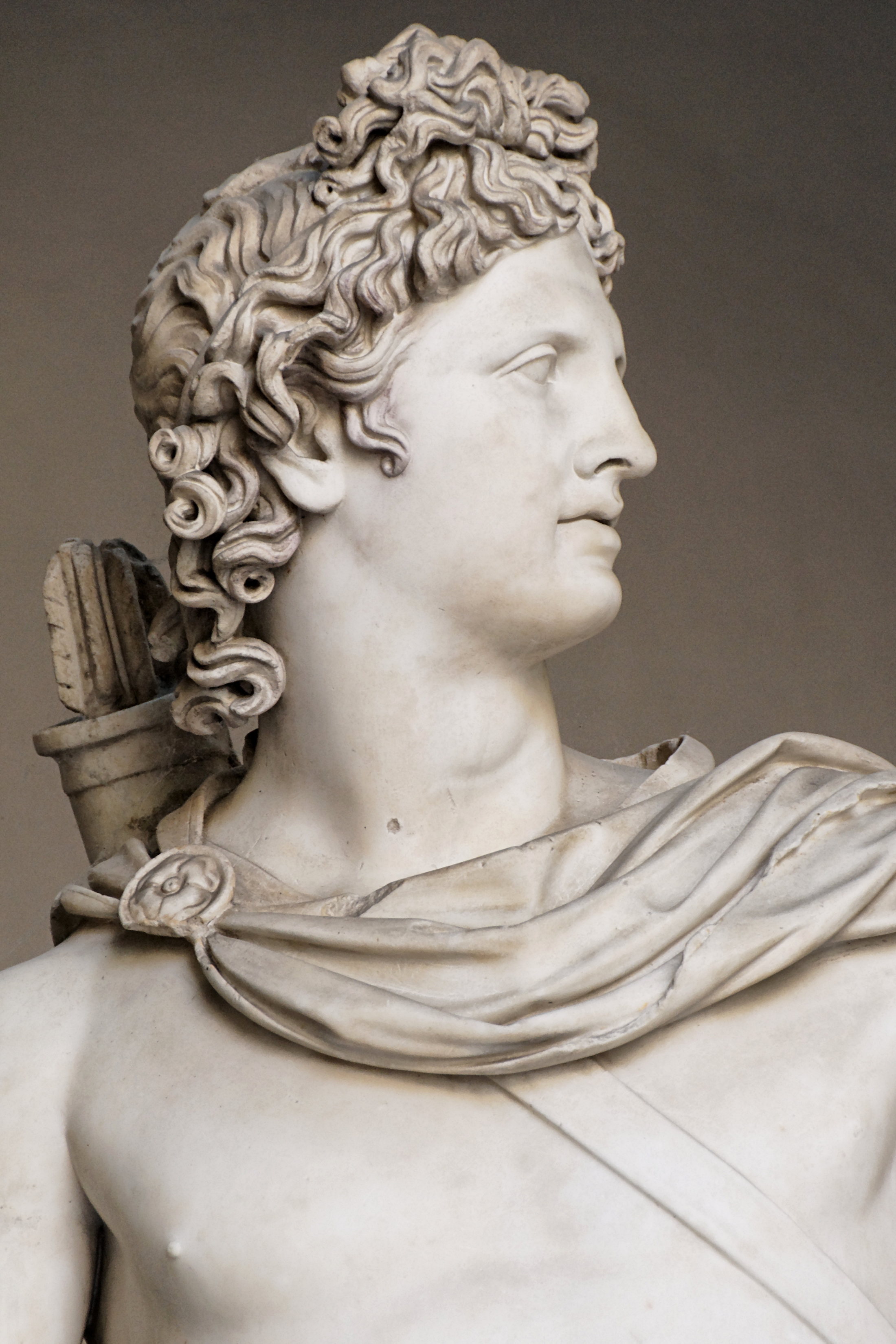
Teshub is depicted holding a triple thunderbolt and a weapon, usually an axe (often double-headed) or mace. The sacred bull common throughout Anatolia was his signature animal, represented by his horned crown or by his steeds Seri and Hurri, who drew his chariot or carried him on their backs.

According to Hittite myths, one of Teshub’s greatest acts was the slaying of the dragon Illuyanka. Myths also exist of his conflict with the sea creature (possibly a snake or serpent) Hedammu.

In the Hurrian schema, Teshub was paired with Hebat the mother goddess; in the Hittite, with the sun goddess Arinniti of Arinna – a cultus of great antiquity which has similarities with the venerated bulls and mothers at Çatalhöyük in the Neolithic era. His son was called Sarruma, the mountain god. The Phrygian goddess Cybele would then be the counterpart of the Hurrian goddess Hebat.

Hebat, Hepa; his wife, the mother goddess, regarded as the Sun goddess among the Hittites. Drawn from the Sumerian goddess Kubau, known as Hawwah, also known as Eve amongst the Aramaeans and some others.

Teshub’s brothers are Tigris (personification of the river), Ullikummi (stone giant), a giant stone monster, son of Kumarbi and the sea god’s daughter [Ullikummi's older brother, Hedammu, is a sea monster and appropriately the son of the sea god's daughter, Sertapsuruhi; Ullikummi himself is Kumarbi's son by a female cliff], and Tashmishu.

In Hittite and Hurrian mythology, Aranzah (or Aranzahas in the Hittite nominative form) is the Hurrian name of the Tigris River, which was divinized. He was the son of Kumarbi and the brother of Teshub and Tašmišu, one of the three gods spat out of Kumarbi’s mouth onto Mount Kanzuras. Later he colluded with Anu and the Teshub to destroy Kumarbi (The Kumarbi Cycle).

Ishkur in Sumerian, Adad in Akkadian, Amurru in Amoritic and Hadad in Aramaic

Kummanni, also known as Kumme, was still considered a holy city in Assyrian times, both in Assyria and in Urartu. Adad-nirari II, generally considered to be the first King of Assyria in the Neo-Assyrian period, after re-conquering the city, made sacrifices to “Adad of Kumme.”

Adad-nirari II is generally considered to be the first King of Assyria in the Neo-Assyrian period. He firmly subjugated the areas previously under only nominal Assyrian vassalage, conquering and deporting troublesome Aramean, Neo-Hittite and Hurrian populations in the north to far-off places.

Adad-nirari II then twice attacked and defeated Shamash-mudammiq of Babylonia, annexing a large area of land north of the Diyala River and the towns of Hīt and Zanqu in mid Mesopotamia. He made further gains over Babylonia under Nabu-shuma-ukin I later in his reign. He also campaigned to the west, subjugating the Aramean cities of Kadmuh and Nisibin. Along with vast amounts of treasure collected, he also secured the Kabur river region.

Ishkur in Sumerian, Adad in Akkadian, Amurru in Amoritic and Hadad in Aramaic are the names of the storm-god in the Babylonian-Assyrian pantheon. All three are usually written by the logogram dIM. The Akkadian god Adad is cognate in name and functions with northwest Semitic god Hadad.

In Akkadian, Adad is also known as Ramman (“Thunderer”) cognate with Aramaic Rimmon which was a byname of the Aramaic Hadad. Ramman was formerly incorrectly taken by many scholars to be an independent Babylonian god later identified with the Amorite god Hadad.

Amurru and Martu are names given in Akkadian and Sumerian texts to the god of the Amorite/Amurru people, often forming part of personal names. He is sometimes called Ilu Amurru (MAR.TU).

Amurru/Martu was probably a western Semitic god originally. He is sometimes described as a ‘shepherd’ or as a storm god, and as a son of the sky-god Anu. He was the patron god of the Mesopotamian city of Ninab, whose exact location is unknown.

Amurru also has storm-god features. Like Adad, Amurru bears the epithet ramān ‘thunderer’, and he is even called bāriqu ‘hurler of the thunderbolt’ and Adad ša a-bu-be ‘Adad of the deluge’. Yet his iconography is distinct from that of Adad, and he sometimes appears alongside Adad with a baton of power or throwstick, while Adad bears a conventional thunderbolt.

Amurru’s wife is sometimes the goddess Ašratum (see Asherah) who in northwest Semitic tradition and Hittite tradition appears as wife of the god Ēl which suggests that Amurru may indeed have been a variation of that god. If Amurru was identical with Ēl, it would explain why so few Amorite names are compounded with the name Amurru, but so many are compounded with Il; that is, with Ēl.

The Baal Cycle is a Ugaritic cycle of stories about the Canaanite god Baal, also known as Hadad the god of rain, storm and fertility. They are written in Ugaritic, a language written in a cuneiform alphabet, on a series of clay tablets found in the 1920s in the Tell of Ugarit (modern Ras Shamra), situated on the Mediterranean coast of northern Syria, a few kilometers north of the modern city of Latakia, far ahead of the now known coast.

The Sumerian Ishkur appears in the list of gods found at Fara but was of far less importance than the Akkadian Adad later became, probably partly because storms and rain are scarce in southern Babylonia and agriculture there depends on irrigation instead. Also, the gods Enlil and Ninurta also had storm god features which decreased Ishkur’s distinctiveness. He sometimes appears as the assistant or companion of one or the other of the two.

When Enki distributed the destinies, he made Ishkur inspector of the cosmos. In one litany Ishkur is proclaimed again and again as “great radiant bull, your name is heaven” and also called son of An, lord of Karkara; twin-brother of Enki, lord of abundance, lord who rides the storm, lion of heaven.

In other texts Adad/Ishkur is sometimes son of the moon god Nanna/Sin by Ningal and brother of Utu/Shamash and Inana/Ishtar. He is also occasionally son of Enlil. Adad/Ishkur’s special animal is the bull. He is naturally identified with the Anatolian storm-god Teshub.

Adad/Ishkur’s consort (both in early Sumerian and later Assyrian texts) was Shala, a goddess of grain, who is also sometimes associated with the god Dagan. She was also called Gubarra in the earliest texts. The fire god Gibil (named Gerra in Akkadian) is sometimes the son of Ishkur and Shala.

The lamassu

A lamassu is a protective deity, often depicted with a bull or lion’s body, eagle’s wings, and human’s head. In some writings, it is portrayed to represent a female deity. A less frequently used name is shedu which refers to the male counterpart of a lamassu.

The lamassu is a celestial being from Mesopotamian mythology. Human above the waist and a bull below the waist, it also has the horns and the ears of a bull. It appears frequently in Mesopotamian art, sometimes with wings. The lamassu and shedu were household protective spirits of the common Babylonian people, becoming associated later as royal protectors, were placed as sentinels at the entrances.[citation needed] The Akkadians associated the god Papsukkal with lamassu and the god Išum with shedu.

To protect houses, the lamassu were engraved in clay tablets, which were then buried under the door’s threshold. They were often placed as a pair at the entrance of palaces. At the entrance of cities, they were sculpted in colossal size, and placed as a pair, one at each side of the door of the city, that generally had doors in the surrounding wall, each one looking towards one of the cardinal points.

Adana

Adana’s name has had many different versions over the centuries: Adanos, Ta Adana, Uru Adaniya, Erdene, Edene, Ezene, Batana, Atana, Azana, Addane. The city Adana in southern Turkey is situated on the Seyhan River, 30 kilometres (19 miles) inland from the Mediterranean Sea, in south-central Anatolia. It is the administrative seat of the Adana Province and has a population of 1.6 million, making it the most populated city of the region. It is a major agricultural and commercial center.

Adana-Mersin metropolitan area, with a population of over 3 million, stretches over 70 kilometres (43 miles) from east to west and 25 kilometres (16 miles) from north to south; encompassing the cities of Mersin, Tarsus and Adana.

Adana Province is a province of Turkey located in south-central Anatolia. With a population of 2,085,225, it is the fifth most populous province in Turkey. The administrative seat of the province is the city of Adana, home to 78% of the residents of the province.

Adana is located in the heart of Çukurova, historically known as Cilicia, at the northeastern edge of the Mediterranean, where it serves as the gateway to the Çukurova plain, which has historically been known in the West as the Cilicia plain. This large stretch of flat, fertile land covers a geographical, economical and cultural region that includes the provinces of Mersin, Adana, Osmaniye, and Hatay southeast of the Taurus Mountains. Home to approximately six million people, the region is mostly a large stretch of flat, fertile land regarded as one of the most agriculturally productive areas of the world.

From Adana, crossing the Çukurova westwards, the road from Tarsus enters the foothills of the Taurus Mountains. The temperature decreases with every foot of ascent, as the road reaches an altitude of nearly 4,000 feet (1,200 m). It goes through the famous Cilician Gates, the rocky pass through which armies have coursed since the dawn of history, and continues to the Anatolian plain.

This region lies to the north-east of Cyprus, on the southern Anatolian coast where it meets Syria, stretching from its eastern plains (Celicia Pedias, or ‘flat’) to the rugged western section (Celicia Trachea, or ‘rugged’), formed by spurs of the Taurus mountains.

The history of the Tepebağ tumulus in the middle of Adana dates to the Neolithic Period, 6000 B.C., and the time of the first human settlements. It is considered to be the oldest city of the Çukurova region. A place called Adana is mentioned by name in a Sumerian epic, the Epic of Gilgamesh, but the geography of this work is too imprecise to identify its location.

Although it had been inhabited since the eighth millennium BC, it first emerged into history during the Hittite period where it formed part of Kizzuwatna, which according to the Hittite inscription of Kava, found in Hattusa (Boğazkale), was the first kingdom that ruled the ancient city of Adaniya, under the protection of the Hittites by 1335 BC.

At that time, the name of the city was Uru Adaniyya, and the inhabitants were called Danuna, and was one of the groups constituting the Sea Peoples, who were of Indo-European origin.

Beginning with the collapse of the Hittite Empire, c. 1191-1189 BC, invasions from the west caused a number of small kingdoms to take control of the plain, as follows: Quwê Assyrians, 9th century BC; Persians, 6th century BC; Alexander the Great in 333 BC; Seleucids; the pirates of Cilicia; Roman statesman Pompey the Great; and the Armenian Kingdom of Cilicia (Cilician Kingdom).

Khilakku (Cilicia) was a Luwian-speaking neo-Hittite state which emerged in former south-western Kizzuwatna in the mid-ninth century BC. It occupied a pocket of territory on the fertile coastal plains of Çukurova, ancient Cilicia, which was sandwiched between Tabal to the north and the kingdom of Que to the east. Its earlier Anatolian name of Khilikku came to be known as Cilicia by later Greeks and Romans.

In the 5th century BC Cilicia is invaded and annexed by Babylonian king Nergalsharusur, although some sources state that Appuashu resists him. The Persians take control of Cilicia. Although Appuashu probably resists again, this time he is unsuccessful and probably becomes a vassal for a decade or so. The region eventually forms part of the wide swathe of lands under the control of the Armenians and later the Lesser Armenians.

The history of Adana is intrinsically linked to the history of Tarsus, a historic city in south-central Turkey, 20 km inland from the Mediterranean Sea. They often seem to be the same city, moving as the neighbouring Seyhan River changed its position. Their respective names also changed over the course of the centuries. Adana was of relatively minor importance during the Roman’s influential period, while nearby Tarsus was the metropolis of the area.

Tarsus was located at the crossing of several important trade routes, linking Anatolia to Syria and beyond. Because the ruins are covered by the modern city, archaeology has barely touched the ancient city.

The ancient name is Tarsos, derived from “Tarsa”, the original name of the city in the Hittite language, which was possibly derived from a pagan god, Tarku, as Hittites were the first settlers. Excavation of the mound of Gözlükule, a tumulus within the borders of Tarsus city, Mersin Province, reveals that the prehistorical development of Tarsus reaches back to the Neolithic Period and continues unbroken through Chalcolithic and Early Bronze Ages.

With a history going back over 6,000 years, Tarsus has long been an important stop for traders, a focal point of many civilisations including the Roman Empire, when Tarsus was capital of the province of Cilicia, the scene of the first meeting between Mark Antony and Cleopatra, where Paul the Apostle was born.

Located on the mouth of the Berdan River (Cydnus of the antiquity), which empties into the Mediterranean Sea, Tarsus is a junction point of land and sea routes connecting the Cilician plain (today called Çukurova), central Anatolia and the Mediterranean sea. The climate is typical of the Mediterranean region, summers very very hot, winters chilly and damp.

Initially settled in the Neolithic Period, Gözlükule became an important settlement and a port during the 2nd millennium BC. It was located at the intersection of the main road systems, one following the Mediterranean sea side, the other following valleys through Toros Mountains to Anatolian plateau (so called Cicilian Gates). Eventually the city of Tarsus was established just north of Gözlükule. But Gözlükule was still active as the port of Cilicia. In 41 BC Cleopatra VII and Mark Antony entered Tarsus using the port of Gözlükule.

During the era of Pompey, the city was used as a prison for the pirates of Cilicia. For several centuries thereafter, it was a waystation on a Roman military road leading to the East. After the permanent split of the Roman Empire in 395 AD, the area became a part of the Byzantine Empire, and was probably developed during the time of Julian the Apostate.

With the construction of large bridges, roads, government buildings, irrigation and plantation, Adana and Cilicia became the most developed and important trade centers of the region. Ayas (today Yumurtalık), and Kozan (formerly Sis) were the other major urban and administrative centers in the area, especially during the period of the Cilicians.

Tarsus has a long history of commerce and is still a commercial centre today, trading in the produce of the fertile Çukurova plain; also Tarsus is a thriving industrial centre of refining and processing that produces some for export. Industries include agricultural machinery, spare parts, textiles, fruit-processing, brick building and ceramics.

Agriculture is an important source of income, half of the land area in the district is farmland (1,050 km²) and most of the remainder is forest and orchard. The farmland is mostly well-irrigated, fertilised and managed with the latest equipment.

Cilicia

The Cilician Gates or Gülek Pass is a pass through the Taurus Mountains connecting the low plains of Cilicia to the Anatolian Plateau, by way of the narrow gorge of the Gökoluk River. Its highest elevation is about 1000m.

The Cilician Gates have been a major commercial and military artery for millennia. In the early 20th century, a narrow-gauge railway was built through them, and today, the Tarsus-Ankara Highway (E90, O-21) passes through them.

The southern end of the Cilician gates is about 44 km north of Tarsus and the northern end leads to Cappadocia. This coast has been inhabited since the 9th millennium BC.

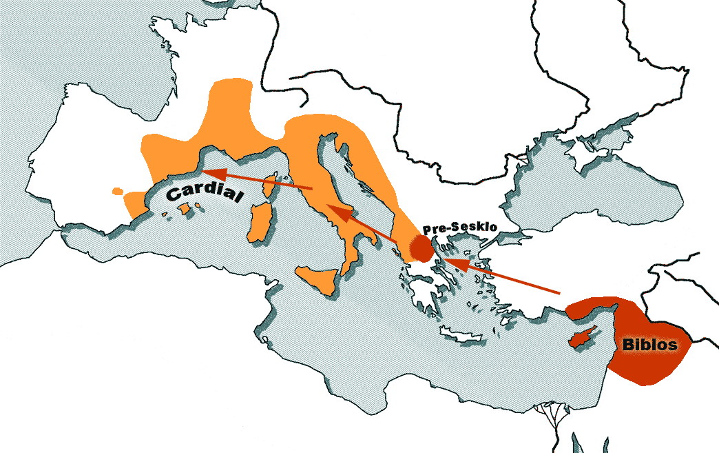
Cilicia was settled from the Neolithic period onwards. Dating of the ancient settlements of the region from Neolithic to Bronze Age is as follows: Aceramic/Neolithic: 8th and 7th millennia BC; Early Chalcolithic: 5800 BC; Middle Chalcolithic (correlated with Halaf and Ubaid developments in the east): c. 5400-4500 BC; Late Chalcolithic: 4500- c. 3400 BC; and Early Bronze Age IA: 3400-3000 BC; EBA IB: 3000-2700 BC; EBA II: 2700-2400 BC; EBA III A-B: 2400-2000 BC.

In antiquity, Cilicia was the south coastal region of Asia Minor, south of the central Anatolian plateau. It existed as a political entity from Hittite times into the Byzantine Empire. Cilicia extends inland from the southeastern coast of modern Turkey, due north and northeast of the island of Cyprus.

Cilicia extended along the Mediterranean coast east from Pamphylia, to the Amanus Mountains, which separated it from Syria. North and east of Cilicia lie the rugged Taurus Mountains that separate it from the high central plateau of Anatolia, which are pierced by a narrow gorge, called in Antiquity the Cilician Gates.

Ancient Cilicia was naturally divided into Cilicia Trachaea and Cilicia Pedias divided by the Lamas Su. Salamis, the city on the east coast of Cyprus, was included in its administrative jurisdiction.

The Greeks invented for Cilicia an eponymous Hellene founder in the purely mythic King Cilix, but the historic founder of the dynasty that ruled Cilicia Pedias was Mopsus, identifiable in Phoenician sources as Mpš, the founder of Mopsuestia who gave his name to an oracle nearby. Homer mentions the people of Mopsus, identified as Cilices, as from the Troad in the northernwesternmost part of the peninsula.

The kings of Adana are traced from the “house of Mopsos,” given in hieroglyphic Luwian as Moxos and in Phoenician as Mopsos, in the form mps. They were called the Dananiyim. The area also reports a Mopsukrene (Mopsus’ fountain in Greek) and a Mopsuhestia (Mopsus’ hearth in Greek), also in Cilicia.

Mopsus or Mopsos was the name of two famous seers in Greek mythology. A historical or legendary Mopsos or Mukšuš may have been the founder of a house in power at widespread sites in the coastal plains of Pamphylia and Cilicia (today’s Turkey) during the early Iron Age.

Mopsus, a celebrated seer and diviner, was the son of Manto, daughter of the mythic seer Tiresias, and of Rhacius of Caria or of Apollo himself, the oracular god. Greeks of the Classical age accepted Mopsus as a historical figure, though the anecdotes concerning him bridge legend and myth.

Cilicia Trachea (“rugged Cilicia”; the Assyrian Khilakku or Khilikku, also sometimes transcribed as Hilakku or Hilikku, classical “Cilicia”) is a rugged mountain district formed by the spurs of Taurus, which often terminate in rocky headlands with small sheltered harbors, a feature which, in classical times, made the coast a string of havens for pirates, but which in the Middle Ages led to its occupation by Genoese and Venetian traders.

The district is watered by the Calycadnus and was covered in ancient times by forests that supplied timber to Phoenicia and Egypt. Cilicia lacked large cities.

Cilicia Pedias (“flat Cilicia”— Greek: Κιλικία Πεδιάς; Assyrian Kue), to the east, included the rugged spurs of Taurus and a large coastal plain, with rich loamy soil, known to the Greeks such as Xenophon, who passed through with his 10,000 Greek mercenaries, for its abundance (euthemia), filled with sesame and millet and olives and pasturage for the horses imported by Solomon. Many of its high places were fortified.

The plain is watered by the three great rivers, the Cydnus (Tarsus Çay), the Sarus (Seyhan) and the Pyramus (Ceyhan), each of which brings down much silt from the deforested interior and which fed extensive wetlands. The Sarus now enters the sea almost due south of Tarsus, but there are clear indications that at one period it joined the Pyramus, and that the united rivers ran to the sea west of Kara-tash. Through the rich plain of Issus ran the great highway that linked east and west, on which stood the cities of Tarsus (Tarsa) on the Cydnus, Adana (Adanija) on the Sarus, and Mopsuestia (Missis) on the Pyramus.

The area had been known as Kizzuwatna in the earlier Hittite era (2nd millennium BC). The region was divided into two parts, Uru Adaniya (flat Cilicia), a well-watered plain, and “rough” Cilicia (Tarza), in the mountainous west.

The Cilicians appear as Khilikku in Assyrian inscriptions, and in the early part of the first millennium BC were one of the four chief powers of western Asia. Homer mentions the plain as the “Aleian plain” in which Bellerophon wandered, but he transferred the Cilicians far to the west and north and made them allies of Troy. The Cilician cities unknown to Homer already bore their pre-Greek names: Tarzu (Tarsus), Ingira (Anchiale), Danuna-Adana, which retains its ancient name, Pahri (perhaps modern Misis), Kundu (Kyinda, then Anazarbus) and Karatepe.

There exists evidence that circa 1650 BC both Hittite kings Hattusili I and Mursili I enjoyed freedom of movement along the Pyramus River (now the Ceyhan River in southern Turkey), proving they exerted strong control over Cilicia in their battles with Syria.

After the death of Murshili around 1595 BC, Hurrians wrested control from the Hitties, and Cilicia was free for two centuries. The first king of free Cilicia, Isputahsu, son of Pariyawatri, was recorded as a “great king” in both cuneiform and Hittite hieroglyphs. Another record of Hittite origins, a treaty between Ishputahshu and Telepinu, king of the Hittites, is recorded in both Hittite and Akkadian.

In the next century, Cilician king Pilliya finalized treaties with both King Zidanta II of the Hittites and Idrimi of Alalakh, in which Idrimi mentions that he had assaulted several military targets throughout Eastern Cilicia.

Niqmepa, who succeeded Idrimi as king of Alalakh, went so far as to ask for help from a Hurrian rival, Shaushtatar of Mitanni, to try and reduce Cilicia’s power in the region. It was soon apparent, however, that increased Hittite power would soon prove Niqmepa’s efforts to be futile, as the city of Kizzuwatna soon fell to the Hittites, threatening all of Cilicia. King Sunassura II was forced soon after to accept vassalization under the Hittites, and became the last king of ancient Cilicia.

In the 13th century BC, a major population shift occurred as the Sea Peoples, named by Egyptians as part Philistine, Sicilian, Tyrrhenian, Etruscan and Sardinian, overran Cilicia. The Hurrians that resided there deserted the area and moved northeast towards the Taurus, where they settled in the area of Cappadocia.

In the 8th century BC, the region was unified under the rule of the dynasty of Mukšuš, whom the Greeks rendered Mopsos and credited as the founder of Mopsuestia, though the capital was Adana. Its multicultural character is reflected in the bilingual inscriptions of the 9th and 8th centuries, written both in Indo-European hieroglyphic Luwian and West Semitic Phoenician.

In the 9th century BC the Assyrians began to conquer the region, and it became part of the Assyrian Empire until the late 7th century BC.

Under the Persian empire Cilicia was apparently governed by tributary native kings, who bore a Hellenized name or title of “Syennesis”; but it was officially included in the fourth satrapy by Darius. Xenophon found a queen in power, and no opposition was offered to the march of Cyrus the Younger.

The great highway from the west existed before Cyrus conquered Cilicia. On its long rough descent from the Anatolian plateau to Tarsus, it ran through the narrow pass between walls of rock called the Cilician Gates. After crossing the low hills east of the Pyramus it passed through a masonry (Cilician) gate, Demir Kapu, and entered the plain of Issus.

From that plain one road ran southward through another masonry (Syrian) gate to Alexandretta, and thence crossed Mt. Amanus by the Syrian Gate, Beilan Pass, eventually to Antioch and Syria; and another ran northwards through a masonry (Armenian) gate, south of Toprak Kale, and crossed Mt. Amanus by the Armenian Gate, Baghche Pass, to northern Syria and the Euphrates.

By the last pass, which was apparently unknown to Alexander, Darius crossed the mountains prior to the battle of Issus. Both passes are short and easy, and connect Cilicia Pedias geographically and politically with Syria rather than with Asia Minor.

Yamuktepe

Excavations by John Garstang of the hill of Yumuktepe (modern Mersin), which guards the Adana side of the gateway, have revealed 23 levels of occupation, the earliest dating from ca. 6300 BC. In the layer which corresponds to roughly 4500 BC, one of the oldest fortified settlements in human history exists, but the site appears to have been abandoned between 350 BC and 300 BC.

In his book named Prehistoric Mersin Garstang lists the tools unearthed in the excavations. The earliest tools are made of either stone or ceramic. Both agriculture and animal husbandry (sheep, cattle goats and porke) were among the economic activities in Yumuktepe.

According to Isabella Caneva, during chalcolithic age an early copper blast furnace was in use in Yumuktepe. Probably Yumuktepe was a coastal settlement. But because of the alluvion carried by the nearby river Müftü, now the mound is 2.5 kilometres (1.6 mi) north of the Mediterranean shore.

During historical era, Yumuktepe was a part of Kizuwatna a vassal kingdom of Hittite Empire. In a document of 1440 BC, the city of Pitura had been mentioned. Pitura might be the ancient name of the settlement. It seems, like most Hittite lands, sea people from Europe plundered Yumuktepe in 13th century BC. A second blow was from Assyrian Empire from Upper Mesopotamia.

In subsequent centuries, the city became a part of many states and civilizations including the Hittites, Assyrians, Persians, Greeks, Seleucids and Lagids. During the Ancient Greek period, the city bore the name Zephyrion and was mentioned by numerous ancient authors.

Apart from its natural harbor and strategic position along the trade routes of southern Anatolia, the city profited from trade in molybdenum (white lead) from the neighbouring mines of Coreyra. Ancient sources attributed the best molybdenum to the city, which also minted its own coins.

The area later became a part of the Roman province of Cilicia, which had its capital at Tarsus, while nearby Mersin was the major port. The city, whose name was Latinized to Zephyrium, was renamed as Hadrianopolis in honor of the Roman emperor Hadrian. During early Byzantine Empire, the nearby settlement of Soli (10 kilometres (6.2 mi) at the west) flourished and Yumuk was abandoned.

The ancient pathway was a track for mule caravans, not wheeled vehicles. In ancient history the Hittites, Greeks, Alexander the Great, the Romans, Mongols, and the Crusaders have all traveled this route during their campaigns. The Bible testifies that Saint Paul of Tarsus and Silas went this way as they went through Syria and Cilicia. The Book of Galatians speaks of the cities of Derbe, Lystra, and Iconium – cities visited by Paul on his first journey (Acts 14; Gal. 1:2), with the purpose of strengthening their churches, at the beginning of the second preaching journey (Acts 15:40-41).

The distance from the Anatolian plateau to the Cilician plain is about 110 kilometres (68 mi). In ancient times this was a journey of nearly five days. Saint Paul spoke, according to the Bible, about being in “dangers from rivers” and “dangers from robbers” (2 Cor. 11:26). This may explain why at 4.500 BCE, at the South Eastern end of the Cilician Gates was one of the world’s first existing fortresses (later Mersin). The Army of the Ten Thousand, Alexander the Great before the Battle of Issus, Paul of Tarsus on his way to the Galatians, and part of the army of the First Crusade all passed through the Cilician Gates, the site of the medieval fortress of Baberon (or Barbaron), then a stronghold of the medieval Armenian Principality of Cilicia.

When German engineers were working on the railroad link between Haydarpaşa Terminal in Istanbul, at the shore of the Sea of Marmara and Baghdad, they were unable to follow the steep-pitched, narrow, and tightly winding ancient track through the pass. The series of viaducts and tunnels they built are among the marvels of railroad engineering. The route was opened in 1918; the narrow-gauge working line moved Ottoman troops and war material to the Mesopotamian front in the closing months of World War I.

The Denyen

According to numerous sources, the name Adana is derived from the Hittite Adaniya of Kizzuwatna. According to the Hittite inscription of Kava, found in Hattusa (Boğazkale), a people called the Denyen or Danuna settle in Adana and are identified as inhabitants of the city Adana. The kingdom of Kizzuwatna was the first kingdom that ruled Adana, under the protection of the Hittites by 1335 BC. At that time, the name of the city was Uru Adaniyya, and the inhabitants were called Danuna.

They be could one of the groups constituting the Sea Peoples, known as the Denyen, who were of Indo-European origin. Other groups of Denyen are also believed to settle in Cyprus. After the collapse of the Mycenean civilization (1200 BC) some refugeees from the Aegean area went to the coast of Cilicia. The inhabitants Dananayim or Danuna are identified as one group of the sea-peoples who attacked Egypt on 1191 BC during the reign of Ramesses III.

Others assert that it is related to the legendary character Danaus, or to the Danaoi, a mythological Greek tribe who came from Egypt and established themselves in the Greek city Argos. The earlier Egyptian texts for a country Danaya are inscriptions from Thutmosis II (1437 BC) and Amenophis III (1390-1352 BC). It is also possible that the name is connected with the PIE da-nu (river) Da-na-vo (people living by the river), Scythian nomad people, water demons in Rigveda (Danavas).

In the Iliad of Homer, the city is called Adana. In Hellenistic times, it was known as Antiochia in Cilicia or Antiochia ad Sarum; “Antiochia on the Sarus”). The editors of The Helsinki Atlas tentatively identify Adana as Quwê (as contained in cuneiform tablets), the Neo-Assyrian capital of Quwê province. The name also appears as Coa, and may be the place referred to in the Bible, where King Solomon obtained horses. (I Kings 10:28; II Chron. 1:16). The Armenian name of the city is Atana or Adana.

According to an ancient Greco-Roman legend, the name has its origins in Adanus and Sarus, the two sons of Uranus, who came to a place near the Seyhan (Sarus) River, where they built Adana. An older legend relates the city’s name to Adad (also known as Tesup or Ishkur), the Thunder God in the Akkadian, Sumerian, Babylonian, Assyrian and Hittite mythologies, who was believed to live in the nearby forest, and whose name was given to the region.

The Hittites’ names and writings have been found in the area, evidencing this possibility. The theory goes that since the Thunder God brought so much rain and this rain in turn brought such great abundance in this particular region, this god was loved and respected by its inhabitants and, in his honor, the region was called the “Uru Adaniyya”; in other words “the Region of Ada”.

Quwê – also spelled Que, Kue, Qeve, Coa, Kuê and Keveh – was a “Neo-Hittite” Assyrian vassal state or province at various times from the 9th century BCE to shortly after the death of Ashurbanipal around 627 BCE in the lowlands of eastern Cilicia, and the name of its capital city, tentatively identified with Adana, in modern Turkey. According to many translations of the Bible, it was the place from which King Solomon obtained horses. (I Kings 10: 28, 29; II Chron. 1:16).

The Denyen

The Denyen have been identified with the people of Adana, in Cilicia who existed in late Hittite Empire times. They are also believed to have settled in Cyprus. A Hittite report speaks of a Muksus, who also appears in an eighth-century bilingual inscription from Karatepe in Cilicia.

They were raiders associated with the Eastern Mediterranean Dark Ages who attacked Egypt in 1207 BC in alliance with the Libyans and other Sea Peoples, as well as during the reign of Rameses III. The 20th Egyptian Dynasty allowed them to settle in Canaan, which was largely controlled by the Sea Peoples into the 11th century BC. Mercenaries from the Peleset manned the Egyptian garrison at Beth-shan, and the Denyen shared the same fashion as them which some archeology suggests signifies a shared cemetery there.

These areas also show evidence of close ties with the Aegean as a result of the Late Helladic IIIC 1b pottery found in these areas. Some scholars argue for a connection with the Greek Danaoi – alternate names for the Achaeans familiar from Homer. Greek myth refers to Danaos who with his daughters came from Egypt and settled in Argos. Through Danaë’s son, Perseus, the Danaans are said to have built Mycenae.

Dan

There are suggestions that the Denyen joined with Hebrews to form one of the original 12 tribes of Israel. The most famous Danite was Samson, whom some suggest is derived from Denyen tribal legends.

Modern artists use the “scales of justice” to represent the Tribe of Dan due to Genesis 49:16 referencing Dan judging his people. However, more traditional artists use a snake to represent Dan, based on Genesis 49:17.

A minority view first suggested by Yigael Yadin attempted to connect the Denyen with the Tribe of Dan “Judge”, also sometimes spelled as “Dann”, described as remaining on their ships in the early Song of Deborah, contrary to the mainstream view of Israelite history.

It was speculated that the Denyen had been taken to Egypt, and subsequently settled between the Caphtorite Philistines and the Tjekker, along the Mediterranean coast with the Tribe of Dan subsequently deriving from them.

They were excluded from the list of sealed tribes in the Book of Revelation for pagan practices, but they were given a northern portion of land in future Israel according to the Book of Ezekiel.

According to the Torah, the tribe consisted of descendants of Dan, a son of Jacob and Bilhah, Rachel’s maidservant (Genesis 30:4). In the biblical account, Dan is one of the two children of Bilhah, the handmaid of Jacob’s wife Rachel, the other child of Bilhah being Naphtali. Scholars see this as indicating that the authors saw Dan and Naphtali as being not of entirely Israelite origin (being descendants of handmaids rather than of full wives).

Some have noted that the territory of the handmaid tribes happens to be the territory closest to the north and eastern borders of Canaan, thus exposing them to Assyria and Aram. However, other tribes born to wives, including the firstborn Reuben, were also included on the eastern outskirts, and immediately adjacent to Israel’s more traditional enemies at the time of their entry to Canaan, the Moabites and Ammonites (wars with Aram and Assyria did not begin until over 500 years after the entry to Canaan- I Kings 11:25, II Kings 15:19).

The tribe was the last to receive its territorial inheritance. According to the biblical narrative, the tribe had originally tried to settle in the central coastal area of Canaan, but due to enmity with the Philistines who had already settled there, were only able to camp in the hill country overlooking the Sorek Valley, the camp location becoming known as Mahaneh Dan (“Camps of Dan”). (Joshua 19)

The region they were trying to settle included the area as far north as Joppa, and extending south into the Shephelah in the area of Timnah; as a result, the modern state of Israel refers to the region as Gush Dan (the Dan area). However, as a consequence of the pressure from the Philistines, the tribe abandoned hopes of settling near the central coast, instead migrating to the north of the country, and after conquering Laish, refounded it as their capital (renaming it Dan). (Judges 18)

According to the Hebrew Bible, following the completion of the conquest of Canaan by the Israelite tribes after about 1200 BCE, Joshua allocated the land among the twelve tribes. Dan was allocated the most northerly region, to the north of the Galilee, and west of the Jordan, stretching north as far as Laish, Dan’s main city (which became known as Dan). (Joshua 19:40-48)

In the Biblical census of the Book of Numbers, the tribe of Dan is portrayed as the second largest Israelite tribe (after Judah). Some textual scholars regard the census as being from the Priestly Source, dating it to around the 7th century BC, and more likely to reflect the biases of its authors, though this still implies that Dan was one of the largest tribes at a point fresh to the memories of the 7th century BC.

In the Blessing of Moses, which some textual scholars regard as dating from only slightly earlier than the deuteronomist, Dan is seemingly prophesied to leap from Bashan; scholars are uncertain why this should be since the tribe are not recorded as having ever been resident in the Bashan plain, which lies to the east of the Jordan.

From after the conquest of the land by Joshua until the formation of the first Kingdom of Israel in c. 1050 BC, the Tribe of Dan was a part of a loose confederation of Israelite tribes. No central government existed, and in times of crisis the people were led by ad hoc leaders known as Judges.

With the growth of the threat from Philistine incursions, the Israelite tribes decided to form a strong centralised monarchy to meet the challenge, and the Tribe of Dan joined the new kingdom with Saul as the first king.

After the death of Saul, all the tribes other than Judah remained loyal to the House of Saul, but after the death of Ish-bosheth, Saul’s son and successor to the throne of Israel, the Tribe of Dan joined the other northern Israelite tribes in making David, who was then the king of Judah, king of a re-united Kingdom of Israel. However, on the accession of Rehoboam, David’s grandson, in c. 930 BC the northern tribes split from the House of David to reform a Kingdom of Israel as the Northern Kingdom.

As part of the Kingdom of Israel, the territory of Dan was conquered by the Assyrians, and exiled; the manner of their exile led to their further history being lost.

Ethiopian Jews, also known as Beta Israel, claim descent from the Tribe of Dan, whose members migrated south along with members of the Tribes of Gad, Asher, and Naphtali, into the Kingdom of Kush, now Ethiopia and Sudan, during the destruction of the First Temple. This position is supported by former Sephardic Chief Rabbi Ovadia Yosef. They are said to have fought with the natives. Religious writers have tried to attach the serpent voodoo God Danbhala to this group, as the practice they suggest was a heterodox form of Ethiopian Judaism.

According to the Book of Revelation (7:4-8), the tribe of Dan is the only original tribe of Israel which is not included in the list of tribes which are sealed. No mention is made of why they are excluded. It has been suggested that this could be because of their pagan practices. This made Hippolytus of Rome and a few Millennialists propose that the Antichrist will come from the tribe of Dan.

Samson

Samson (meaning “man of the sun”) or Sampson, is one of the last of the Judges of the ancient Israelites mentioned in the Hebrew Bible (Book of Judges chapters 13 to 16).

According to the biblical account, Samson was given supernatural strength by God in order to combat his enemies and perform heroic feats such as killing a lion, slaying an entire army with only the jawbone of an ass, and destroying a pagan temple. Samson had two vulnerabilities, however: his attraction to untrustworthy women and his hair, without which he was powerless. These vulnerabilities ultimately proved fatal for him.

Samson is believed by Jews and Christians to have been buried in Tel Tzora in Israel overlooking the Sorek valley. There reside two large gravestones of Samson and his father Manoah. Nearby stands Manoah’s altar (Judges 13:19–24). It is located between the cities of Zorah and Eshtaol.

Samson’s activity takes place during a time when God was punishing the Israelites, by giving them “into the hand of the Philistines”. The Angel of the Lord appears to Manoah, an Israelite from the tribe of Dan, in the city of Zorah, and to his wife, who had been unable to conceive. The Angel of the Lord proclaims that the couple will soon have a son who will begin to deliver the Israelites from the Philistines.

The wife believed the Angel of the Lord, but her husband wasn’t present, at first, and wanted the heavenly messenger to return, asking that he himself could also receive instruction about the child who was going to be born.

Requirements were set up by the Angel of the Lord that Manoah’s wife (as well as the child) were to abstain from all alcoholic beverages, and her promised child was not to shave or cut his hair. He was to be a “Nazirite” from birth. In ancient Israel, those wanting to be especially dedicated to God for a while could take a nazarite vow, which included things like the aforementioned as well as other stipulations.

After the Angel of the Lord returned, Manoah soon prepared a sacrifice, but the Angel of the Lord would only allow it to be for God, touching his staff to it, miraculously engulfing it in flames. The Angel of the Lord then ascended up into the sky in the fire revealing that it had been God in angelic form, as the Angel of the Lord and “an” angel are two different things.

This was such dramatic evidence as to the nature of the Messenger, that Manoah feared for his life, as it has been said that no-one can live after seeing God; however, his wife soon convinced him that if God planned to slay them, he would never have revealed such things to them to begin with. In due time the son, Samson, is born; he is reared according to these provisions.

Academics have interpreted Samson as a demi-god (such as Hercules or Enkidu) enfolded into Jewish religious lore, or as an archetypical folklore hero, among others. These views sometimes interpreted him as a solar deity, popularized by “solar hero” theorists and Biblical scholars alike. The name Delilah may also involve a wordplay with the Hebrew word for night, ‘layla’, which “consumes” the day.

Samson bears many similar traits to the Greek Herakles (and the Roman Hercules adaptation), inspired himself partially from the mesopotamian Enkidu tale: Herakles and Samson both battled a Lion bare handed (Lion of Nemea feat), Herakles and Samson both had a favorite primitive blunt weapon (a club for the first, an ass’s jaw for the latter), they were both betrayed by a woman which led them to their ultimate fate (Herakles by Dejanira, while Samson by Delilah). Both heroes, champion of their respective people, die by their own hand: Herakles ends his life on a pyre while Samson makes the Philistine temple collapse upon himself and his enemies.

Danaus

In Greek mythology Danaus, or Danaos, was the twin brother of Aegyptus and son of Achiroe and Belus, a mythical king of Egypt. The myth of Danaus is a foundation legend (or re-foundation legend) of Argos, one of the foremost Mycenaean cities of the Peloponnesus. In Homer’s Iliad, “Danaans” (“tribe of Danaë”) and “Argives” commonly designate the Greek forces opposed to the Trojans.

Danaus had fifty daughters, the Danaides, twelve of whom were born to Polyxo and the rest to Pieria and other women, and his twin brother, Aegyptus, had fifty sons. Aegyptus commanded that his sons marry the Danaides. Danaus elected to flee instead, and to that purpose, he built a ship, the first ship that ever was.

In Greek mythology, the Daughters of Danaus, also Danaids, Danaides or Danaïdes, were the fifty daughters of Danaus. They were to marry the fifty sons of Danaus’s twin brother Aegyptus, a mythical king of Egypt. In the most common version of the myth, all but one of them killed their husbands on their wedding night, and are condemned to spend eternity carrying water in a sieve or perforated device. In the classical tradition, they come to represent the futility of a repetitive task that can never be completed (see also Sisyphus).

Tell Dan

Dan, is a city mentioned in the Bible, described as the northernmost city of the Kingdom of Israel, belonging to the Tribe of Dan. The city is identified with the tel known as Tel Dan (“Mound of Dan”), or Tel el-Qadi (“Mound of the Judge”, literal translation of the Hebrew name Tel Dan, “Dan” meaning “judge”, or “one who judges”) in Israel.

Dan is situated in Israel, in the area known as the Galilee Panhandle. To the west is the southern part of Mount Lebanon; to the east and north are the Hermon mountains. Melting snow from the Hermon mountains provides the majority of the water of the Jordan River, and passes through Dan, making the immediate area highly fertile. The lush vegetation that results makes the area around Dan seem somewhat out of place in the otherwise arid region around it.

According to the archaeological excavations at the site, the town was originally occupied in the late Neolithic era (c 4500 BCE), although at some time in the fourth millennium BC it was abandoned, for almost 1,000 years.

Dan was first identified by Edward Robinson in 1838, and has been securely identified with the archaeological site of Tel Dan, which the Book of Judges (Judges 18:27-29) states was known as Laish prior to its conquest by the Tribe of Dan, whereas in Joshua 19:47 it is called Leshem.

According to the Book of Judges, prior to the Tribe of Dan occupying the land, the town was known as Laish, and allied with the Sidonians; This might indicate they were Phoenicians (Sidonians were Phoenicians from the city of Sidon), who may or may not have been Canaanite.

Sidon has been inhabited since very early in prehistory. The archaeological site of Sidon II shows a lithic assemblage dating to the Acheulean, whilst finds at Sidon III include a Heavy Neolithic assemblage suggested to date just prior to the invention of pottery. It was one of the most important Phoenician cities, and may have been the oldest. From here, and other ports, a great Mediterranean commercial empire was founded.

Homer praised the skill of its craftsmen in producing glass, purple dyes, and its women’s skill at the art of embroidery. It was also from here that a colonizing party went to found the city of Tyre. Tyre also grew into a great city, and in subsequent years there was competition between the two, each claiming to be the metropolis (‘Mother City’) of Phoenicia.

Glass manufacturing, Sidon’s most important enterprise in the Phoenician era, was conducted on a vast scale, and the production of purple dye was almost as important. The small shell of the Murex trunculus was broken in order to extract the pigment that was so rare it became the mark of royalty.

The alliance had little practical benefit due to the remoteness of the town from Sidon, and the intervening Lebanon mountains. The town was also isolated from the Assyrians and Aram by the Hermon mountains; the Septuagint mentions that the town was unable to have an alliance with the Aramaeans. The masoretic text does not mention the Aramaeans, but instead states that the town had no relationship with any man – textual scholars believe that this is a typographic error, with adham (man) being a mistake for aram.

According to Judges concerning Micah’s Idol, the Tribe of Dan did not at that point have any territory to their name (Judges 18:1), and so, after scouting out the land, eventually decided to attack Laish, as the land around it was fertile, and the town was demilitarised.

Most Biblical scholars now believe that the Tribe of Dan originated as one of the Sea Peoples, hence remaining on their ships in the early Song of Deborah, and not having Israelite land to their name, though conservative scholars argue that the Tribe of Dan migrated because they were forced out of their original lands by the Philistines.

The Bible describes the Tribe of Dan brutally defeating the people of Laish and burning the town to the ground, and then building their own town in the same spot. The narrative states that Laish subsequently became known as Dan, after the name of the tribe, and that it housed a sanctuary filled with idols, which remained in use until the time of captivity of the land and the time that the house of God ceased to be in Shiloh.

Scholars think that the former refers to the Assyrian conquest of the Kingdom of Israel by Tiglath-pileser III in 733/732 BCE, and that the latter refers to the time of Hezekiah’s religious reform; an alternative possibility, however, supported by a minority of scholars, is that time of captivity of the land is a typographic error and should read time of captivity of the ark, referring to the battle of Eben-Ezer, and the Philistine capture of the Ark, and that the ceasing of the house of God being in Shiloh refers to this also.

According to 2 Kings 10:29 and 2 Chronicles 13:8, Jeroboam erected two golden calves as gods in Bethel and Dan. Textual scholars believe that this is where the Elohist story of Aaron’s Golden Calf actually originates, due to opposition in some sections of Israelite society (including the Elohist themselves) to the seeming idol-worship of Jeroboam.

However, Biblical scholars believe that Jeroboam was actually trying to outdo the sanctuary at Jerusalem (Solomon’s Temple), by creating a seat for God that spanned the whole kingdom of Israel, rather than just the small space above the Ark of the Covenant in Jerusalem; the seat for God in the Jerusalem sanctuary was represented by a cherubim on either side, while scholars believe that Jeroboam was using the calves to represent the sides of his seat for God – implying his whole kingdom was equal in holiness to the Ark.

Within the remains of the city wall, close to the entrance of the outer gate, parts of the Tel Dan Stele were found. The basalt stone bears an Aramaic inscription referring to one of the kings of Damascus; the excavators of the site believe that the king it refers to is Hazael (c 840 BCE), though a minority argue that it instead refers to Ben-Hadad (c 802 BCE).

A small part of the inscription remains, with text containing the letters, which some archaeologists agree refers to House of David (Beth David in Hebrew. In the line directly above, the text reads ‘MLK YSR’L', i.e. “King of Israel”. Hebrew script from the era is vowel-less), which would make the inscription the first time that the name David has been found at an archaeological site dating before 500 BCE.

Dan suffered in the era of expansion by the Aramaeans, due to being the closest city to them in the kingdom of Israel. The several incursions indicated by the Book of Kings suggest that Dan changed hands at least four times between the Kingdom of Israel and Aramaeans, around the time that Israel was ruled by Ahab and the Aramaeans by Ben Hadad I, and their successors. Around this time, the Tel Dan stele was created by the Aramaeans, during one of the periods of their control of Dan. When the Assyrian empire expanded to the south, the kingdom of Israel initially became a vassal state, but after rebelling, the Assyrians invaded, the town fell to Tiglath-pileser III in 733/732 BCE.

In 1992, in order to tidy up the site for presentation to visitors, a heap of debris was removed which dated from the time of the Assyrian destruction of the city by Tiglath-pileser III in 733/2 BCE. A hitherto unknown earlier gateway to the city was uncovered. The entrance complex led to a courtyard paved with stone with a low stone platform. In the 9th century BCE, the podium was enlarged, and major fortifications were built, a city wall with buttresses and a complex gate. The podium was enlarged further in the 8th century BCE by Jeroboam II, then destroyed by Tiglath-pileser III.


Filed under: Uncategorized

Ugaritic Baal and Anat Cycle

Arima, Couch of Typhoeus

$
0
0

Arima, couch of Typhoeus, the most deadly monster of Greek mythology, as Homer expresses it, is a hard-to-place site in Greek mythology, said to be where Zeus defeated Typhon and where Echidna dwells. Hylea is pointed to be where was the Echidna’s cave between people Arimi or Harimi, the Greeks on the Euxine believed that this was somewhere in Scythia.

The last son of Gaia, fathered by Tartarus, Typhoeus was known as the “Father of All Monsters”; his wife Echidna (“she viper”), who was half woman half snake, was likewise known as the “Mother of All Monsters” because most of the monsters in Greek myth were mothered by her.

Hesiod’s Theogony described her as: [...] the goddess fierce Echidna who is half a nymph with glancing eyes and fair cheeks, and half again a huge snake, great and awful, with speckled skin, eating raw flesh beneath the secret parts of the holy earth. And there she has a cave deep down under a hollow rock far from the deathless gods and mortal men. There, then, did the gods appoint her a glorious house to dwell in: and she keeps guard in Arima beneath the earth, grim Echidna, a nymph who dies not nor grows old all her days.

According to Apollodorus, Echidna was the daughter of Tartarus and Gaia, while according to Hesiod, either Ceto and Phorcys or Chrysaor and the naiad Callirhoe were her parents.

Another account says her parents were Peiras and Styx (according to Pausanias, who did not know who Peiras was aside from her father). Echidna was a drakaina, with the face and torso of a beautiful woman (depicted as winged in archaic vase-paintings) and the body of a serpent, sometimes having two serpent’s tails.

She is also sometimes described, as Karl Kerenyi noted, in archaic vase-painting, with a pair of echidnas performing sacred rites in a vineyard, while on the opposite side of the vessel, goats were attacking the vines: thus chthonic Echidnae are presented as protectors of the vineyard.

The site of her cave Homer calls “Arima, couch of Typhoeus”. When she and her mate attacked the Olympians, Zeus beat them back and punished Typhon by sealing him under Mount Etna. However, Zeus allowed Echidna and her children to live as a challenge to future heroes.

Although to Hesiod, she was an immortal and ageless nymph, according to Apollodorus, Echidna used to “carry off passers-by”, until she was finally killed where she slept by Argus Panoptes, the hundred-eyed giant.

Echidna is also sometimes identified as the mother by Heracles, a divine hero in Greek mythology, the son of Zeus and Alcmene, foster son of Amphitryon and great-grandson (and half-brother) of Perseus, of Scythes, along with his brothers Agathyrsus and Gelonus, (or Geloni), also known as Helonians (or Heloni).

While Scythes is an eponymous king of the Scythians, Iranic equestrian tribes who were mentioned as inhabiting large areas in the central Eurasian steppes starting with the 7th century BC up until the 4th century AD, Agathyrsus is an eponymous king of the Agathyrsi, a people of Scythian, or mixed Dacian-Scythian origin, who in the time of Herodotus occupied the plain of the Maris (Mures), in the mountainous part of ancient Dacia now known as Transylvania, Romania.

Herodotus states that the Geloni, which are mentioned as a nation in northwestern Scythia, were originally Hellenes who settled among the Scythian tribe Budini, who according to some researchers were a Finnic tribe ruled by the Scythians, and that they are bilingual in Greek and the Scythian language.

Their capital was called Gelonos or Helonos, originally a Greek market town. In his account of Scythia, Herodotus writes that the Gelonii were formerly Greeks, having settled away from the coastal emporia among the Budini, where they “use a tongue partly Scythian and partly Greek”:

“The Budini for their part, being a large and numerous nation, is all mightily blue-eyed and ruddy. And a city among them has been built, a wooden city, and the name of the city is Gelonus. Of its wall then in size each side is of thirty stades and high and all wooden. And their homes are wooden and their shrines. For indeed there is in the very place Greek gods’ shrines adorned in the Greek way with statues, altars and wooden shrines and for triennial Dionysus festivals in honour of Dionysus…

Above the Sauromatae (Sarmatians), possessing the second region, dwell the Budini, whose territory is thickly wooded with trees of every kind. The Budini are a large and powerful nation: they have all deep blue eyes, and bright red hair.

The Budini, however, do not speak the same language as the Geloni, nor is their mode of life the same. They are the aboriginal people of the country, and are nomads; unlike any of the neighbouring races, they eat lice.

Their country is thickly planted with trees of all manner of kinds. In the very woodiest part is a broad deep lake, surrounded by marshy ground with reeds growing on it. Here otters are caught, and beavers, with another sort of animal which has a square face.

With the skins of this last the natives border their capotes: and they also get from them a remedy, which is of virtue in diseases of the womb… Beyond the Budini, as one goes northward, first there is a desert, seven days’ journey across…

The fortified settlement of Gelonus was reached by the Persian army of Darius in his assault on Scythia during the 5th century BC, and burned to the ground, the Budini having abandoned it in their flight before the Persian advance.

The Scythians sent a message to Darius: “We are free as wind and what you can catch in our land is only the wind”. By employing a scorched earth strategy, they avoided battles, leaving “earth without grass” by burning the steppe in front of the advancing Persians (Herodotus). The Persian army returned without a single battle or any significant success.

Recent digs in Bilsk, Ukraine have uncovered a vast city identified by the Kharkov archaeologist Boris Shramko as the Scythian capital Gelonus.

The name according to Herodotus, who took his mythology from “the Greeks who dwell about the Pontos”, derives from their eponymous mythical founder, Gelonus brother of Scythes, sons of Heracles, an expression of observed cultural links in genealogical terms. Herodotus also mentions that the Greeks apply the ethnonym both to the actual Gelonians of Greek origin and by extension to the Budinoi.

At the end of the fourth century AD, Claudian in his Against Rufinus (book 1) polemically portrays the tribes of Scythia as prototypical barbarians: There march against us a mixed horde of Sarmatians and Dacians, the Massagetes who cruelly wound their horses that they may drink their blood, the Alans who break the ice and drink the waters of Maeotis’ lake, and the Geloni who tattoo their limbs: these form Rufinus’ army.

Sidonius Apollinaris, the cultured Gallo-Roman poet of the sixth century, includes Geloni, “milkers of mares” (equimulgae) among tribal allies participating in the Battle of Chalons against Attila in 451 AD.

E.A. Thompson expresses his suspicions about some of these names: The Bastarnae, Bructeri, Geloni and Neuri had disappeared hundreds of years before the times of the Huns, while the Bellonoti had never existed at all: presumably the learned poet was thinking of the Balloniti, a people invented by Valerius Flaccus nearly four centuries earlier.

Later located eastward probably on the middle course of the Volga about Samara, the Budini are described as fair-eyed and red-haired, and lived by hunting in the dense forests.

The 1911 Britannica surmises that they were Fenno-Ugric, of the branch now represented by the Udmurts and Komis (this branch is now called “Permic”), forced northwards by later immigrants. In their country was a wooden city called Gelonos, inhabited with a “distinct race”, the Geloni, who according to Herodotus were Greeks that became assimilated to the Scythians.

Later writers add nothing to our knowledge of the Budini, and are more interested in the tarandus, an animal that dwelt in the woods of the Budini, possibly the reindeer (Aristotle ap. Aelian, Hist. Anim. xv. 33).

The Udmurts are a people who speak the Udmurt language of the Uralic family. Through history they have been known in Russian as Chud Otyatskaya, Otyaks, or Votyaks (most known name), and in Tatar as Ar.

The name Udmurt probably comes from *odo-mort ‘meadow people,’ where the first part represents the Permic root *od(o) ‘meadow, glade, turf, greenery’ (related to Finnish itää ‘to germinate, sprout’) and the second part (Udmurt murt ‘person’; cf. Komi mort, Mari mari) is an early borrowing from Indo-Iranian *mertā or *martiya ‘person, man’ (cf. Urdu/Persian mard). This is supported by a document dated Feb. 25, 1557, in which alongside the traditional Russian name otyaki the Udmurts are referred to as lugovye lyudi ‘meadow people’.

On the other hand, in the Russian tradition, the name ‘meadow people’ refers to the inhabitants of the left bank of river general. Recently, the most relevant is the version of V. V. Napolskikh and S. K. Belykh. They suppose that ethnonym was borrowed from the Iranian entirely: *anta-marta ‘resident of outskirts, border zone’ (cf. Antes) → Proto-Permic *odə-mort → Udmurt udmurt.

Most Udmurt people live in Udmurtia. Small groups live in the neighboring areas: Kirov Oblast and Perm Krai of Russia, Bashkortostan, Tatarstan, and Mari El.

Anthropologists relate Udmurts to the Urals branch of Europeans. Most of them are of the middle size, often have blue or gray eyes, high cheek-bones and wide face. The Udmurt people are not of an athletic build but they are very hardy and there have been claims that they are the “most red-headed” people in the world. Additionally, the ancient Budini tribe, which is speculated to be an ancestor of the modern Udmurts, were described by Herodotus as being predominantly red-headed.

Typhon was described in pseudo-Apollodorus, Bibliotheke, as the largest and most fearsome of all creatures. His human upper half reached as high as the stars, and his hands reached east and west. Instead of a human head, a hundred dragon heads erupted from his neck and shoulders (some, however, depict him as having a human head, with the dragon heads replacing the fingers on his hands).

His bottom half consisted of gigantic viper coils that could reach the top of his head when stretched out and constantly made a hissing noise. His whole body was covered in wings, and fire flashed from his eyes, striking fear even into the Olympians.

Typhon attempts to destroy Zeus at the will of Gaia, because Zeus had imprisoned the Titans. Typhon overcomes Zeus in their first battle, and tears out Zeus’ sinews. However, Hermes recovers the sinews and restores them to Zeus. Typhon is finally defeated by Zeus, who traps him underneath Mount Etna.

Typhon may be derived from the Greek (typhein), to smoke, hence it is considered to be a possible etymology for the word typhoon, supposedly borrowed by the Persians (as Tufân) and Arabs to describe the cyclonic storms of the Indian Ocean.

The Greeks also frequently represented him as a storm-demon, especially in the version where he stole Zeus’s thunderbolts and wrecked the earth with storms (cf. Hesiod, Theogony; Nonnus, Dionysiaca).

Typhon was known to be a large humanoid beast. Typhon was the last child of Gaia. After the defeat of his brothers, the Gigantes, Gaia urged him to avenge them, as well as his other brothers, the Titans.

In the alternative account of the origin of Typhon (Typhoeus), the Homeric Hymn to Apollo makes the monster Typhaon at Delphi a son of archaic Hera in her Minoan form, produced out of herself, like a monstrous version of Hephaestus or Mars, and whelped in a cave in Cilicia and confined there in the enigmatic Arima, or land of the Arimoi, en Arimois (Iliad, ii. 781–783).

It was in Cilicia that Zeus battled with the ancient monster and overcame him, in a more complicated story: It was not an easy battle, and Typhon temporarily overcame Zeus, cut the “sinews” from him and left him in the “leather sack”, the korukos that is the etymological origin of the korukion andron, the Korykian or Corycian Cave located on the slopes of Mount Parnassus, in Greece in which Zeus suffers temporary eclipse as if in the Land of the Dead.

The region of Cilicia in southeastern Anatolia had many opportunities for coastal Hellenes’ connection with the Hittites to the north. From its first reappearance, the Hittite myth of Illuyankas has been seen as a prototype of the battle of Zeus and Typhon.

Walter Burkert and Calvert Watkins each note the close agreements. Watkins’ How to Kill a Dragon: Aspects of Indo-European Poetics (Oxford University Press) 1995, reconstructs in disciplined detail the flexible Indo-European poetic formula that underlies myth, epic and magical charm texts of the lashing and binding of Typhon.

Since Herodotus, Typhon has been identified by some scholars with the Egyptian Set. In the Orphic tradition, Typhon leads the Titans when they attack and kill Dionysus, just as Set is responsible for the murder of Osiris. Furthermore, the slaying of Typhon by Zeus bears similarities to the killing of Vritra by Indra (a deity also associated with lightning and storms), and possibly the two stories are ultimately derived from a common Indo-European source.

Similarities can be found in the battle between Thor and Jormungand from Norse myths, as well as (perhaps) an incident in the Irish Metrical Dindsenchas in which the Dagda fights a giant octopus. Mythologist Joseph Campbell also makes parallels to the slaying of Leviathan by YHWH, about which YHWH boasts to Job.

Comparisons can also be drawn with the Mesopotamian monster Tiamat and its slaying by Babylonian chief god Marduk. The similarities between the Greek myth and its earlier Mesopotamian counterpart do not seem to be merely accidental. A number of west Semitic (Ras Shamra) and Hittite sources appear to corroborate the theory of a genetic relationship between the two myths.

In the Iliad, following the catalogue of ships, Homer returns to describing the tramp of the huge Achaean army; it is like the resounding earth beneath the “anger of Zeus who delights in thunder, whenever he lashes the ground around Typhoeus in Arima (en Arimois), where they say is Typhoeus’ bed”. “Even the ancients were uncertain,” Robin Lane Fox observes, in preface to offering an identification of “Arima”.

Some readers have assumed that an unattested people, the Arimoi, were intended. Homer’s interjection “they say” seems to place Arima at a certain remove from his experience and those of his hearers. “It is clear that ancient critics did not know which region this signified,” comments G.S. Kirk concerning this passage.

Hesiod remarks that “Arima” is where Echidna, the chthonic mate of Typhon, dwells, “there in earth’s secret places. For there she has her cave on the underside of a hollow rock, far from the immortal gods, and far from all mortals. There the gods ordained her a fabulous home to live in which she keeps underground among the Arimoi, grisly Ekhidna.”

A fragment from a lost poem of Pindar notes that in the “highly celebrated Corycian cave”, “once, among the Arimoi” Zeus had battered Thyphoeus, with “fifty” heads.

Strabo gives a brief list of the places where “Arima” had been sited by previous writers: Lydia, Syria, Cilicia, and even Sicily and the west.

Fox notes that in north Syria, where the early Greek trading post of Al Mina lay, the presence, from the ninth century onwards, the presence of “Aramaeans”, speaking and writing Aramaic. Even earlier, royal Assyrian texts of c. 1060 refers to a land A-ri-me, A-ri-mi or A-ra-me eastwards in Mesopotamia; its people recur in a text of Sargon c. 710 BCE A-ra-me.

The truth is more subtle than a simple identification with such a “distant hint”, as Fox demonstrates, linking myth, surviving inscriptions and other documentation to identify “Arima” with the territory surrounding the Corycian cave, an identification first made by Alexander’s historical advisor, Callisthenes: “the Arimoi are located by the Corycian cave near Calycadnus and the promontory of Sarpedon; the neighboring mountains are called ‘Arima’”.

Fox confirms Callisthenes with an inscription in the temple built at the cave’s entrance that records a visitor’s propitiation of Pan and Hermes, at this “broad recess in the earth at Arima”; Hermes and goat-Pan (Aigipan) rescued Zeus, deprived of his “sinews” from his first defeat at the hands of Typhon.

Fox notes that “in inscriptions found at the nearby settlement of Corycos, Zeus is specifically entitled the ‘Zeus of Victory,’ referring to his victory, therefore, in the war with Typhon”; he also notes in passing the earlier Hittite place name Erimma in Cilicia.

Corycus was an ancient city in Cilicia Trachaea, Anatolia, located at the mouth of the river called Şeytan deresi; the site is now occupied by the town of Kızkalesi (formerly Ghorgos), Mersin Province, Turkey.

In the Corycian Cave (now Cennet ve Cehennem), 20 stadia inland, says Strabo, the best crocus (saffron) grows. He describes this cave as a great hollow, of a circular form, surrounded by a margin of rock, on all sides of a considerable height; on descending into this cavity, the ground is found to be uneven and generally rocky, and it is filled with shrubs, both evergreen and cultivated; in some parts the saffron is cultivated: there is also a cave here which contains a large source, which pours forth a river of pure, pellucid water, but it immediately sinks into the earth, and flowing underground enters the sea: they call it the Bitter Water.

Pomponius Mela (i.13) has a long description of the same place apparently from the same authority that Strabo followed, but more embellished. This place is probably on the top of the mountain above Corycus.

This place is famed in Greek mythology. It is the Cilician cave of Pindar (Pythian Ode i. 31), and of Aeschylus (Prom. Vinct. 350), and as Arima, couch of Typhoeus, it is the lair of Zeus’ fiercest opponent, the giant Typhon or Typhoeus.

Cennet and Cehennem (English: heaven and hell) are the names of two big sinkholes on the Taurus Mountains, in Mersin Province, Turkey. They are situated next to each other in the rural area of Silifke district which in turn is a part of Mersin Province.

Top opening of Cennet is 250 x 110 m2 ( 820 x 360 ft2 ) and its average dept is 70 metres (230 ft). It is possible to reach the bottom of Cennet by a primitive staircase composed of 300 steps. At the bottom towards south, there is a smaller and 150 steps deeper cave. In this cave are the ruins of a monastery built in the 5th century by a certain Paulus and dedicated to Virgin Mary. In this monastery one can hear the sound of a small underground stream from the monastery to the gulf of Narlıkuyu.

Cehennem is a deeper sinkhole with a depth of 128 metres (420 ft). But its top opening is smaller with dimensions 70 x 50 m2 ( 210 x 150 ft2 ) . More over, the upper edge of the opening is concave. So, it is impossible to reach the bottom of Cehennem.

In antiquity this coast was part of Cilicia, named for a Phoenician or Assyrian prince that had settled here. Trade from Syria and Mesopotamia over the mountains to central Anatolia passed through here, through the Cilician Gates. The geographer Strabo, described the region as being divided into “Rugged Cilicia” and “Flat Cilicia”. The capital of both sections of Cilicia was Tarsus and Mersin was its seaport.

The Cilician Gates or Gülek Pass is a pass through the Taurus Mountains connecting the low plains of Cilicia to the Anatolian Plateau, by way of the narrow gorge of the Gökoluk River. Its highest elevation is about 1000m.

The Cilician Gates have been a major commercial and military artery for millennia. In the early 20th century, a narrow-gauge railway was built through them, and today, the Tarsus-Ankara Highway (E90, O-21) passes through them.

The southern end of the Cilician gates is about 44 km north of Tarsus and the northern end leads to Cappadocia.

Yumuktepe (modern Mersin), which guards the Adana side of the gateway, with 23 layers of occupation, is at 4,500 BCE, one of the oldest fortified settlements in the world. The ancient pathway was a track for mule caravans, not wheeled vehicles. In ancient history the Hittites, Greeks, Alexander the Great, the Romans, Mongols, and the Crusaders have all traveled this route during their campaigns. The Bible testifies that Saint Paul of Tarsus and Silas went this way as they went through Syria and Cilicia. The Book of Galatians speaks of the cities of Derbe, Lystra, and Iconium – cities visited by Paul on his first journey (Acts 14; Gal. 1:2), with the purpose of strengthening their churches, at the beginning of the second preaching journey (Acts 15:40-41).

The distance from the Anatolian plateau to the Cilician plain is about 110 kilometres (68 mi). In ancient times this was a journey of nearly five days. Saint Paul spoke, according to the Bible, about being in “dangers from rivers” and “dangers from robbers” (2 Cor. 11:26). This may explain why at 4.500 BCE, at the South Eastern end of the Cilician Gates was one of the world’s first existing fortresses (later Mersin). The Army of the Ten Thousand, Alexander the Great before the Battle of Issus, Paul of Tarsus on his way to the Galatians, and part of the army of the First Crusade all passed through the Cilician Gates, the site of the medieval fortress of Baberon (or Barbaron), then a stronghold of the medieval Armenian Principality of Cilicia.

When German engineers were working on the railroad link between Haydarpaşa Terminal in Istanbul, at the shore of the Sea of Marmara and Baghdad, they were unable to follow the steep-pitched, narrow, and tightly winding ancient track through the pass. The series of viaducts and tunnels they built are among the marvels of railroad engineering. The route was opened in 1918; the narrow-gauge working line moved Ottoman troops and war material to the Mesopotamian front in the closing months of World War I.


Filed under: Uncategorized

The Budini with their deep blue eyes and bright red hair

$
0
0

The Budini (Greek: Boudinoi) were an ancient people who lived in Scythia, in what is today Ukraine. In his account of Scythia (Inquiries book 4), Herodotus writes that the Geloni were formerly Greeks, having settled away from the coastal emporia among the Budini, where they “use a tongue partly Scythian and partly Greek”:

“The Budini for their part, being a large and numerous nation, is all mightily blue-eyed and ruddy. And a city among them has been built, a wooden city, and the name of the city is Gelonus.

Of its wall then in size each side is of thirty stades and high and all wooden. And their homes are wooden and their shrines. For indeed there is in the very place Greek gods’ shrines adorned in the Greek way with statues, altars and wooden shrines and for triennial Dionysus festivals in honour of Dionysus.”

“Above the Sauromatae (Sarmatians), possessing the second region, dwell the Budini, whose territory is thickly wooded with trees of every kind. The Budini are a large and powerful nation: they have all deep blue eyes, and bright red hair.

The Budini, however, do not speak the same language as the Geloni, nor is their mode of life the same. They are the aboriginal people of the country, and are nomads; unlike any of the neighbouring races, they eat lice.

Their country is thickly planted with trees of all manner of kinds. In the very woodiest part is a broad deep lake, surrounded by marshy ground with reeds growing on it. Here otters are caught, and beavers, with another sort of animal which has a square face.

With the skins of this last the natives border their capotes: and they also get from them a remedy, which is of virtue in diseases of the womb… Beyond the Budini, as one goes northward, first there is a desert, seven days’ journey across…”

The fortified settlement of Gelonus was reached by the Persian army of Darius in his assault on Scythia during the 5th century BC, already burned to the ground, the Budini having abandoned it before the Persian advance.

The Scythians sent a message to Darius: “We are free as wind and what you can catch in our land is only the wind”. By employing a scorched earth strategy, they avoided battles, leaving “earth without grass” by burning the steppe in front of the advancing Persians (Herodotus). The Persian army returned without a single battle or any significant success.

Later located eastward probably on the middle course of the Volga about Samara, the Budini are described as fair-eyed and red-haired, and lived by hunting in the dense forests. In their country was a wooden city called Gelonos, inhabited with a “distinct race”, the Geloni, who according to Herodotus were Greeks that became assimilated to the Scythians. Later writers add nothing to our knowledge of the Budini, and are more interested in the tarandus, an animal that dwelt in the woods of the Budini, possibly the reindeer (Aristotle ap. Aelian, Hist. Anim. xv. 33).

Red hair is the rarest natural hair color in humans. The non-tanning skin associated with red hair may have been advantageous in far-northern climates where sunlight is scarce. Studies by Bodmer and Cavalli-Sforza (1976) hypothesized that lighter skin pigmentation prevents rickets in colder climates by encouraging higher levels of Vitamin D production and also allows the individual to retain heat better than someone with darker skin.

In 2000, Harding et al. concluded that red hair was not the result of positive selection and instead proposed that it occurs because of a lack of negative selection. In Africa, for example, red hair is selected against because high levels of sun would be harmful to untanned skin. However, in Northern Europe this does not happen, so redheads come about through genetic drift.

According to some researchers, the Budinis were a Finnic tribe ruled by the Scythians. The 1911 Britannica surmises that they were Fenno-Ugric, of the branch now represented by the Udmurts and Komis (this branch is now called “Permic”), forced northwards by later immigrants. Edgar V. Saks identifies Budini as Votic people, a people of Votia in Ingria, the part of modern-day northwestern Russia that is roughly southwest of Saint Petersburg and east of the Estonian border-town of Narva.

Udmurts

The Udmurts are a people who speak the Udmurt language. Through history they have been known in Russian as Chud Otyatskaya, Otyaks, or Votyaks (most known name), and in Tatar as Ar. The Udmurt language belongs to the Uralic family.

The name Udmurt probably comes from *odo-mort ‘meadow people,’ where the first part represents the Permic root *od(o) ‘meadow, glade, turf, greenery’ (related to Finnish itää ‘to germinate, sprout’) and the second part (Udmurt murt ‘person’; cf. Komi mort, Mari mari) is an early borrowing from Indo-Iranian *mertā or *martiya ‘person, man’ (cf. Urdu/Persian mard). This is supported by a document dated Feb. 25, 1557, in which alongside the traditional Russian name otyaki the Udmurts are referred to as lugovye lyudi ‘meadow people’.

On the other hand, in the Russian tradition, the name ‘meadow people’ refers to the inhabitants of the left bank of river general. Recently, the most relevant is the version of V. V. Napolskikh and S. K. Belykh. They suppose that ethnonym was borrowed from the Iranian entirely: *anta-marta ‘resident of outskirts, border zone’ (cf. Antes) → Proto-Permic *odə-mort → Udmurt udmurt.

Anthropologists relate Udmurts to the Urals branch of Europeans. Most of them are of the middle size, often have blue or gray eyes, high cheek-bones and wide face. The Udmurt people are not of an athletic build but they are very hardy. and there have been claims that they are the “most red-headed” people in the world. Additionally, the ancient Budini tribe, which is speculated to be an ancestor of the modern Udmurts, were described by Herodotus as being predominantly red-headed.

Most Udmurt people live in Udmurtia. Small groups live in the neighboring areas: Kirov Oblast and Perm Krai of Russia, Bashkortostan, Tatarstan, and Mari El. The Udmurt population is shrinking; the Russian census reported 637,000 of them in 2002, compared to 746,562 in 1989.

Komi

Based on linguistic reconstruction, the prehistoric Permians are assumed to have split into two peoples during the first millennium BC: the Komis and the Udmurts. Around 500 AD, the Komis further divided into the Komi-Permyaks (who remained in the Kama River basin) and the Komi-Zyrians (who migrated north).

The name “Komi” may come from the Udmurt word “kam” (meaning “large river”, particularly the River Kama) or the Udmurt “kum” (meaning “kinfolk”). The scholar Paula Kokkonen favours the derivation “people of the Kama”. The name “Zyrian” is disputed, but may be from a personal name Zyran.

The Komi or Zyrian people is an ethnic group whose homeland is in the north-east of European Russia around the basins of the Vychegda, Pechora and Kama rivers. They mostly live in the Komi Republic, Perm Krai, Murmansk Oblast, Khanty–Mansi Autonomous Okrug, and Yamalo-Nenets Autonomous Okrug in the Russian Federation. They belong to the Permian branch of the Uralic peoples.

The Komis are divided into eight sub-groups. Their northernmost sub-group is also known as the Komi-Izhemtsy (from the name of the river Izhma) or Iz’vataz. This group numbers 15,607. This group is distinct for its more traditional, strongly subsistence based economy which includes reindeer husbandry. Komi-Permyaks (125,235 people) live in Perm Krai (Komi-Yazvas group) and Kirov Oblast (Upper-Kama Komi group) of Russia.

The Komi language belongs to the Permian branch of the Uralic family. There is limited mutual intelligibility with Udmurt. There are three main dialects: Pechora, Udor and Verkhne-Vyshegod. Until the 18th century, Komi was written in the Old Permic alphabet introduced by Saint Stephen of Perm in the 14th century. Cyrillic was used from the 19th century and briefly replaced by the Latin alphabet between 1929 and 1933. The Komi language is currently written in Cyrillic, adding two extra letters – Іі and Ӧӧ – to represent vowel sounds which do not exist in Russian. The first book to be printed in Komi (a vaccination manual) appeared in 1815.

From the 12th century the Russians began to expand into the Perm region and the Komis came into contact with Novgorod. Novgorodian traders travelled to the region in search of furs and animal hides.

The Novgorodians referred to the southern Komi region as “the Great Perm”. Komi dukes unified the Great Perm with its centre at the stronghold of Cherdyn. As the Middle Ages progressed, Novgorod gave way to Moscow as the leading Russian power in the region.

In 1365, Dmitry Donskoy, Prince of Moscow, gave Stephen of Perm the task of converting the region to Christianity. Stephen’s mission led to the creation of the eparchy of Perm in 1383 and, after his death, Stephen became the patron saint of the Komis. He also devised an alphabet for the Komi language.

Nevertheless, some Komis resisted Christianisation, notably the shaman Pama. The Duke of Perm only accepted baptism in 1470 (he was given the Christian name Mikhail), possibly in an attempt to stave off Russian military pressure in the region.

Mikhail’s conversion failed to stop an attack by Moscow which seized Cherdyn in 1472. Mikhail was allowed to keep his title of duke but was now a vassal of Moscow. The duchy only survived until 1505 when Mikhail’s son Matvei was replaced by a Russian governor and Komi independence came to an end.

In the 1500s many Russian migrants began to move into the region, beginning a long process of colonisation and attempts at assimilating the Komis. Syktyvkar was founded as the chief Russian city in the region in the 18th century. The Russian government established penal settlements in the north for criminals and political prisoners.

There were several Komi rebellions in protest against Russian rule and the influx of Slav settlers, especially after large numbers of freed serfs arrived in the region from the 1860s. A national movement to revive Komi culture also emerged.

Russian rule in the area collapsed after World War I and the revolutions of 1917. In the subsequent Russian Civil War, the Bolsheviks fought the Allies for control of the region. The Allied interventionist forces encouraged the Komis to set up their own independent state with the help of political prisoners freed from the local penal colonies.

After the Allies withdrew in 1919, the Bolsheviks took over. They promoted Komi culture but increased industrialisation damaged the Komis’ traditional way of life. Stalin’s purges of the 1930s devastated the Komi intelligentsia, who were accused of “bourgeois nationalism”.

The remote and inhospitable region was also regarded as an ideal location for the prison camps of the Gulag. The influx of political prisoners and the rapid industrialisation of the region as a result of World War II left the Komis a minority in their own lands.

Stalin carried out further purges of the Komi intellectual class in the 1940s and 1950s, and Komi language and culture was suppressed. Since the end of the Soviet Union in 1991, the Komis have reasserted their claims to a separate identity.

Most Komis belong to the Russian Orthodox Church, but their religion often contains traces of pre-Christian beliefs of the traditional mythology of the Komi people of northern Russia. A large number of Komis are Old Believers, which are Christians that separated after 1666 from the official Russian Orthodox Church as a protest against church reforms introduced by Patriarch Nikon between 1652 and 1666. Old Believers continue liturgical practices which the Russian Orthodox Church maintained before the implementation of these reforms.

Votes

Votes are the oldest known ethnic group in Ingria. They are probably descended from an Iron-age population of north-eastern Estonia and western Ingria. Some scientists claim they were a tribe of Estonians, who developed a separate identity during isolation from other Estonians. It is speculated the ancient Estonian county of Vaiga got its name from Votians. The Kylfings, a people active in Northern Europe during the Viking Age, may have also been Votes.

Earliest literary references of Votes by their traditional name are from middle-age Russian sources, where Votes are referred to as Voď. They were previously considered Chudes together with Estonians in Russian sources, and Lake Peipus near Votian homelands is called Chudsko ozero, meaning “Lake of Chudes” in Russian.

Veliky Novgorod (also Novgorod the Great), or just Novgorod, is one of the oldest cities of Russia, founded in the 9th or 10th century, and most important historic cities in Russia. It serves as the administrative center of Novgorod Oblast. It is situated on the M10 federal highway connecting Moscow and St. Petersburg. The city lies along the Volkhov River just downstream from its outflow from Lake Ilmen. UNESCO recognised Novgorod as a World Heritage Site in 1992.

The Sofia First Chronicle first mentions it in 859; the Novgorod First Chronicle mentions it first in the year 862, when it was allegedly already a major station on the trade route from the Baltics to Byzantium.

Archaeological excavations in the middle to late 20th century, however, have found cultural layers dating back only to the late 10th century, the time of the Christianization of Rus’ and a century after it was allegedly founded, suggesting that the chronicle entries mentioning Novgorod in the 850s or 860s are later interpolations.

In 1069 Votes were mentioned taking part in an attack on the Novgorod Republic by the Principality of Polotsk. Eventually Votes became part of the Novgorod Republic and in 1149 they were mentioned taking part in an attack by Novgorod against Jems who are speculated to be peoples of Tavastia. One of the administrative divisions of Novgorod, Voch’skaa, was named after Votes. After the collapse of Novgorod, the Grand Duchy of Moscow deported many Votes from their homelands and began more aggressive conversion of them.

Missionary efforts started in 1534, after Novgorod’s archbishop Macarius complained to Ivan IV that Votes were still practicing their pagan beliefs. Makarius was authorized to send monk Ilja to convert the Votes. Ilja destroyed many of the old holy shrines and worshiping places. Conversion was slow and the next archbishop Feodosii had to send priest Nikifor to continue Ilja’s work. Slowly Votes were converted and they became devoted Christians.

Sweden controlled Ingria in the 17th century, and attempts to convert local Orthodox believers to the Lutheran faith caused some of the Orthodox population to migrate elsewhere. At the same time many Finnish peoples immigrated to Ingria. Religion separated the Lutheran Finns and Orthodox Izhorians and Votes, so intermarriage was uncommon between these groups. Votes mainly married other Votes, or Izhorians and Russians. They were mostly trilingual in Votic, Izhoran and Russian.

Ingrian (also called Izhorian) is a nearly extinct Finnic language spoken by the (mainly Orthodox) Izhorians of Ingria. It has approximately 120  speakers left, most of whom are aging. It should not be confused with the Southeastern dialects of the Finnish language that became the majority language of Ingria in the 17th century with the influx of Lutheran Finnish immigrants (whose descendants, Ingrian Finns, are often referred to as Ingrians).

The immigration of Lutheran Finns was promoted by Swedish authorities (who gained the area from Russia in 1617), as the local population was (and remained) Orthodox.

In 1848, the number of Votes had been 5,148, (Ariste 1981: 78). but in the Russian census of 1926 there were only 705 left. From the early 20th century on, the Votic language no longer passed to following generations. Most Votes were evacuated to Finland along with Finnish Ingrians during World War II, but were returned to the Soviet Union later.

As a distinct people, Votes have become practically extinct after Stalinist dispersion to distant Soviet provinces as ‘punishment’ for alleged disloyalty and cowardice during World War II. Expelees allowed to return in 1956 found their old homes occupied by Russians.

In 1989, there were still 62 known Votes left, with the youngest born in 1930. There were 73 self-declared Votes in the 2002 Russian census. Of them 12 lived in St. Petersburg, 12 in Leningrad Oblast and 10 in Moscow. In 2008 Votes were added to the list of Indigenous peoples of Russia, granting them some support to preserving their culture.

There have been some conflicts with Votic villagers and foresters, and in 2001 the Votic museum was burned in the village of Lužitsõ. Another possible problem is a port which is being constructed to Ust-Luga. It is planned that some 35,000 people would move near historic Votic and Izhoran villages.

The Votes in Latvia were called krieviņi in Latvian. The word comes from krievs, which means “Russian”. Historical sources indicate the Teutonic Knights led by Vinke von Overberg captured many people in Ingermanland during their attack there in 1444–1447, and moved them to Bauska, where a workforce was needed to build a castle. It is estimated that some 3,000 people were transferred there. After the castle was built, the Votes did not go back, but were settled in the vicinity of Bauska and became farmers.

Gradually, they forgot their own language and customs and were assimilated by the neighboring Latvians. They are first mentioned in literature of 1636. The first “modern” scientist to study them was Finnish Anders Johan Sjögren, but the first person to connect them with Votes was Ferdinand Johan Wiedemann in 1872. Latvian poet Jānis Rainis had some Votic roots.

Most Votes were able to speak Izhorian and Russian as well as the Votic language. In fact, Izhorian was more common in every day use than Votic in some villages. Votic was commonly used with family members, while Russian and Izhorian were used with others. Russian was the only language used in Churches. Votes often referred to themselves as Izores, since this term was more commonly known among others. The term came in use when people wanted to make a difference between Lutheran and Orthodox Finnic populations in Ingria.

The Votic language is still spoken in three villages of historical Votia and by an unknown number of fluent Votic speakers in the countryside. The villages are Jõgõperä (Krakolye), Liivcülä (Peski), and Luuditsa (Luzhitsy).


Filed under: Uncategorized

The Waugh Family An historical and photographic perspective

$
0
0

The Waugh Family
An historical and photographic perspective

“Waugh was the name given to our people (the Britons) by the Anglo-Saxons”

The Waugh Family An historical and photographic perspective 

“Waugh was the name given to our people (the Britons) by the Anglo-Saxons”

Walhaz

*Walhaz (ᚹᚨᛚᚺᚨᛉ) is a reconstructed Proto-Germanic word, meaning “foreigner”, “stranger”, “Roman”, “Romance-speaker”, or “Celtic-speaker”. The term was used by the ancient Germanic peoples to describe inhabitants of the former Roman Empire, who were largely romanised and spoke Latin or Celtic languages.

The adjectival form is attested in Old Norse valskr, meaning “French”, Old High German walhisk, meaning “Romance”, Modern German welsch, used in Switzerland and South Tyrol for Romance-speakers, Dutch waals “Walloon”, Old English welisċ, wælisċ, wilisċ, meaning “Romano-British”, and Modern English Welsh.

The form of these words imply that they are descended from a Proto-Germanic form *walhiska-. It is attested in the Roman Iron Age Tjurkö Bracteate inscription as walhakurne “Roman/Gallic grain”, apparently a kenning for “gold” (referring to the “bracteate” itself).


Filed under: Uncategorized
Viewing all 1677 articles
Browse latest View live